I am a professional Urban Planner and Designer. I treat this as my thought laboratory exploring how bionomics relate to self-organizing, emergent urbanism.
As a professional urban designer and partner of the Planning and Design Firm Space Between Design Studio, I am a trained urbanist who specializes in creating walkable urban developments and analyzing existing places to find the barriers preventing livable, walkable urbanism. I can be reached at patrick [at] spacebtw.com
Blogging Towards a Brighter Planet
CarFreeInBigD Store
under construction
Tags
Showing posts with label Ameliorating Highways. Show all posts
Showing posts with label Ameliorating Highways. Show all posts
Councilperson Angela Hunt was interviewed by DMN transportation reporter Michael Lindenberger where she dropped this dime:
She was asked: If we don't expand highways, how are we going to reduce traffic in downtown?
"That to me is the most important question we can be asking ourselves," she said. "No one involved in transportation in a governmental sense, as far as I can tell, is asking the question or is interested in the answer to the question. But do we want to differentiate Dallas and help it grow into the future or not? We've expanded lots of lanes of road over past decade and yet our city did not grow in the last Census. I think that is significant. That is what we got for our highway money. We've allowed people to move further and further away.
And that is the real question. Why does every single person in transportation governance in DFW mistakenly think that they can build their way out of congestion through additional capacity? It's either incompetence or corruption of the highest order. Here is part of the reason, my piece on the four blind spots of transportation planning that inevitably leads them to supply-side solutions, as in additional supply, more roads, in the folly-fueled pursuit of free-flowing movement.
Know where I was most mobile in the last year? When I visited London and Barcelona. I could get anywhere and everywhere in those cities very cheaply and efficiently. Pedestrians and trains are always free-flowing, even when they're "congested." Because, like cholesterol, there is a good kind and a bad kind of "congestion." Pedestrian congestion nourishes real estate value and quality of place. It fosters authentic places by empowering the citizenry. It ensures long-term health, vitality, and resilience of a place long into an uncertain future of fluctuating gas prices and infrastructural upkeep. Ask Detroit how monotony of car-culture is working out.
While Lindenberger is right to pose the question, the answer really isn't that difficult. Building for regional transportation movement (to the point that it physically encumbers local movement and the value of proximity -- despite gas, operations, and maintenance costs to the private user that cripple the local economy) skews the real estate market towards car-based and regional development, ie sprawl. As cities are highly complex, adaptive systems, we have to understand that people (and in turn the real estate markets) adapt to changing transportation networks.
In other words, enough to build a modern streetcar line down Ross Avenue from West End to Lowest Greenville. The 20,000 new residents could walk, bike, and trolley to places of need. Because the value of proximity is restored. Or they could drive. The key factor is choice is restored and intelligence is built into the system via the users. They can choose the most appropriate and desirable form of transportation for their given needs for any given trip. Thus, less vehicle miles traveled and reduced demand. Meaning less cars on the street, less load on crippled, failing infrastructure, more free-flowing traffic (of all forms), and increased efficiency through propinquity.
The reason is that the highest and best use of land is for surface parking...or nothing at all. Vacant. The highways skew the housing and real estate market to favor shipping tax base outside of the city's boundaries while the city bears the infrastructural burden for a region of 6 million. Its rapid growth itself is indicative not of strength in the market, but fragility. It can go away just as fast.
If we're serious about revitalizing downtown, the answer isn't more highways. It's less. I was interviewed late last week by a writer in Baltimore covering the impending tearout of the JFX, I-83, which splits Baltimore in two, west and east, right down the middle. He was very interested in Fort Worth's relocation of I-30. I told him the effect of doing so was negligible and likely would remain so.
Sure, it enlarged downtown some, but it does little to change the movement patterns and demand levels built into the real estate market via transportation network. Capacity remained the same. The effort to move cars freely and easily is what makes it cheaper and easier to live outside the city (with your tax dollars) and commute into the city. It isn't a healthy interdependent relationship cities have with their suburbs (say, like Valencia Sp has), but rather a dependent one of host organism and parasite, sapping the host of its life. Slowly. And surely.
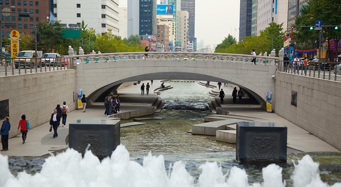
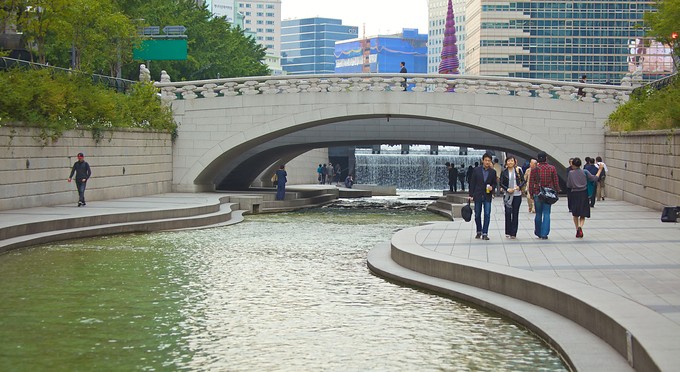
I was posting these nuggets to twitter, so I might as well bring them over here in full. Below is some data I've dug up on the Cheonggye Freeway in Seoul, SK that was removed and the buried stream was restored:
Removed 8.5 miles, which moved 1.5 million cars per day.
Cost: $33 million per mile to remove and restore stream.
Within ten years of the initial elevated highway construction, Seoul CBD lost 40,000 residents and 80,000 jobs.
Afterwards:
Housing value increased 30%
Number of vehicles in the area per day dropped 43%
Summer temperatures: 8 degrees cooler
Air quality: 21% less tiny particulate matter called PM10
NO2 dropped 20%
BETX pollutants dropped 25% overall and 65% in certain areas
125,000 visitors come to the park each weekend day. 53,000 during weekdays
113,000 new jobs have been created along the corridor
long term economic benefits estimated between $8.5 and 25 billion
I've been beating the drum lately on what exactly is the purpose of our road network? What is the purpose of our city? The city is a system with a purpose to serve human need and the movement infrastructure is a subsystem that must be subservient to the larger need. Instead, we build for "growth" rather than any real purpose, say, like say safety, security, and social/economic economic exchange.
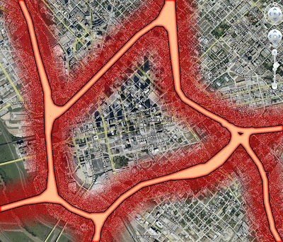
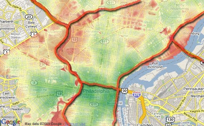
Let's unpack some of these with the help of a few graphics I've used in the past and one new one. First, we look at Philadelphia and a the correlation between crime and highway locations:
Red is higher crime areas per capita, green lower. Other than 676 the Vine Street Expressway, red areas line up with the freeways. Crime often occurs more often in the dark and is more comfortable occurring in places where people aren't, disconnected places. The Vine Street Expressway is sunken and the grid remains intact. Not ideal, but better than the alternative.
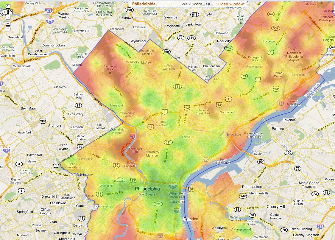
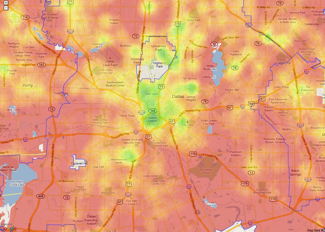
Now, we look at a comparison in walkscore heat maps of Philadelphia and Dallas:
Again, red bad green good, that is if you assume not having to own a car to participate in the local economy is a good thing. I obviously do. Why force people into upwards of 40% of their income dedicated to transportation? In these situations, attempting to make transit work is rather desperate and service is always less convenient than the car, since the entire city framework is built solely for car use.
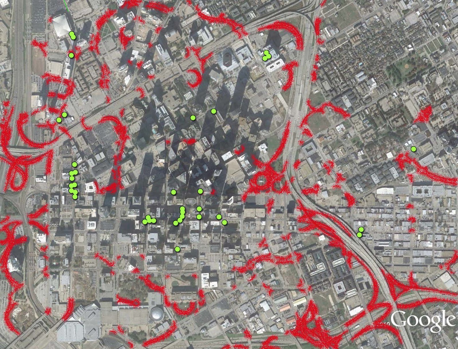
Next we have a look at downtown Dallas where I mapped outdoor cafe seating mashed up with what I deemed to be overly large radii, the curvature of roads and off-ramps meant for "efficiency" of car movement, ie not to stop or slow cars:
Rarely do cafe seats occur within proximity of high speed traffic, it is simply uncomfortable and undesirable to do so. Of this map, it should be noted that many of these aren't doing so well and aren't often populated, with the exception of the most interconnected and slowest speed traffic areas of the Main Street core.
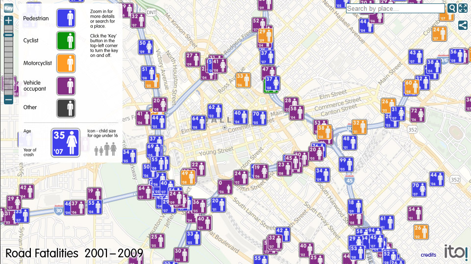
Next is safety. Here is a map cropped of the immediate downtown area showing where traffic fatalities have occurred between 2001-2009:
Blue is pedestrian, purple is vehicle occupant. As you see, the most align with the freeways. Isn't the first role of public governance to keep people safe? Or building roads they can't maintain?
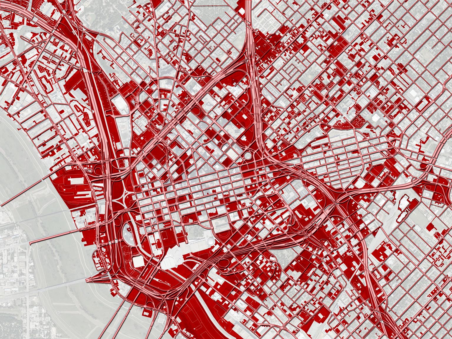
Here is a map I made 4 or 5-years ago showing the relationship of highways with "underdevelopment," which is vacant land and surface parking lots:
Fairly striking. And we're told that road widening is for economic development and growth. Only that economic development occurs primarily outside of Dallas proper so the city gets none of the benefits and all of the burden. The other issue is that the growth likely would have occurred anyway, except in this format cannibalizes from Dallas and feeds places like Useless, Farland, and Farlington*.
*Not real names. And no offense intended towards those places, but in order to survive the 21st Century, they will have to reposition themselves as more autonomous and less dependent.
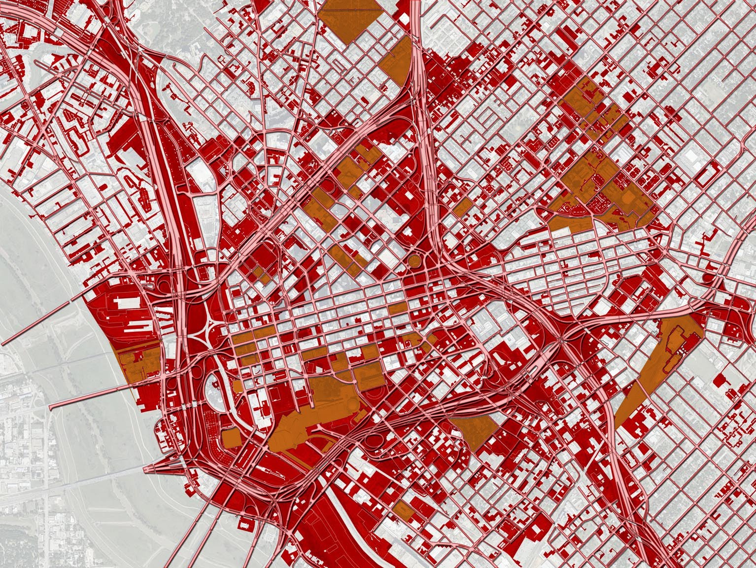
Now let's add in tax exempt entities and properties on top of the last graphic:
Orange are those properties which consist of city and federal buildings, churches, schools, some parks, and some transit-related facilities. Many of these add real value. But the larger point is that they are situated on land the market deems not terribly suitable for anything above surface parking. Such is the highest and best use of freeway adjacent land. Land is cheap and wouldn't generate much tax revenue anyway so on goes an [insert magic bullet of revitalization].
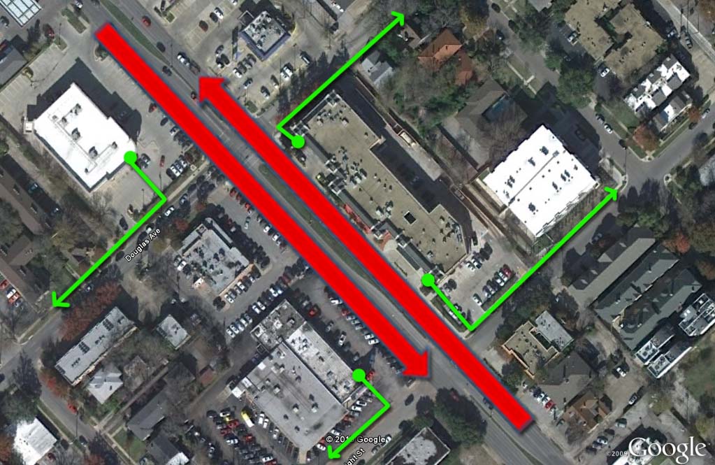
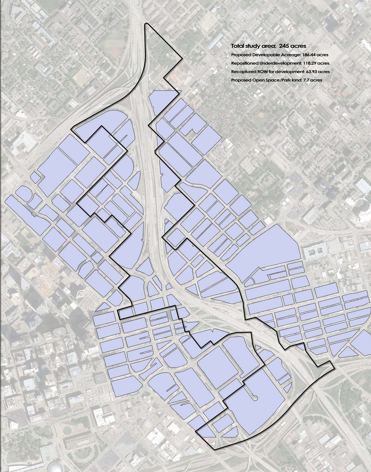
And lastly, our study area for highway segment removal, IH-345 between downtown and Deep Ellum:
This is 245 acres of downtown and downtown adjacent land that generates all of $3.5 million in tax revenue per year for the city. By removing the freeway, we could create more than 60 acres of developable land that was public right-of-way AND reposition 120+ acres of underdeveloped land.
Our most CONSERVATIVE estimate (which is preposterously conservative in terms of proposed development density and future land value - 1-story buildings and land value remains stagnant) adds 6x the amount of tax revenue per year and IIRC about $750M in new investment. Our more ambitious numbers approach $100 million in tax revenue per year and $6 billion in total investment. All by removing a liability and restitching the grid. Expect our full report and proposal with all sourcing, metrics, and methodology within the next few weeks.
Reader of this here blog has decided to pick up the cause of freeway removal in Dallas, starting a facebook page Save Downtown Dallas: Tear Out Central Expressway. Go like it, if you like of course. I did.
Houston doesn't have this problem since they annex everything around them. On the other hand, if we were to only flip the mindset a bit, we can see this as an advantage. Those people beyond Dallas aren't voting in Dallas elections. Why are making transportation decisions on behalf of people who don't live in Dallas?
Because of Dallas's "landlocked" nature, we actually could use far more competition between DFW cities. I know, I know, NCTCOG is hailed all the time as a model of regional governance. For the most part, because they do two things, 1) elicit cooperation amongst all the cities within the interconnected beyond-boundaries economy that this is, and 2) get federal money. They are quite excellent at 2. Unfortunately, that can mean freeways/road expansion projects.
To quote Namond Bryce/Senator Clay Davis, "I'll take any muh-effers money if they givin' it away." That's Dallas. A corrupt politician and the 8th grade equivalent of one. Of course, I'm making a parallel to a fictional television series, but is it so fictional?
Any effort to get more freeways/expand road capacity undermines all efforts at expanding scope/efficacy of other forms of transportation. Rail, bikes, new kicks for pedestrians become little more than niceties used primarily by the indigent as everybody else thinks life is just fine...as gas climbs to $5/gallon. What then?
Isn't it in Dallas's best interest to look after its citizenry? To make the city more livable by getting rid of the very things that chased everybody out? Everybody will say, "OMG businesses will all die," just like they did in Copenhagen when they started taking cars off of streets. Or as they warned Vancouver when they wouldn't let freeways get built in the first place. Or when Portland or San Francisco began removing freeways from their inner-city. Do you think any of those places regrets those decisions? Do you think they said, "man, I sure hope Oakland and San Jose don't mind."
Then they'll say, "OMG traffic will be a nightmare!" And it very well might for a few days, maybe a week. Then you know what happens? That traffic begins to find other ways around. If it was to go to work, they might take the train instead. If it was to go shopping at an outlet, perhaps they do it online. If it was to drive somewhere that had to be driven, perhaps they find another route or go somewhere closer.
An amazing thing happens when you cut road capacity. Traffic demand falls with it. It doesn't just merely re-route. But some percentage disappears. This doesn't mean the economy shuts down and we all lock ourselves in our emergency shelters eating yankee beans by candlelight waiting for Armageddon to subside. Here is an excerpt for Tom Vanderbilt's Traffic:
If you do not believe that new roads bring new drivers (ed. note.: as the author explains in the previous section this is a concept known as "induced demand"), consider what happens when roads are taken away. Surely all the traffic must simply divert to other roads, no? In the short-term, perhaps, but over time the total level of traffic actually drops. In a study of what they called "disappearing traffic," a team of British researchers looked at a broad list of projects in England and elsewhere where roads had been taken away either for construction or by design. Predictably, traffic flows dropped at the affected area. Most of the time, though, the increase in traffic on alternative routes was nowhere near the traffic "lost" on the affected roads.
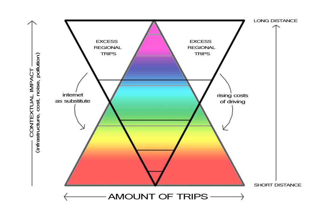
As I wrote the other day, in happily pointing out that Joel Kotkin has zero clue what he's talking about suggesting that the internet replaces walkability (which makes no logical sense whatsoever), the internet along with price corrections to driving as a way of life will be replaced by more affordable, more efficient, and FASTER forms of interconnectivity: 1) internet replaces many regional(and longer) connections, and 2) spatial relocation to walkability replaces others. Thus converting the abandoned city to a lively city:
Here is what will happen if in fact we were to remove one of the many freeways carving up our city like an Easter ham. We would open up hundreds of acres of land for development, which means increased affordability as well as increased livability (ie more walkable urbanism). We would have an increased tax base and the ability to provide more services, particularly at a neighborhood level. Businesses wouldn't shy away from Dallas, but instead say, "hey, they've got something going on there," and look to relocate here without having to fork over tax breaks to get them.
Quality of life is going to be the driver of the 21st century economy. Job growth will come from the businesses looking to locate in areas precisely because of the area, the quality of life, and to be near all of the other similarly-minded people doing similar constructive things.
And as far as the suburbs go. This would be the best thing possible for them as well, like 30-year old children still living at home. At some point ya gotta cut the cord. They wouldn't be so dependent upon the core city. They would have to become more resilient, more walkable, more diverse, more independent themselves.
DART needs the ridership. The state needs to spend less on infrastructure (and certainly wouldn't mind unloading its biggest asset (Right-of-way) in order to balance its own budgetary crisis). Cities need tax base. And citizens could probably handle far less Vehicle Miles Traveled and the associated gas/ownership/maintenance costs that go along with them.
Lucky for us, we have the perfect storm of opportunity and economics swirling around us to make it happen. If we were only willing to piss off our neighbors a bit. I'm sure they'll forgive us.
If I was to try and calculate the amount of potential investment, I would start from the Brown University study pointing out that every urban freeway leads to a population loss of about 17% of the total city's population, and work backwards from there. Without the freeway, theoretically, that 17% would want to return (obviously not the same people) and would need a place to live. In a city of 1 million people that is 170,000 people(!).
Optimistically assuming that a freeway removal project could capture all of that population (re)growth, would immediately reposition large areas of the city. For example, if RL Thornton (30) was removed from between Stemmons Highway (35/Mixmaster) and loop 12, that immediately increases the quality of life and therefore value of 1) downtown, 2) cedars, 3) Deep Ellum, 4) Fair Park, 5) and much of the rest of East and South Dallas.
For the sake of round numbers, let's say those 170,000 move in at an average house/construction cost of $100,000. That equates immediately to $17 billion (once again !!). Not to mention the amount of taxes those people would pay to the City of Dallas, imbuing its coffers and ability to maintain itself.
Those 170,000 would also now be in more location-efficient housing, meaning less transportation costs for them, likely more transit riders to help DART's numbers, would need local retail services so there would need to be auxiliary commercial investment (ideally small, local business and the multiplier effect therein), and would likely not have to spend so much on gasoline/cars which can mean upwards of $7,000 per year in their pocket that they can choose to do whatever they please with it: invest it, save it, or do the really American thing and blow it all in Vegas.
The point of all this, is that the economics of cities get really complicated to the point of being nigh incalculable, if you want to do them right. So there is a certain amount of faith involved, particularly in rejecting the numbers that are used, because those tend to be so oversimplified as to be useless. We use them anyway and as statistics are often mere abstractions, we end up with a similar abstraction of a city.
FYI - this draft has been sitting in my edit posts unpublished for 11 months. Time to bring it to the light of day:
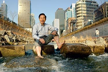
It is amazing what can happen when you listen to the people. In one case, the former mayor of Seoul, South Korea made his career pretty much entirely by making his city more livable for its citizens. That's the kind of popularity that carries mayors into presidencies, as it did for Lee Myung-Bak, now the President of South Korea.
The two biggest legacies he left Seoul with after he left for, uh Seoul, were the Seoul Forest, a large urban park on land that was rendered rather useless by overbuilding of roads/highways and the Cheonggyecheon, a stream-turned freeway-returned to public park and accessible water course. This is what I want to focus on, because 1) it is close to my heart, and 2) it is much more far-reaching in its positive effect on the city and the former mayor's legacy.
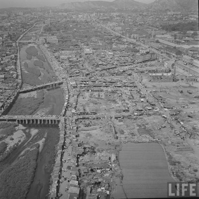
Like many cities, Seoul originated on the calm waters of a crosswords of pathway and waterway. As the city grew substantially over the next millennia, they reached a decision point, maintain the waters under the principles of feng shui and use it like a toilet or relocate it to allow for the growing population. Naturally (we all poop right?), they chose the latter. The clear water stream became the not-so clean water.
It was gross, or at least, I'm sure it was as any river used for human effluent might be. When the way towards a happily ever after future was found (cars/highways), the Koreans naturally covered up the stream forever to be entombed in what else, an elevated freeway through the heart of Seoul. In the 70's, the new highway was hailed as a monument to progress, Seoul was keeping up with the West, all of whom were leaving behind poor backwoods Vancouver, which wasn't building any freeways. Losers. Let's all laugh at what a backwoods town Vancouver will be in the 21st century. snicker snicker.
Image from Preservenet.
Shockingly, this had its own consequences, i.e. ripping apart the vulnerable, formal and informal connective tissues that make up cities and all of the implicit advantages this connectivity brings. I've often used the brain as a metaphor for cities and vice versa. Reading the miraculous recovery of Gabrielle Giffords, I came across this:
"But it also damages neurons that don't lie directly in its path, because it is trailed by a pressure wave that transfers the energy of the bullet into the surrounding brain tissue.
In brains, like in freely accessible cities, everywhere is connected to everywhere, however some parts are farther and more difficult to connect than others. Within organic, self-organizing cities, there usually is a reason for this. A bullet (or highway) slicing through it severs the complexity of the millions of potential connections for the prioritization of only point A to only point B.
Noise and congestion created by car traffic had deteriorated quality of life, polluted the air. Congestion is not necessarily a bad thing. Just when it means car congestion, which usually has no recourse to get out of it. Pedestrians are more nimble and can simply leave a crowded pedestrian zone. Cars, you're stuck on that freeway, idling your time, car and spewing dollars, carbon monoxide into the thin air.
Along came Myung-Bak, a wonderkid, a CEO (of Hyundai) by the age of 35 decided to run for Mayor of Seoul on a platform of removing the freeway and restoring the city to its people. The larger metaphor here, is that we no longer need the reactionary impulses towards industrialization's dirtying of cities. Cities can be clean and safe these days, so why run from the problems (and the inherent, associated advantages of cities) you abandoned?
Myung-Bak was swept into office aloft this populist wave. However, as with all new ideas and/or counters to the status quo and conventional wisdom, the idea of removing a freeway "vital to business" or whatever was treated with skepticism. Probably a similar skepticism that doubted Copenhagen going car-free for much of its central city. Lesson 1: this is natural. Business is ALWAYS acutely adapted to status quo (as it should be - if not, it would likely fail). It generally is allergic to change unless the benefits of that change are immediately understood.
The new mayor's plan faced all of the same arguments, "omg traffic! businesses will die...and omg traffic!!" Any new idea requires incredible leadership and initiative armed with foresight.
To ensure success, Seoul set performance goals albeit entirely unrealistic ones - 50% reduction in private vehicle usage. It doesn't really matter if they hit that goal, but it gives them the stars in hopes they hit the moon. Adding road capacity has never worked in addressing traffic congestion, so they sought to reduce demand.
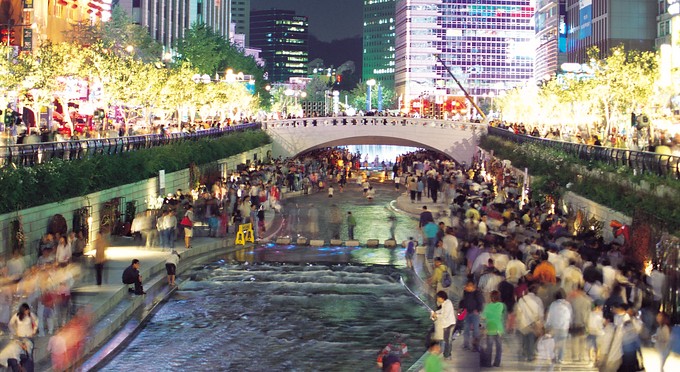
I have seen project costs ranging from $200 million to $600 million, presumably dependent upon what is actually counted. While that seems like quite a bit for something that adds through subtraction, the economic impact has been substantial, around $2 billion in private investment since construction completed in 2005. That's good public investment, leveraging public capital for increased private capital AND improving quality of life while doing so. It is easy to see how it this happens when you factor in all of the property that is 1) tied up as freeway ROW, and 2) all of the auxiliary and adjacent properties that are negatively affected by freeways.
The spin-off effects didn't stop there, as the New York Times wrote in 2007:
"The man chosen as South Korea’s next president in Wednesday’s election owes much of his victory to a wildly successful project he completed as this city’s mayor: the restoration in 2005 of a paved-over, four-mile stream in downtown Seoul, over which an ugly highway had been built during the growth-at-all-cost 1970s. The new stream became a Central Park-like gathering place here, tapped into a growing national emphasis on quality of life and immediately made the mayor, Lee Myung-bak, a top presidential contender."
Fundamentally, what tearing out the freeway did, was restore all of the neurons that exist within a complex, functional urban center. In contrast, the efforts to revitalize downtown Dallas, more resemble trying to win the Olympic biathlon while missing every single target and having to ski 20 repetitive penalty laps. It's amazing how magic bullets never seem to hit the target. I'll advise the USOC.
Freeways reduce intersection density, which operates as a substitute for network density. As Bill Hillier is showing with his studies of London, that there is a direct relationship between property values and connectivity in systems (even if it isn't immediately bared out, eventually it will be). To counteract the negative impact of freeways because we falsely assume we would lose connectivity without them, we too often settle for weak compromises like "emerald necklaces" which is little more than greening up areas no one goes to nor wants to be in. We're expending costs to overcome costs, trying to make four left turns just to go straight because there is a road block rather than removing the road block.
Image from Korea Times: Some columns were retained as monuments.
Another issue to be addressed is the notion of freeways as city walls. In some ways, that is correct as they are barriers to connectivity, but the effects of the analogy are misplaced. City walls forced dense development, a coerced sociopetality. You had to stay within them to ensure safety. Highways are sociofugal. They fling people away directly (because you can drive fast and travel far distances) and indirectly (as in, who would ever want to live on one?).
Removing the freeway takes a repellent force and creates an attractor, a center of gravity, a necessity for downtowns. Today, 90,000 pedestrians go to the new park in the center of Seoul, each day. 50 million have visited the new riverfront park in five years. It has become the center of Seoul, and by extension all of South Korea. Any city in the history of the world is polycentric, in that there are many centers of commerce and activity, that organize hierarchically based on access and popularity. Like any system, they both compete and cooperate.
However, the downtowns in the Sun Belt have been competitively knocked down several pegs, in a flatter, less hierarchical competition with suburban highway office parks. The result is reduced competitive advantage of urbanism, of interconnectivity that, as physicist Geoffrey West has shown is an increase in economic development by 115% for every doubling of population size. Sun Belt cities do poorly by these metrics precisely because of their disconnection. They have all of the problems associated with big city population but none of the advantages.
For a city to function, like a brain, intelligently, it has to be intensely interconnected so that the "cells" can communicate more intelligently, efficiently, and adaptively producing a more resilient system. The cells are the buildings and freely moving in and out of them is functionally reduced every time you have to get on a freeway and drive several exits. While highways are important connections on a macro level from city to city, within cities they are a barrier to this higher level of interconnectivity.
The modern city is no longer defined by high speeds and freeways. That TomorrowLand fantasy turns out to be Never Never Land. As is the course of human events, we eventually learn from our mistakes, usually after all other avenues are exhausted. High speed auto traffic is fine between cities but not within them. However, the attempt to increase speeds rarely ends up actually doing so. As the Jevon's paradox suggests when applied to cars/driving/mobility, making driving easier increases the amount of drivers thereby making it more difficult. The future cities, the cities competing for global talent are focusing on livability. Tearing out inner-city freeways is the profitable solution, as Seoul has proven. The only thing freeways make more livable is someplace else.
But it’s more of a spur than an essential part of the interstate system. And its consequences have been grim. Old Claiborne Avenue, with its generous, oak-shaded median, a walkable neighborhood center with a history of picnics, Mardi Gras parades and black marching bands, literally disappeared under the broad new route that backers claimed would carry traffic and prosperity into downtown New Orleans.
The number of businesses along the freeway’s path literally collapsed — from 132 in 1960 to 35 in 2000. Poverty and decay reigned, the stark expressway section creating a hostile no-man’s land around it.
Today the Claiborne expressway “is an aging interstate… nearing the end of its useful life and beginning to deteriorate,” requiring frequent maintenance and “possibly reconstruction to carry traffic safely,” according to the exhaustive new report advocating its demolition, issued jointly by CNU and the local Claiborne Corridor Improvement Association.
It would make no sense, the report suggests, to spend the $50 million the Federal Highway Administration’s national bridge inventory says might be needed just to repair or replace the Claiborne expressway’s seriously decayed interchange ramps.
In Milwaukee, where Jon Norquist — then mayor, now CNU president — led the successful effort to dismantle the Park East Freeway, the bill for teardown and putting a surface street system in place was just $30 million, compared to $80 million to rebuild the freeway.
In fact, teardowns, at least on unessential interstate links, may start looking more attractive nationally as the U.S. Department of Transportation struggles to come up with sufficient maintenance budgets to keep up the elevated freeways passing their effective 50-year lifespan point.
Funny. These are all the same arguments I've been making to strip out the intracity freeways in Dallas. It's the economy stupid. Highways, while necessary in linking regional and interstate economies are actually destructive locally. This is why in most sane and/or European cities highways are considered a LULU or Locally Undesirable Land Use, meaning they come nowhere near residential areas, remaining on the peripheral edge of the entire city where junctions lead to boulevards which may then enter the actual, functional fabric of the city and local, interconnected economies.
Highway adjacencies = underperforming properties.
Tearing out freeways are 1) cheaper than maintaining them, 2) removes fiscal burden from crippled state and DOT budgets, and 3) leads to qualitative improvement of local real estate. It only makes sense that a sociofugal design element such as freeways also flings investment far away from it, leading to decay all along it. Attract people, attract investment. This is a simple formula. It is a shame the dialogue has been so poisoned by the stupid and/or corrupt. The comfort of the familiar, a trap it is.
Despite protests from predominately African-American neighborhood residents and business owners, construction of Interstate 10 erased the oak-lined avenue that had been a strolling route for Louis Armstrong and other famed New Orleanians. The 132 businesses the street supported in 1960 shrank to 35 by 2000. Restoring the boulevard offers an opportunity to fix an oppressive mistake and create rich soil for growing diverse, locally owned businesses, as well as creating jobs for people native to this community. It is the best way to make the corridor a prized asset that brings hope to Tremé and lower Mid-City and works for all of New Orleans.
Enough press and these things become runaway trains and that is a good thing. ------------------------- Take this for what it is worth, but a new Gallup poll shows that the longer your commute is, the lower your physical and mental well-being:
The results imply that many employers may need to reevaluate their options for helping workers manage those effects, particularly in light of the costs associated with low wellbeing. Those who are hesitant to allow telecommuting, for example, may need to consider balancing the physical and emotional toll of long commutes against the social benefits of having employees together in the workplace. Employers should also recognize that it's not just the time lost in commuting that may have adverse effects. Particularly in tough economic times, commuting expenses -- whether they go to gas and parking or mass transit fees -- may contribute to elevated worry levels. Helping defray those costs may help employees make the long trek to and from work with greater peace of mind.
I tend to ignore polls like these, and prefer reality based statistics such as measurable incidents. When people are polled and know they are being polled, their answers are often consciously adjusted to what they think the inquisitor wants to hear.
With that said, I do generally agree with their conclusions. Although with very little housing supply in and around downtown areas, lack of supply inflates housing price. Of course, if we were to individually measure Housing + Transportation costs accurately and consciously, we would probably see smarter decisions on where to live. ------------------------ Yours truly gets reviewed by a local blogger Metroplexian in a post called Loser Cruiser. I'm not sure if I'm the loser:
My only real criticism of Mr. Kennedy's blog is that he lives in downtown. He works in downtown...Most of us can't swing living and working in downtown Dallas. We have to live where most of the Metroplex lives, in the goddamn suburbs!
The rest of the blog gets into a personal account of the travails riding DART and its many limitations. It is worth the read.
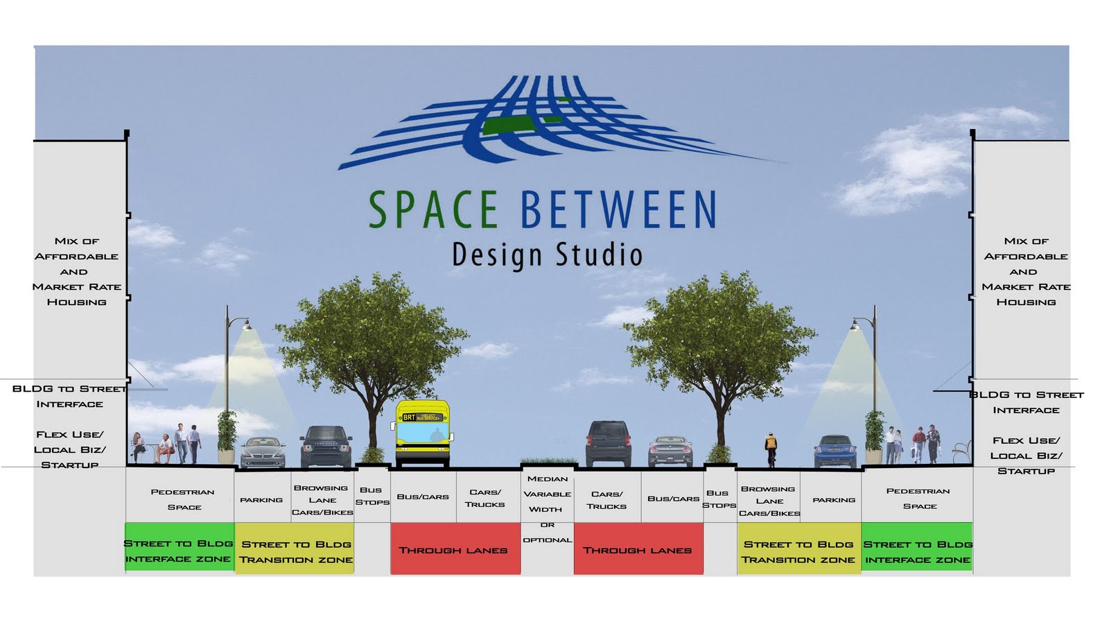
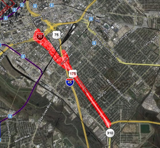
In the heat of the discussion of whether 175 should go transition from a dangerous highway that severed local connections to a 6-lane boulevard or a 4-lane boulevard, I decided to propose a compromise where the 5th and 6th lanes would be shared bike/car browsing lanes and at lower speeds than the 4-primary travel lanes, thus creating a calmer interface between LINK and PLACE:
Click graphic to mega-size
One of the key issues in planning these days is making sure buildings interface with the sidewalks, with permeable buildings made possible often through ground floor uses that are open to the street that are typically retail or small office, have plenty of clear glass to accentuate the visual permeability, and multiple entries along the building wall.
What we have still been very bad about is ensuring that street designs do the same, that they also interface with private development sites. Our arterials are the perfect spot for this kind of redesign, 1) because they are already very wide and 2) density of development WANTS to align with density of movement. However, this doesn't happen because our arterials are not designed in a way to promote density, to interact with the kind of mixed-use development that makes for great cities (and generates the most tax base).
European cities have been much better about doing this than we have. The above section is modeled after a typical European boulevard. You'll see the traffic with the highest rate of speed is towards the center and away from more vulnerable forms of movement such as bikes and pedestrians. The highest speed lane is the middle most, where the lane next to it incorporates a bus lane to be shared with traffic. Because the buses frequently stop, it is closer to the transition zone, which is then shown in yellow. The yellow zone is for medium speed to slow speed traffic (15- to 25-mph) and includes parallel parking as well as a shared travel lane between cars and bikes. Lastly, is the green zone, which is the pedestrian realm, for the slowest, most vulnerable of movement, but also where there is the most interaction between street space and access to private uses.
The one glaring Con with this scheme is the width of the Right-of-way. It doesn't recapture a great deal of land that can then be used to leverage private investment whereas the 4-lane scheme does. However, this scheme DOES create a better interface between traffic flow and potential development along it than would the 4-lane scheme.
[edit 2] Just checked out the highway section and it looks like the ROW is about 210' give or take. The street section above is 130' give or take which would leave 40' in depth on both sides to roll into potential private development.
Other little details: the new street could probably use a new name (edit: nevermind - just noticed that the Cesar Chavez renaming extends all the way to the curve) and the graphic doesn't include lighting in the center median. I think there is also a good opportunity to make this central street lighting a sculptural, iconic element for a great street that makes an emphatic statement for the City and South Dallas.
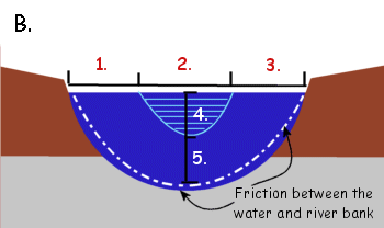
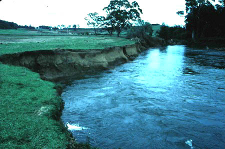
[edit 3] If you've been reading this blog for any period of time, you know that I like to draw analogies from various biological sciences to explain various elements of the urban puzzle and occasionally apply the principles to urban design. In many ways, the new section dictated by speed and comprehensively looking at all forms of traffic including bikes, pedestrians, buses, driving to park, and parking, operates in many ways like a stream section where the fastest flow is to the center:
The fastest flow in this stream section is in the area labeled 4. The slowest is in five, but depth doesn't really apply, unless you want to show a street section with a subway running below it, I suppose. As many fishermen can probably tell you, the areas just below the surface towards the bank, are the areas with highest degree of biodiversity. This is where life happens, where water eddies, gathers, spins, and dances along the banks and there is some interaction between bank soil and water, people and buildings.
This is almost good news all around. DMN has the story of money intended for the completely unnecessary Trinity Toll Road to be shifted to de-highwaying 175 through South Dallas. Well, if we need to spend money on roads, might as well be to downgrade them rather than new capacity. As with many roads, new infrastructure (in this case 175) was thought to be the necessary investment for bringing jobs and investment to certain areas. When it is the wrong kind of infrastructure, the kind that severs community ties, local economies, and hinders real estate, that is hardly the formula for new investment.
Except apparently we can't get it all right. It looks like the arbitrary traffic formulas will win out and the road will be 6 lanes instead of the 4 that it should be.
"Traffic volumes and conformity dictate the need for six lanes versus four lanes," agency spokeswoman Cynthia White said. "The City of Dallas supports six lanes."
Conformity with what? TxDOT now has Context-Sensitive Design Manual. Dallas now has Complete Street Initiative in place. Why not conform to those? Actually leverage real investment in the part of town that needs it. After speaking with people involved with the bike plan, while doing field work, they reported that South Dallas is littered with 6-lane arterials that get maybe 5,000 cars a day. The formulas are above reproach.
Now if we wanted to make it 4 travel and 2 cycle tracks, to build expanding the burgeoning bike culture in Oak Cliff to South Dallas, than we'd be getting somewhere. If it goes to 6, I predict within ten years we end up taking it down to 4.
New Orleans and St. Louis are ready to start getting serious about intra-city freeway removal. Why? Because hitting rock bottom and exhausting all other hopeful yet feeble and misguided attempts towards revitalization have failed and shocker! it turns out that winding back the very siphons of vitality:
First, New Orleans and the I-70 expressway:
A small fraction of drivers — less than 20 percent — use the Claiborne Expressway as a through route between the east and west portions of the region and beyond. With most through traffic using I-610, the Claiborne I-10’s “use does not match the intended function of an interstate highway,” concludes the report.
Point being that it is mostly used as a local route and a freeway is hardly the best design for local connections. As I've said, freeways are 1) a LULU or locally undesirable land use and should remain outside of the neighborhood fabric, and 2) are only economically beneficial in linking metropolitan economies, ie Houston Metro to the DFW Metroplex, but are disadvantageous within the actual cities themselves, as St. Louis blogger points out here:
Two adjacent high-density neighborhoods will be richer than either could be alone because businesses at the edge of each neighborhood will be enriched by pedestrian traffic from the other. Driving a freeway through the middle of a healthy urban neighborhood not only destroys thousands of homes, it rips apart tightly integrated neighborhoods. Pedestrians rarely walk across freeways, so businesses near a new freeway are immediately deprived of half their customers. Similarly, residents near a new freeway lose access to half the businesses near them. The area along the freeway becomes what Jacobs calls a “border vaccuum” and goes into a kind of death spiral: because it contains little pedestrian traffic, businesses there don’t succeed. And because there are no interesting businesses there, even fewer people go there, which hurts the sales of businesses further from the freeway. The harms from such a freeway extends for blocks on either side.
We saw freeways in Germany during and after the war and thought, by golly those are a great idea! Military and highway spending did wonders for bringing Weimar Germany out of its deep, deep depression, we can do the same! And then went overboard and never stopped spending looking for what ultimately turned out to be increasingly damaging ways to insert freeways into the daily lives of all of us. It made a few people very wealthy and they are not eagerly awaiting this turning tide of popular perception.
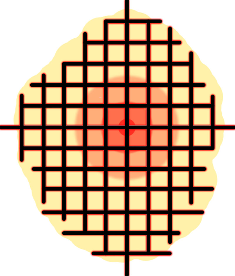
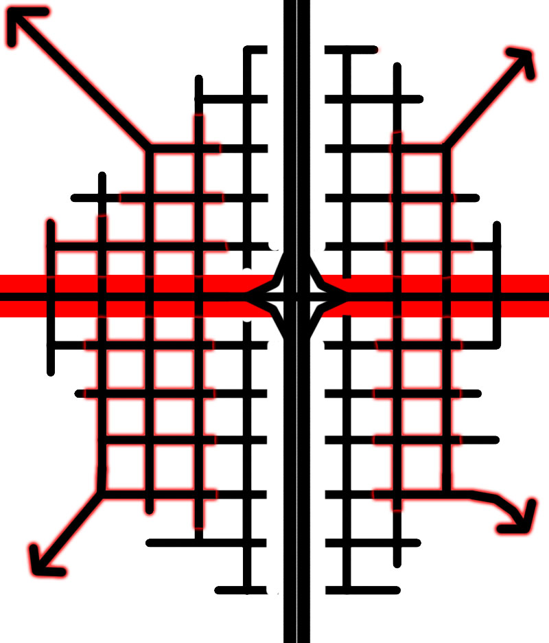
Let's go through this diagrammatically, shall we:
First, we have a typical American gridiron city laid out for real estate simplicity and flat midwestern geography.
The center of gravity forms at the crossroads, the main and main intersection. Businesses and density can reliably locate along these main streets. The density, in a livable, fully functioning city is merely the byproduct of desirability and there is an accurate and direct relationship between the two.
Since the entire network is interconnected, like an electricity grid, the entire system is "energized" or alive.
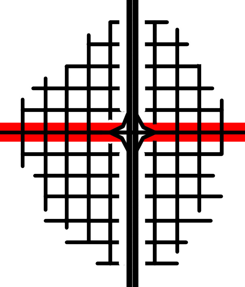
Now we cut a highway through it for the sake of "interconnection" or jobs or just spending money for the sake of circulating it. We're not generating any real value because assuming this connection is necessary, it could still happen to the periphery of the city like any other LULU.
The red bar is essentially the "port" system for the amount of cars delivered along a dendritic, overly-hierarchical road system, aka parking. This becomes your typical strip retail area. Think of this like a natural stream and ecosystem that all of a sudden is exposed to a new runoff and drainage source. The shear volume erodes the stream banks and slowly but surely kills the ecosystem.
Where the full connected system once energized the entire network, now we only have pockets of connections. One part of town no longer plays a part in strengthening another. They are left to whither away. Durability of the entire network is diminished.
Because desirability is now diminished, people flee. Like in the streambank, life decides "hey, I can find a better, possible life somewhere else." Residents moves outward to further isolated and disconnected pockets that have very little embedded predictable retention of value or durability. Similarly, businesses try to locate for predictable customer base, but that proves impossible as the target location is always moving further and further out as more roads are constructed, and new shopping centers pop up each decade, also further out.
The end result is "anti-city" or places that are worth less than the sum of parts. Our cities and individual properties need to be part of an interconnected larger system in order to be greater than that sum of parts. --------------------------------- Lastly, and relatedly:
Lead researcher, James Woodcock said, "This research confirms that is not just exercising hard that is good for you but even moderate everyday activities, like walking and cycling, can have major health benefits. Just walking to the shops or walking the children to school can lengthen your life -- as well as bringing other benefits for well-being and the environment."
But dude, I can't cross that highway without playing a very real game of frogger with my life. And kids live so far from their schools they now must be bussed from all over creation. More negative external outgrowths of anti-city inertia. Now about those school budgets...
I came across a tweet yesterday by Richardson blogger Mark Steger that I want to address because it is both right and wrong. And because it displays a common misconception of the conventional wisdom. Here is the tweet that may or may not have been in response to one of my twitter rants:
Travel old Route 66 today and see all the towns that died when the Interstate bypassed them. Then you'll know why cities don't cut the cord.
I shouldn't complain that blaming highway bypasses for the death of small towns because for a long time I believed the same thing...until I started to think about it yesterday. Mark is right that the highway bypass killed those small towns, but wrong that it is still relevant today, at least to big cities.
I would argue that the highway bypasses didn't kill towns as much as they were probably already doomed to some extent. Our remorse is little more than nostalgia.
The old highways, before the super highways, were the single lifeline of a 20th century small town. Each turned into the "Main Street" as it passed through town. Before that towns sprung up all over the country along railroad lines linking the country from coast to coast. This dates back to antiquity where trading posts emerged at cross roads between settlements.
The difference between then and now is that the world is different. It is hyper mobile and getting moreso every day. We are no longer connected by one umbilical cord whether it be a railroad or an interstate. It is the human urge to connect and technology is making it possible to do so in a dozen ways including via (see what I did there?) the internet, they way you are reading these very words.
The internet also hasn't proven to be the death of cities or human interaction as many once feared. In fact, the opposite has occurred where we have shaped the internet into web 2.0 or social media making human interactions and community building all the more efficient. We've created cities and we've created the web to facilitate human interaction and INTRA-city highways are a barrier to that. Unless of course this is your kind of human interaction:
I say INTRAcity highways because INTERcity highways DO serve an important function in linking regional economies, ie Dallas to Houston. But, they also should just provide an option, much like you can fly or hopefully in the future take high speed rail from downtown Dallas to downtown Houston. We like that idea because it facilitates connections from where people are and commerce happens, the cores of cities. However, highways within cities tear apart the urban fabric, are a centrifugal force of entropy, and damage local economies.
A certain segment of the population wants human interaction, wants to be near other people. Highways prevent that and only serve those that don't. As I tweeted, they are the lifeline of the suburbs and ironically, removing them would be the best thing for brittle suburban communities dependent upon them as they leech from the core. In order to survive the next century, suburban communities will have to be able to stand alone.
Those small towns don't compare to today's modern megalopolitan economies. Today's cities are highly interconnected, highly mobile places where freeways actually make it more difficult to make our daily face to face interactions that comprise cities.
The blame we lay upon the bypasses is that they killed Main Street. Main street businesses packed up shop and moved out to the interchange in the form of big box. But people had already left. Retail follows rooftops and everybody moved outside of the towns or the cities because of debt-fueled, tax incentivized policies towards consumption of new land, new houses.
Except all of that is as ephemeral as the leaves on the trees. We have 6x as much retail per capita as does the most heavily retailed European country. All of that excess retail is going to fade away and re-cluster around population centers in order to survive. All of those homes and buildings built to last twenty years and made of little more than paper mache are going to turn to dust. We won't be replacing them with more of the same. The sun belt cities you see today, will never be seen again. We can no longer afford them and we're seeing the effect.
Our intra-city highways are a giant land bank that broke states and broke cities are sitting upon. Irony = that which bankrupted us is the biggest asset we have in restoring our wealth and prosperity.
This won't happen all at once. It would be too traumatic. Humans adapt, but we can only do so at our pace, which is why it is necessary to slowly, but incrementally implement change for the betterment of cities and the facilitation of human interaction and human need. The same much of Copenhagen didn't go car-free overnight, we will start with easy wins, narrowing highways and their interchanges. Replacing cloverleaves with development opportunities.
People will likely be fearful of the idea. In Copenhagen, local businesses yelped when change began. Businesses, as well as people, are conditioned by their context. They generally hate change. Status quo is comfortable. We're used to it.
But we need real mobility, a choice of mobility. Highways dominate our life. You can't get anywhere without them, which is precisely why losing them seems frightening. We need to replace our highway commute to work with a train ride where we CAN text or email without endangering lives. Our drive to the store with walk down a peaceful, tree-lined street; the school bus system that bankrupts our schools with an empowering bike ride.
Cities are built upon connections and the great ones have the quickest, the most expedient, the most efficient, and the most nourishing, the healthiest. Intra-city highways are the opposite of all of those.
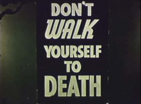
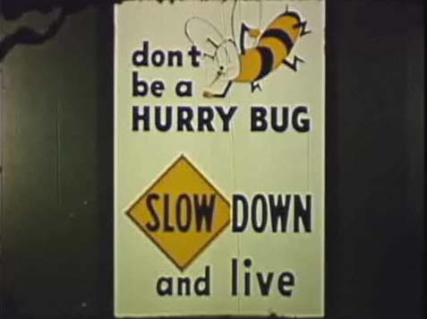
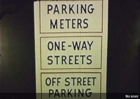
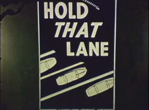
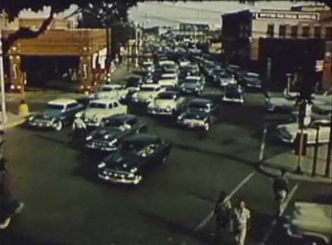
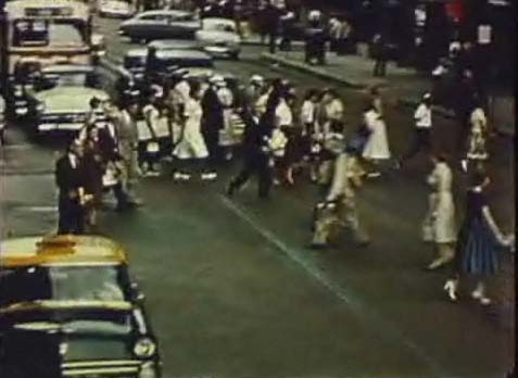
Thanks to Robert Wilonsky at the Observer for alerting me to this video from the 1950's imploring Dallas to move that traffic. It is worth the watch if only for the old video shots of 50's era D-Tex, which are pretty cool. There is no embed code with the video, so you have to go here to watch it, but I'll include some stills with general commentary.
My favorite part of the entire thing is how unaware this video and by extension transportation policy is still to this day of the logical inconsistencies underlying their theology. Got to move that traffic swiftly, BUT DON'T SPEED! Say wha?
So we design roads comfortable enough to drive at uncomfortably fast speeds then devote resources to regulation and enforcement of those streets.
To better understand this video and the policies espoused, it is important to understand the general mindset of the day. At the time, economic productivity was defined by the assembly line. Theoretically it invaded all fields including urban design. However, urban design being that it is complex is antithetical to the assembly line which requires simplicity and a vague, most likely, over-simplified notion of efficiency.
But, our theoretical models suggest we must keep building new lanes to tantalize you with the illusion of choice and that the other lane might always be moving faster than the one you are currently idling along.
So in order to distill the notion of city into simple enough terms that economic productivity theory of the day could work with, the various segments of urbanism were compartmentalized in every way possible: from single-use zoning to transportation policy, which is what we have here. the resultant system is one where each of the specialized professions and their tailored goals are in competition with one another, pulling the city in opposite directions rather than orchestrated and moving in the same direction toward a singular goal. The destination of a great city.
By doing so, they took 10,000 years of accrued awareness and understanding of urbanism and flipped it on its head favoring one-way streets, no on-street parking, road widenings described as dire necessities, and other design mechanisms to ensure that there is no "friction" impeding the efficiency of the conveyer belt of the auto-oriented assembly line. Placemaking and livability be damned.
Unfortunately, friction, convergence, choice are all necessities for cities.
Why? Their stated goal was that it was necessary to make downtown shopping work... uh, how is that working out? This is what happens when you take thousands of years of empirical evidence and throw it out the window in favor of ideological righteousness.
However, the report is right in one sense, traffic is the lifeblood, the pulse of the city. What it gets wrong is that it oversimplifies. It streamlines. It only looks at traffic from the perspective of the car. In actuality, traffic should be thought of as all forms of transit, preferably those with the least cost and greatest efficiency, walking.
The city as an assembly line does not make for more efficient cities. Universal auto-ownership does not make for more democratic cities. Cloverleaves do not make for free markets. It is all mumbo jumbo. Scientific term.
Today, rather than assembly lines and the model of economic development of early 20th century fascist countries (highway building and militarism) guiding urban policy, we are turning to new fields of study which are far more practical to how cities actually work: computing, networking, fractals, complexity, crowd sourcing, behavioralism, empiricism, etc.
For an example of how single minded transportation policy actually undermines the notion of efficient markets, we'll take a quick tour of a few roads around the City.
Lemmon Avenue. It is wide. And while it is two way, functionally it operates more as a one-way hybrid with the grass medians. Medians make for chutes, which theoretically help traffic to flow. However, flowing traffic, particularly at a high rate of speed prevents traffic from crossing. That is traffic of all forms, including pedestrians. The best you can hope for here is that some of the residents might walk from the neighborhoods adjacent to the drive-thrus. Because there is no on-street parking, it all has to happen off-street. Because it is off-street, the buildings are set back with parking in front for convenience.
Greenville Ave where Mick's and Hurricane Grill once stood. /Pours liquor.
Greenville is an improvement over Lemmon, but it isn't perfect. The scale of the street allows for a clustering of commercial space all along Greenville rather than the linear "strip" like on Lemmon. There is some parking, but it doesn't define the space nor disconnect it from the neighborhood or the synergistic effects of the adjacent buildings. Some pedestrian crossing can occur because the traffic is slowed enough by the scale of buildings and activity on the sidewalks providing friction. Any higher rate of speed here and the sense of place is destroyed.
Side note: keep this episode of South Park in mind next time you are sitting at the Blue Goose and a Harley rides by, over and over and over again. Braahhh-br-br-br-br-br...
Lastly, the extreme example. The three-block stretch of Main Street. The actual beating heart of downtown Dallas that traffic engineers nearly extinguished. Driving on it is actually a hassle...which allows for closer, more efficient connections to be made. Why? Because the nature of the street favors pedestrianism to the point of jaywalking, all of the connections made between source and destination: office to restaurant, office to office, home to bar, bar to back home (forgot the circuitous, stumbly route).
In this way the strict goal of moving cars undermines the viscosity of connecting people to destinations. Roads become barriers to connectivity, which themselves become undesirable to be in, to live on, or to walk along (or more importantly, across).
Once that occurs, the roads become repellent forces while placemaking and economic efficiency requires magnetic forces, things people want to be around. Why economic efficiency? Because of distance and the cost of energy to traverse that distance, which you, the consumer, bears.
Furthermore, each of the green lines represent (virtually) energy nil interactions compared to the drive-to scenario. Most intra-city destinations are ones that could occur without getting in a car or on a highway. For example, the average Roman citizen can take care of all of their daily needs without a car. Having one is a luxury. You can if you choose and can afford it. On the other hand, in Dallas, you MUST have one.
The delta between energy spent in one scenario vs. the other becomes the cost or tax for every single interaction we have. Every connection, takes car ownership, maintenance, gasoline, and the taxes to cover road construction, maintenance, and eventual widening of roads. All costs externalized onto you. In that our cities are the physical manifestations of our economies, the local economy organized around highways, arterials, and car ownership is the manifestation of a pyramid scheme.
To put it into perspective, the average American drives 12,000 miles/year. While it is difficult to find exact numbers, there is some data suggesting that 75-80% of all trips are less than 5 miles. Without knowing how long the other trips are, or the purpose of these trips, it is difficult distill these numbers down further.
So for simplicity's sake, let's say that with a different, more walkable city form, we could reduce the amount each of us drives by half. That is 6,000 miles saved accomplishing the same amount of trips. Mobility isn't reduced. It is improved via better urban design. 6,000 miles in a car with average mpg of 20, and $3/gallon gas, that comes out to $1,000 per person/per year saved. In a City of 1,000,000 people, that is $1 billion/year still in the local economy.
Of course, this also doesn't count the reduced infrastructure and tax burden necessary to support said excess infrastructure (or the band-aids for those mistakes) or the long-term costs of pollution, health effects, traffic collisions, or reduced productivity due to car-traffic jams, the stroke in a car-oriented economy.
As Mumford says, just make cities for lovers and friends. Ignore car-oriented theology and focus on placemaking. Want to be a world class city, become the most walkable city... it will also stimulate the economy exponentially.
Alright. Let me first get this out of the way. A park is rarely a bad thing for a city. I can't stress that enough. People want them. They connect the City with a glimpse of nature, a spot of free-form recreation, and a breath of fresh air.
On the other hand, too many parks and open space can be wasteful and a drain if they aren't well appropriated, maintained, or scaled to the neighborhood or region which they serve. One quick example, was the downtown parks plan.
In my opinion, it did little more than fill most of the "openings" aka surface parking lots or vacant sites of downtown as parks. It gave little thought to how it could leverage further private investment or how the City could purchase a property and turn it into an urban scaled plaza and privately-invested new residential (of whatever affordability level) to increase the number of residents, perceived degree of safety, and overall prestige of the City of Dallas. In other words, how does the plan contribute to the Livability Hierarchy? Instead, it was a plea for "parks, parks, parks" much the way cookie monster might ask for his favored morsel or Lil' Jon might yearn for his (which are really one and the same).
Simply put, it was the type of "thinking in a silo" that created sprawl, sprawled cities, and desolate cities in the first place, despite the best of intentions. It was about parks and not about parks and people or parks and city, where parks are an integral part of the city's infrastructure much the way transportation and development are all interlinked.
With that said, I came across this outlandish claim that Woodall Rogers Deck Park will "be like ocean front property." I know it is the local modus operandi to label everything and anything new around here as "world class" despite any and all evidence to the contrary, but this just might take the cookie, err cake. Don't bust out the surfboard and sex wax just yet.
Why? Because we think of these things in a bubble without regard to their context. The Winspear is nice, but what is around it?
The Woodall Rogers Deck Park is a great thing for this City and its design in absence of the complete removal of the freeway is the best (well, 2nd best possible) solution. But Bryant Park isn't great without Gramercy. Piazza Navona without Centro Storico. Want to be a World Class City? Yes, that is the competition.
This post isn't intended to poo-poo the park, but remind us that the work isn't yet finished.
When thinking about parks (or anything in isolation) in terms of ROI (Return on Investment) things get a bit tricky. First, parks like roads are never expected to be fully self-sufficient. Can we make them that way? Sure, but largely their returns are either enumerable, incalculable, or externalized. There is too much subjectivity floating around to accurately derive an input. How do you value clean air or water compared to me? How important is walkable urbanism?
I'll have to track down the graduate thesis from MIT that I have saved floating around on this here computer, but it showed a 24% increase in land values of properties within 300 feet of parks. From memory, I believe that leveraged increment decreased gradually to about 10% bump for 800 feet from the park.
So what's the problem? As I have pointed out before, the area around the Deck Park is largely built out but a few vacant properties immediately to the North and the Arts District to the South. And it is likely to sit that way given the high land value, the saturated high end residential market and flat, probably over supplied office markets. Eventually, those blocks will fill in and the new (and existing) users will need open space to stretch their legs, but I don't expect a rush of anything new in that area for some time.
Well then, what "externalized" benefits will there be? Well, it is a park so it will be used for recreation, festivities, and enjoyment, but for the most part will function as the neighborhood park for LoMac, precisely the kind of place that is like a jumbled puzzle without a piece yet put in place. Urbanism is an assembled puzzle. The pieces come together to form a new picture, something greater than the sum of the parts. Simple analogy, I know, but cities are actually remarkably simple things when you clear out the mental flotsam and visual jetsam.
LoMac has a highway, a park slapped on top, an incomprehensible and impossible to navigate set of anti-urban spaghetti of roads, and a lot of density with no urbanity. In sum, it is precisely the "urban" by-product of silo-ized attempts at urbanism. You get the government you deserve, and the city as well, which is why my money would be in areas set to rise, not those already at their peak.
Since the area is almost fully built out, Woodall Rogers Deck Park might be the cherry on top of the sundae. Except the ice cream is on the floor. The nuts are at the store and the chocolate sauce is all over the kids face with his filthy hand stuck in the jar. In other words, there is still work to be done.
This might seem crazy to say since there is about to be a new park in the neighborhood, a Ritz-Carlton, and hundreds of extremely high end condos, but without broader, more comprehensive thinking about the entire area of LoMac and the park, I promise you that the area is at its peak. Other parts of the City will surpass it as desirable places to live and be as those areas get the livability equation right, which means if you own a condo there, don't expect to sell it for more than you bought it. Return on investment.
So once the park is completed and all ribbons are cut and we take a moment to pat ourselves on the back for a job well done, we can take a moment to build the sundae, the complete urban neighborhood.
So, how could it be better?
We have to think about what is outside the boundaries of the park. Despite removing a road in what I believe to be a mistake, one of the park's primary objectives is connectivity, linking downtown and uptown. Since we're disrupting vehicular connectivity, I presume we must be thinking about pedestrian connectivity only.
That is all well and good, but I don't find areas immediately to the North or South to be particularly pedestrian friendly. They are in spots, for example Flora Street, the spine of the Arts District is, but the North-South connectors are anything but. Therefore, in order to make the park successful we absolutely, positively must think about pedestrian connections to and from the park (and widening sidewalks on oversized one-way roads doesn't help).
In order to expand the Deck Park's magnetic qualities, we have to begin stripping away the impediments. We do that by mentally moving outward from the park almost as if we are walking it ourselves.
The first barrier(s) are the parallel access roads running alongside Woodall Rogers. Currently, these look and act more like highway feeders, on- and off-ramps. Mostly because they are. But they should be designed as urban streets, with textured cross-walks, countdown crosswalk signals, parallel parking, and probably narrowed to two lanes just as they are now with the construction. If a car is perturbed by the extra twenty seconds before they can get on 75 back to Plano, so be it. Do you want a more livable city? Make it safe, amenable, and attractive to pedestrians. OMG I can't speed through (insert City from Most Livable Cities list)!!!
Next, since we are hardly using Harwood anymore (correct me if I'm wrong, but that is the one that has been ripped out, right?), we should conceptually make Harwood function as a piece of the infrastructure for the park, a pedestrian welcome mat for the park reaching into both downtown and uptown. Some vehicular access must remain for the various buildings served by it, but since cars won't be using it as a connection, might as well make it serve as much "traffic" as possible: the foot and bike kind. Harwood should look and feel like an extension of the park and it deserves an exceptional design treatment allowing it to stand out all the way to Ross and McKinney.
(Side note: I would strongly recommend vertical elements at both ends of the park to block the views of the rising Leviathan like freeways.)
Lastly, and most ambitiously, a complete rethinking of the spaghetti network of roads, both north and south of the park (cloverleaf) with renewed prioritization for the pedestrian.
Think about this: how do you walk from the Ritz to the American Airlines Center?
Possible answers: - Are you crazy? - Walk? /quizzical look - I just drive or cab - Umm, I have no idea
The distance is little more than a 1/4 mile, but perceptually it might as well be miles away. All of these roads (Field, Akard, Cedar Springs, etc.) deliver traffic to other parts of the Metroplex but function as barriers to connectivity locally. If great cities are built on a foundation of great neighborhoods, wrecking areas for the sake of others further out is anti-city.
There is a rational framework intended by the original city planners beneath the illogical suburbanized road system. It doesn't even feel safe to a driver. You may be too comfortable on them because of familiarity, so drop a tourist in the area and give them directions. Panic ensues. Much like what happens everyday downtown when drivers inevitably turn down the wrong way on the preponderance of one-way roads.
The logic and intuitive wayfinding of the walkable urban grid needs to be revealed in order to unlock the value of the remaining undeveloped and underdeveloped areas of LoMac. Oh, and side benefit: restitching this area will also help to save Victory from floating out to sea. We can't get Oceanfront property type return on investment without thinking outside the park for the "return" we are looking for, which is great, walkable neighborhoods as part of a great American City. ------------------------
Of course, if you want real return on investment, start thinking about removing freeways, which would create a way to unlock land and remove a barrier preventing the exorbitant demand for in-town, affordable, walkable urban housing from being met. The recaptured land can be sold at low prices to willing developers and contribute cash money to the empty city, state, and DOT coffers while driving down land prices around the city as well, which is a significant impediment to investment, particularly in downtown.
It is what Seoul, SK did with $200 million, San Francisco did with the Embarcadero, Portland with Harbor Drive, Milwaukee with the Park East, and countless other cities are planning. Turning millions into billions is what I call ROI.
Right now the City of Montreal is undergoing the kind of discordance that I expect more cities on this continent will likely be facing either already or in the future. The infrastructurist has the summation of the battle looming between overlapping government entities representing the competing values of different constituent groups with two eh similar eh sort of different visions but with two totally different goals.
In this case, the City, Montreal, seeks to reduce the size of a freeway in need of reconstruction in order to create room for new neighborhood development lining a new tramway system. The Province of Quebec, says "pas si vite! That plan is too expensive, let's just build it wider and add more capacity." The City is looking out for its City, the "state" aka province is looking out for, uh, those that I suppose would be commuting into the City.
On the surface, it is the simple debate of adding more supply to ease traffic vs. reducing demand through the reduction of ease of driving while introducing new modes of transportation. What is missing is the differing effect that highways have on city vs. country. In Montreal's case, there really isn't as much to meet the eye as the "battle" suggests. But, the heart of the issue is much more important when we think about Dallas, where the transportation system is designed precisely for "the country" aka the suburbs to get in and out of the City as quickly and easily as possible.
One might say, well that is a good thing, that means commerce. I would say, that those are effectively intracity trips given that the boundaries in the metroplex are arbitrary lines within one economy. So let's look at the ramifications of such transportation policies.
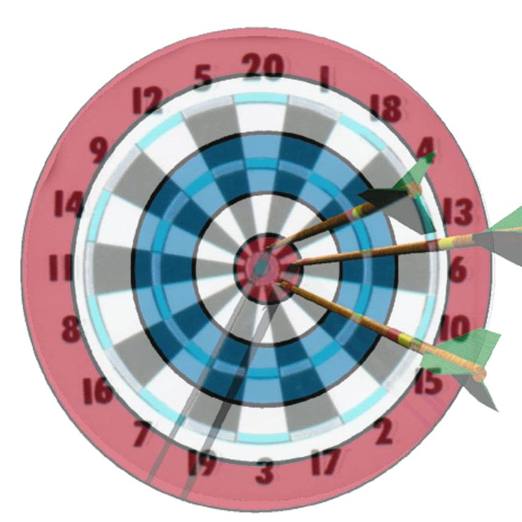
To help us think about this issue, let's think of the city as a bull's eye, where the highest value is closest to the center.
To add some complexity, the City is actually probably a little bit closer to a bullseye with a dart board overlaid to represent "favored quarters" as Leinberger calls them or the singular direction the upper classes fled cities over the last century, along with the various stages of 20th century building patterns in tow.
The spokes on the dart board are important because they act like the geographically responsive network of roads and natural radial pattern of cities. In the country, aka 'burbs, highway and arterials work as collectors because of the low density makes no other form of transportation viable and because the low density allows for people to effectively get away from the undesirable qualities of freeways.
However, if you take those spokes into the cities and attempt to make them respond to the similar transportation pattern of only cars, then the roads have to get bigger as they get to the center of the "dartboard." The spokes of a dartboard do not get wider towards the center, but in cities, and particularly Dallas, they do. If you widen those spokes at the center, you no longer have room for the bull's eye.
The spokes close to the "bull's eye" either have to accommodate other forms of transportation, or get smaller and allow for more people place to accommodate the demand to be there.
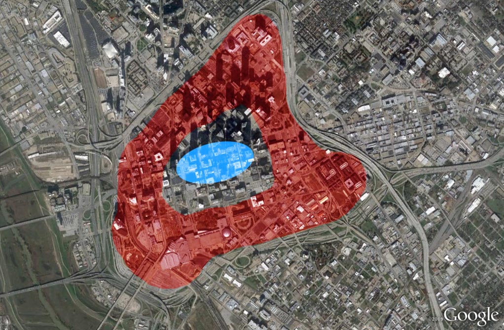
See downtown Dallas, where the majority of downtown bears the brunt of the tourniquet of car only transportation policy, aka serving the countryside, but not the city. The red area absorbs the negative pressure, which is revealed through the numerous surface parking lots, vacant buildings, and otherwise non-performing structures in terms of tax-base. The blue is the beating pulse of a healthy three- to five-block area of downtown.
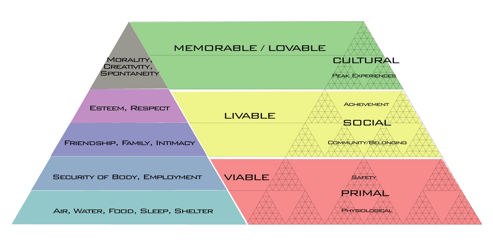
As you get closer to the cores of cities, you have more people, more desire, more demand, the roads should get smaller in a more densely interconnected pattern, not larger. This allows for more supply, more choice, more responsiveness to traffic delays, construction, accidents, etc, a smarter neural network of cities. It is more rigid, more resilient, more attractive without the barriers that highways pose preventing the city from ever achieving that demand, aka what we might call city-actualization, if we are to continue the Maslow Hierarchy of needs metaphor.
Because cars and their infrastructure take up much more space than the various other forms of transportation that DO work and cities AND function better with greater density, we end up undermining the very reason people want to be in downtowns in the first place.
See the example of 34th St in Manhattan, where a recent survey showed that more people move by foot than any other form of transit, followed by mass transit, and least of which cars, which between the vehicle and the infrastructure take up the most space. The City has decided to remove cars altogether from the street in order to accommodate, ghasp, more traffic. Why? Cost (and sanity) of course:
To build New York City to a scale that everyone who rides the morning subway into Manhattan’s central business district could now travel (alone, as most do) by car, for example, would require, as was found by one back-of-the-envelope estimation, an additional 76 Brooklyn Bridges.
While we certainly aren't anywhere near that point yet, this does argue for the shrinking of highways in some locations, the altogether removal in others, and certainly not the widening or adding of additional capacity.
All cities in order to function better economically, socially, and environmentally need to make it more difficult to drive the closer they get to their centers (or multitude of centers for polycentric centies) and easier to get around via various other forms of less consumptive transportation. This means everything at every scale, from more crosswalks, to reduced lanes, to less cloverleaves, less protected left turn lanes, less "flying" right turns, tighter turning radii, etc.
There are solutions appropriate for the country (or State or Province) and their are solutions for the City, but they ARE NOT the same.
"The American love affair with the car...it's an awful lot like Stockholm Syndrome." ~ Me. In the Sixties the philosopher Ivan Illich showed that the amount of energy invested into cars and road infrastructure would be sufficient to cover the distance by foot - and in a considerably more beautiful and peaceful environment.


.jpg)