

A brief note: come to downtown Dallas this evening and join @fortworthology and myself as we do a bit of a pub crawl up and down Main Street Dallas to check out whatever Park(ing) Day parklets are still up and operational. Just took a spin down there as they're setting up.
Now, a point to make about park(ing) day:
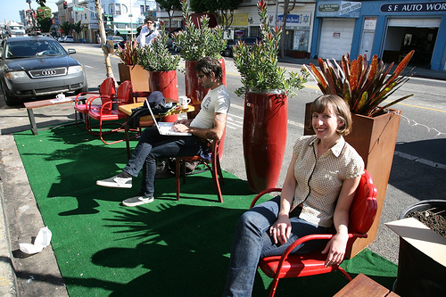
It is taking place today in the Arts District (on Flora), in Deep Ellum (presumably Main Street), and in downtown Dallas (on Main Street). The Park(ing) Day phenomenon was born in San Francisco in 2005 where citizens essentially rented a parking space and rather than park a car they created a park, overfloweth in hipster-driven irony.
And like similar citizen-led initiatives towards improving the urban experience, it is anti-authoritarian by nature. The city is a human invention born out of emotion, needs and wants. It is the platform for accelerating social and economic exchange. It is why city's have and continue to exist as long as civilization has. It is civilization. It is why all things urban are logical and the anti-urban defined by the illogical. The top down, modernist policies of cities favoring the car of people and life and everything cities are intended to provide, have failed. Park(ing) Day, Better Block, etc. are as much performance pieces, messages of protest, as they are improvements.
Graffiti in many ways is about power. And Park(ing) Day is urban graffiti (in a good way). It is citizens taking back their city from the car and the policies favoring the car. Consciously or not, we are all aware something is wrong and that our cities are failing to provide what we need from them, media for social and economic exchange, value in each. The policies favoring the car spread us out, reducing the ability for exchange, lowering the metabolism of the city. Not coincidentally, it makes the city, and us, rather rotund.
As Lewis Mumford wrote: "in dense places, the fast way to move people between destinations is on foot. The slowest is to put them all in motor cars." And if we buy into the fact that density is a product of desirability in a market economy, that is lots of people want to be in a place, then we should want dense places. Density = desirability = places worth caring about. Dense, highly interconnected places are engines of productivity and ideas through that metabolic process. Everything is sped up, including the competition of ideas, producing the best. Therefore, there is significant economic value to what is easily dismissed as "only walkability."
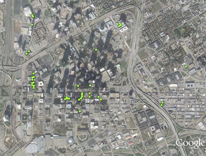
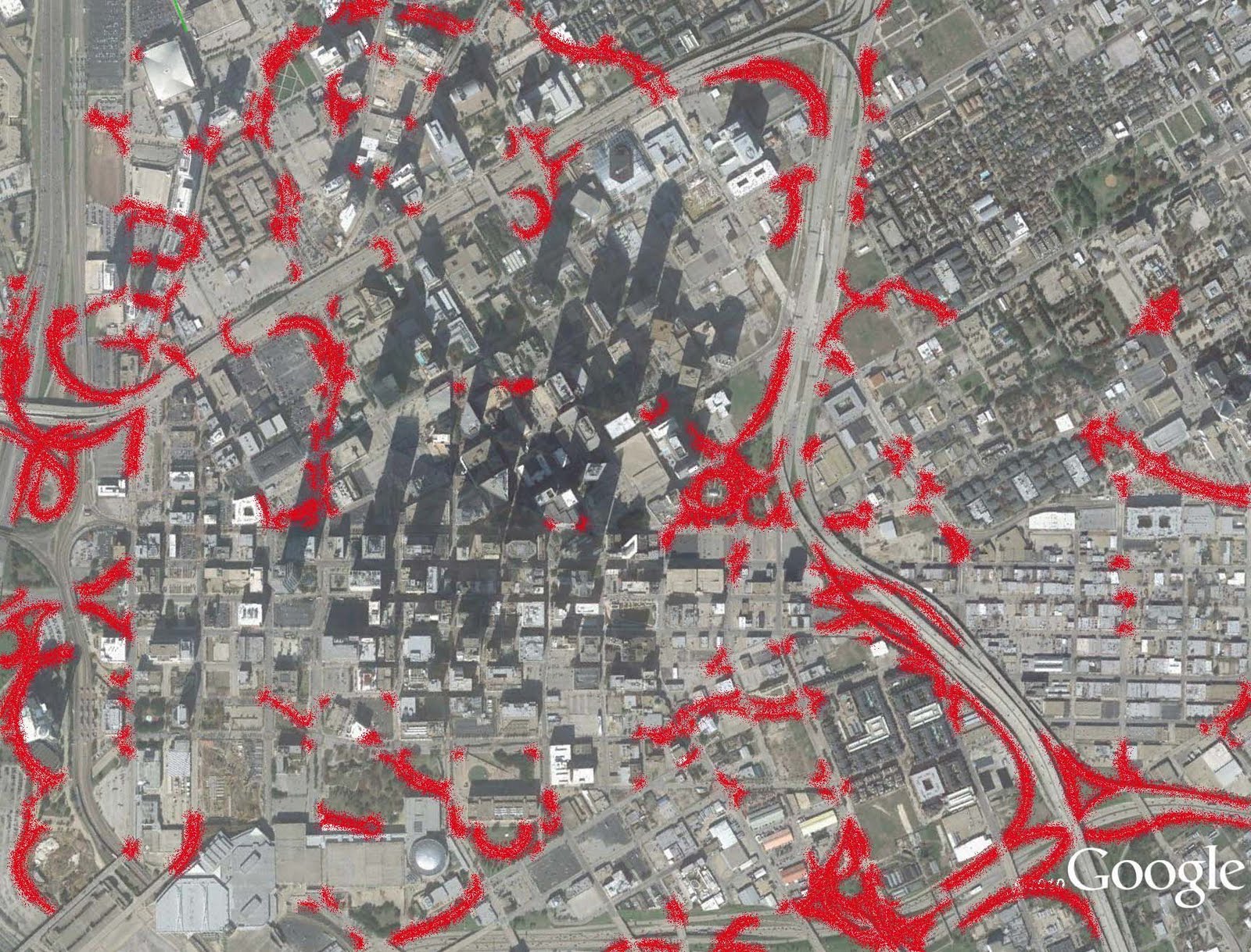
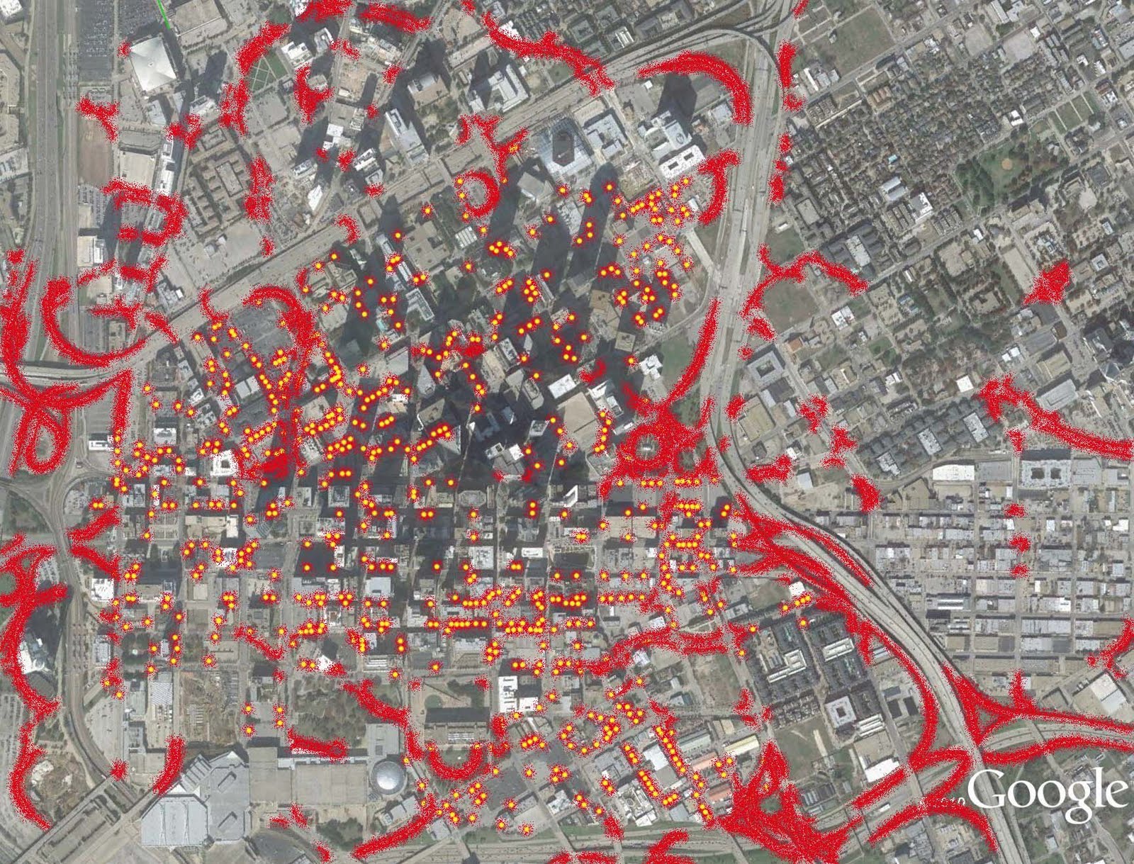
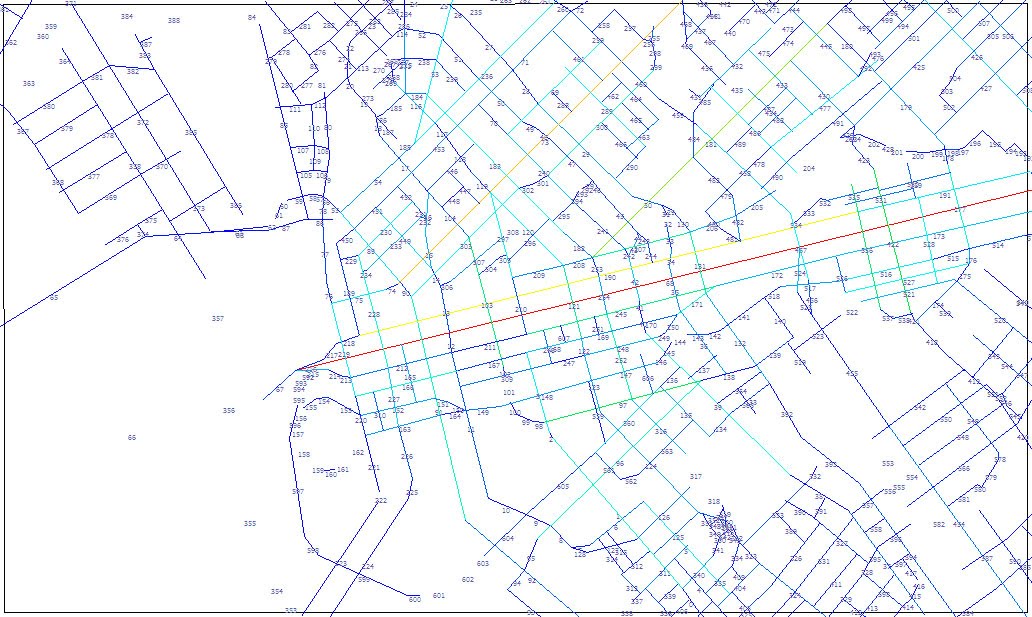
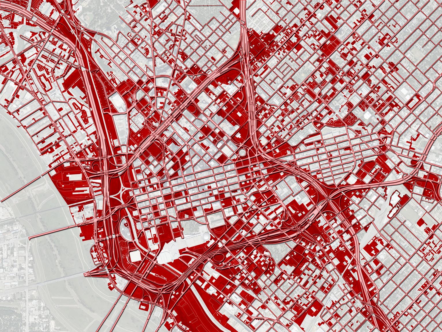
However, when we examine Main Street in Dallas, we have a place that is functional. It is already highly interconnected locally. As the mathematical model using space syntax shows below (red being the most highly interconnected (spatially integrated):
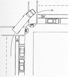
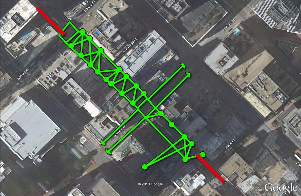
That is from a more macro-level. Below is a map of common pedestrian routes on a block of Main Street. On a micro-level, examining how the specifics of the street actually functions, pedestrians own the street. They cross where they need to. It is what I call, a highly "tethered" street. I'm not saying this is ideal in all locations, but is indicative of safe, pedestrian-friendly locations. Also, desirable places hence the amount of businesses open and thriving on the ground floor interfacing directly with Main Street.
It may not be the prettiest street in the world, trees and shade are rather sparse, but this is not terribly critical to the overall function. Those things are accommodation. Accommodation doesn't make things work or not work. That is why there are so many streets where we mistakenly thought streetscaping would transform the real estate value along it. Integration must come first. So in that way, it is natural for Park(ing) Day to occur on Main Street. It is integrated, driving the demand for more accommodation, which comes in the form of restaurants, residential buildings, office tenants, and in this case, parklets.
But we know it works already. Holding Park(ing) Day on Main Street misses an opportunity. I'm typically all about fostering centers of gravity. And Main Street is that for downtown Dallas. However, by scale, it is little more than a neighborhood main street. There are about 6,000 people living downtown, within walking distance of their neighborhood center, Main Street. San Francisco has 66(!) such walkable clusters, with approximately 6,000 people living within a 1/4-mile of a neighborhood commercial center (of gravity). Desirable.
It is time for downtown and Main Street's success to grow beyond its barriers. And to do so, we have to address those barriers, boxing in the life of Main Street into a short 3-block stretch.
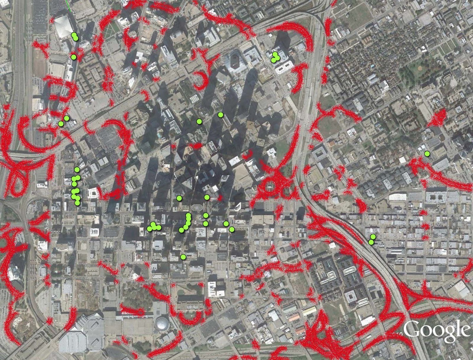
As I just said residential occurs where there is demand. Demand is sparked through spatial integration. See the map below (which is actually a map of ethnicity, but shows density quite effectively):
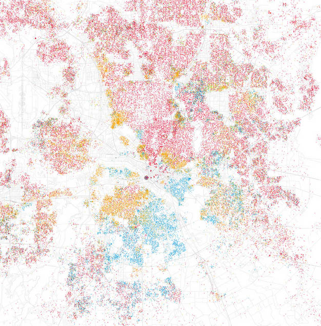
Hopefully, you can click to enlarge this. Sometimes blogger gets a bit unpredictable at times with graphic interface.
If you can click and enlarge take a look at downtown Dallas. It is like a reverse donut, a donut hole, I suppose. All of the dots organize around Main Street with a wasteland around. And this is verified in reality by just walking around. See the space syntax map above. Where integration is high, demand is high. Where demand is high, value is high because people want to be there, and are then accommodated via habitable real estate.
Or see this map showing parking and underdeveloped properties:
Car-centric road design and geometries undermine spatial integration, walkability, and safety. These policies reduce value, and the only accommodational demand is for space for cars, parking. Park(ing) Day is a baby step towards reversing this. Except hosting it on Main Street means it is only a one-time event. It is not profound nor transformational.
Meanwhile, running parallel to Main Street are Elm and Commerce Streets, which apparently are untouchable because some arbitrary traffic formula says they must be wide. Ironically, if we're trying to create density in downtown the stance becomes "more people = more cars, must have more road capacity" when in reality more people = less need for cars because everything is closer together. This is the illogic of modernist planning, why it is failing cities, and why viscerally, we feel we must do something about it through demonstration projects like Park(ing) Day.
Furthermore, and not coincidentally, if the road network in downtown was not primarily of one-ways, T-intersections, dead ends, overly large blocks, etc., there would be more choice of route thereby creating 1) a more navigable system, 2) a smarter system that empowers users to use their brain and make the appropriate decisions of route and mode, and 3) creates more capacity in the overall system because of that increased choice. A smarter, more flexible system.
Now take a look at Elm Street, right next door to Main:

Elm and Commerce are both overly wide one-way roads that box in the success of Main Street. The built space along them matches their spatial integration, forlorn. The width and the speed allowed for cars because of that width "untethers" the road reducing the spatial integration, the connectivity via the ability to cross and how desirable it is to be next to cars (and DART buses) zipping by at 50 mph. Consciously and subconsciously our brain is telling us, "that thing could kill me, get away from this place."
Kudos to those cities that have since embraced these ideas and are making ground-up initiatives part of public policy, but if we wanted to make a difference long-term for the city and particularly downtown's revitalization, we would hold these events on Elm and/or Commerce. How about a loop even?
I understand fully that Main Street is the ceremonial street. After all it is "Main Street." Except it is already spatially integrated, a positive experience. Let's give it a numerical value of +1. The added accommodation (parklets) transforms it into a +2, a prettying it up so to speak.
+2 - integrated, accommodated
+1 - integrated
-1 - accommodated not integrated (ie prettying up low-functioning roads)
-2 - neither accommodated nor integrated
Elm is a negative experience and this bares out in the adjacent real estate, which retreats from it in horror, seeking safer more hospitable locales. At best it is a -1 street by the above semi-arbitrary, semi-rhetorical criteria. It received some streetscaping and predictably that accomplished little. All cost, no return. This is what happens when you don't change the functionality of the street. There is more value to be gained and less buck to be spent taking -1 and/or -2 streets into +1 streets rather than +1 streets into +2 streets.
I suspect there will be the most parklets in the downtown Main Street. Integration begets accommodation. Each parklet is a form of accommodation, space for people. Main Street in downtown is the most integrated of the three locations and that is precisely why this will make for a fun event, because there are already restaurants and bars to interface directly with it. But that is all it will be, a one-day event. That is why I've taken to calling these (perhaps too derisively) puppet shows.
They are indeed fun events (although, now grown up puppet shows are only one-step below clowns on the creepiness scale). However, if we want to actually accelerate the revitalization of downtown, we would use these opportunities, the increased interest in citizen participation in urban development, to host Park(ing) Day and things like it on the bad streets. We would demonstrate that narrowing the bad streets, those that constrict life into tiny little pockets around the city, is in fact, not CARMAGEDDON, but quite the opposite really.
Urbanism is about the amplification via interconnected places facilitating synergy through interdependence. These roads are dividers moreso than connectors. Rather than extinguish life, it would might allow it to flourish once again. If the city continues to make things like Park(ing) Day official public policy we might as well kill 2 birds with one stone and do what cities are supposed to do, facilitate social and economic exchange through improved spatial integration.