Showing posts with label Downtown. Show all posts

Monday, April 2, 2012

Of Glass Boxes and Glass Slippers

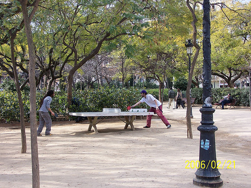
One of the tragic things working in Dallas is the amount of people and effort trying to make things work, make the city more urban, ultimately giving it a longer shelf life, is that there are many smart people trying to make little changes within a fundamentally broken ship. Sardonically, we might call this rearranging deck chairs on the Titanic. However, we tide ourselves over with the comforting thought that a million (or only a dozen) small actions can lead to a tidal wave of change. The big changes to the underlying DNA of a place are just too difficult, too politically charged to even bother with, instead we'll just set the table, the linen, the silver, and the china on this one little dining table. So what the boat is headed for the iceberg of inevitability?

Perhaps neatly and accidentally summing this up is the news from the weekend that the City of Dallas, and in particular the parks department, is going to update the downtown parks masterplan. Buried within the subtext is a brief mention of two high-rises that are coming down to make room for new parks? New something. Probably not buildings. And if they are, they likely won't make money. Such is the state of downtown Dallas. Things happen by charity and subsidy because the transportation framework is stacked against downtown.
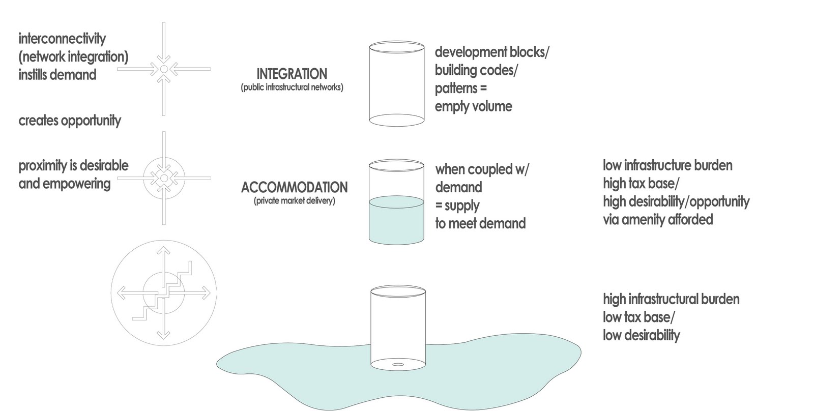
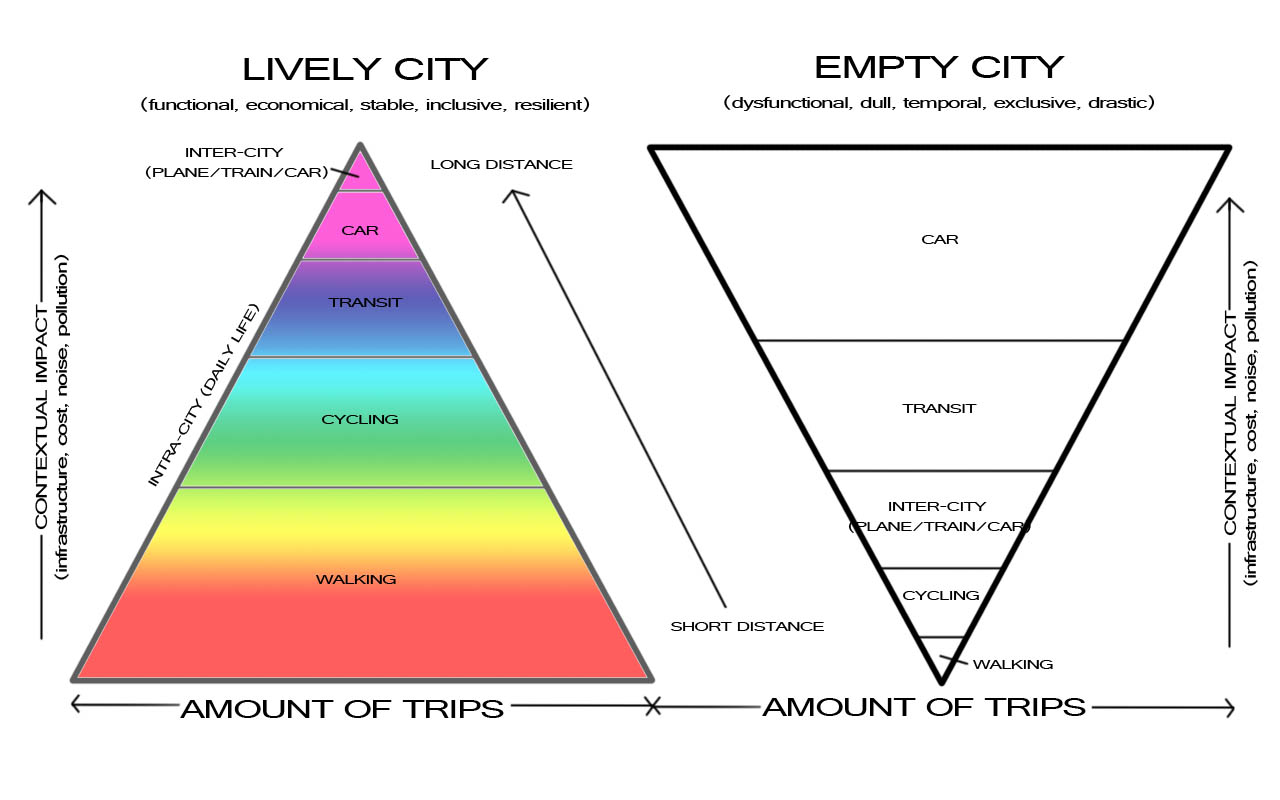
The glass is empty, so throw out the glass. Sure, the numbers don't work to fill that glass, but that isn't necessarily the fault of the glass, but the infrastructural network creating the hole in it instead.

I've been saying this for a while now, but the highest and best use for downtown land is nothing. Sad to say and sorry to challenge your world view, but this is inevitable within the broken system. Thus, within that system, we rationally think that nothing or a park is better than a building. That building is empty, so take it down, of course! Demand is too low to make anything work within that building. So instead of instilling demand, we reduce supply.

I forwarded this story to someone over the weekend who responded derisively, "let's just tear down all the buildings and make a wildlife safari." Or maybe move the zoo and let jungle cats roam the streets. Highest and best use: parks and parking. Perhaps it is time to admit we're doing it wrong and systemic reform is necessary to how we think about our city, cities in general, and the underlying processes behind urbanization (or in this case, anti-urbanization).

-------------

Along these lines, Robert Wilonsky, formerly of the Observer and now mainstream at the DMN -- but still working 24/7, sent along the news that the city is seeking an operator for their first 'glass box' retail space. The glass box semi-'popup' retail space is something born of the downtown 360 plan. It creates retail space in places that currently lack it. In essence, it is giving an interface to blank walls. However, there is a catch. There must be demand before supply.

It's not a terrible idea. In fact, it is a good one. But there is a slippery slope. Again. And that is if they are used willy nilly, then they are supply side urbanism and thus doomed to fail. For the city to erect these glass box buildings is good in a few ways: (1) it eliminates some startup costs (and barriers) for a small, local business to locate in downtown Dallas. (2) It provides an interface for a buildings currently lacking one, ie a front door engaging the public realm where currently there is none, a blank wall.

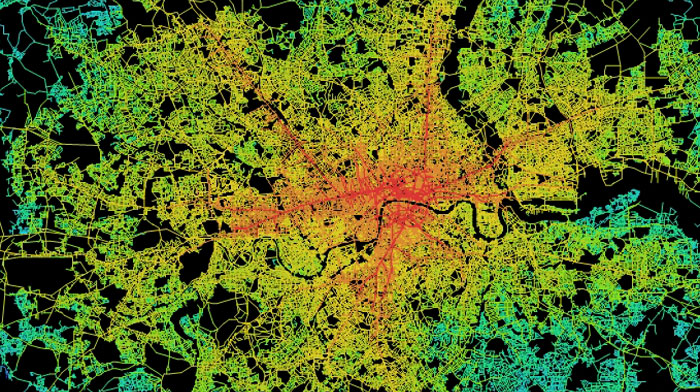
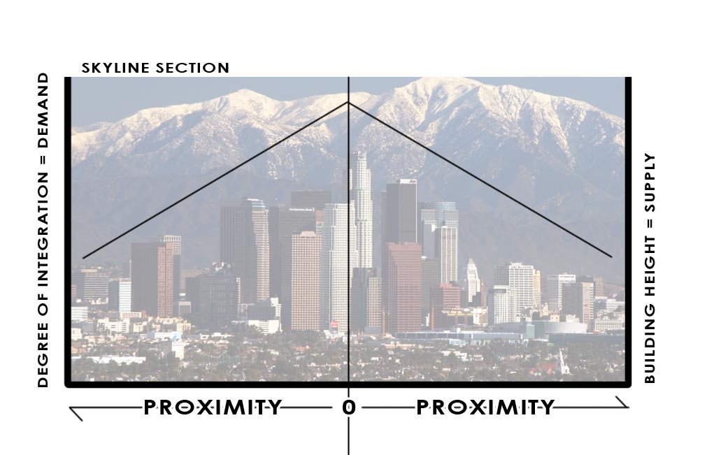
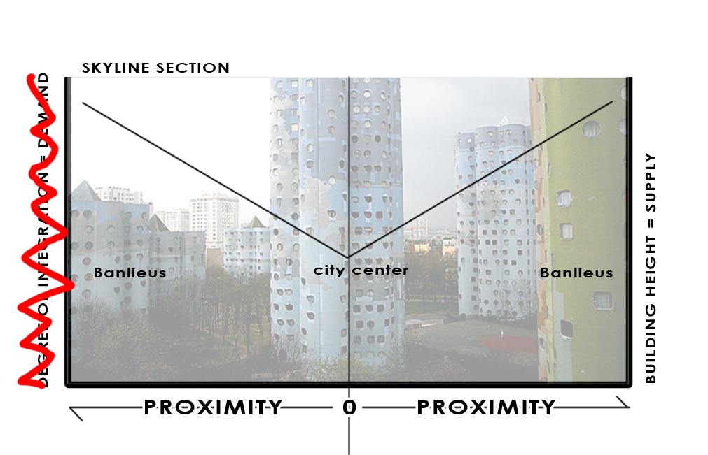
It is potentially bad if these are established in places where they won't succeed, in areas of low spatial integration. Spatial integration = demand = greater chance of success, the quick wins the city and the downtown 360 plan are looking for.

So, if we're looking for a quick win for the idea of the "glass box" in micro and downtown success in macro, you'd think we'd locate the first glass box in the location where it has the highest chance of success. Since there are several potential locations for the idea of laminated retail space on a current building facade, we have to pick the place that has the highest spatial integration value. Unfortunately, that isn't Browder Plaza. Yes, it needs it, but making this phase one is the right place at the wrong time. Or wrong place at the right time. Both suffice.


BrowderStreetPlaza.JPG
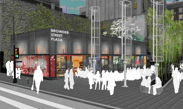
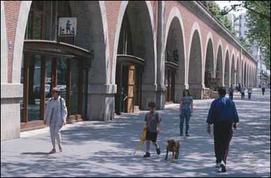
I too love theoretical people in renderings. But where do they keep their wallets? Is this how we visualize tourists? As apparitions, floating amongst us, the real and true Downtowners?

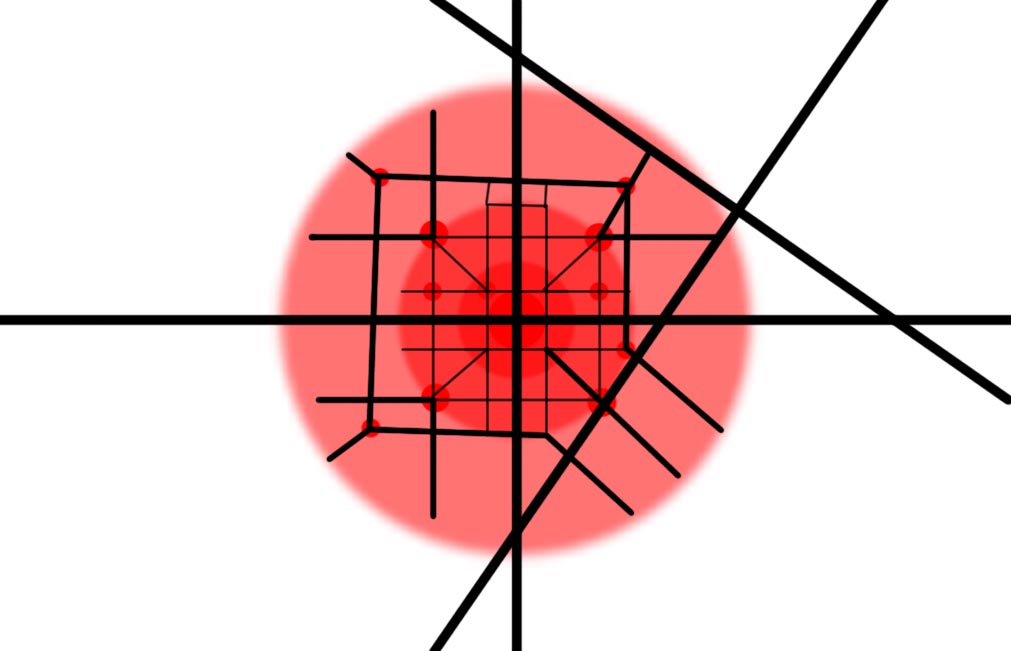
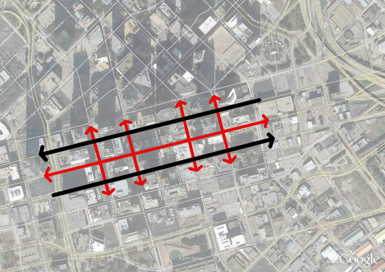
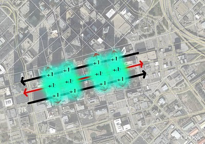
These people have to come from somewhere and that somewhere is through spatial integration. As I wrote about the McKinney Avenue Trolley last week, through movement is not nearly as important as cross movement because the people that cross the street are from the neighborhood, the street serves the neighborhood, and those are the people that populate the sidewalk and thus patronize businesses that interface with the street. Furthermore, these are return customers who keep businesses afloat.

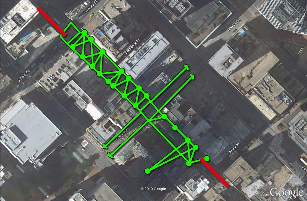
I don't know all the decisions behind establishing the first glass box on Browder Street, a pedestrian plaza closed to car traffic, linking Elm and Jackson Streets. It very well could be that the city is trying to make retail work on Elm Street since it hasn't on its own. But that is part of the problem. It works on Main Street for a reason. There is a higher degree of integration on Main Street. Where Main and Akard meet at Pegasus Plaza is the crossroads of downtown. It is the single point of highest integration in all of downtown, its "Main & Main" corner.

There just so happens to be a perfect place on Pegasus Plaza as well:


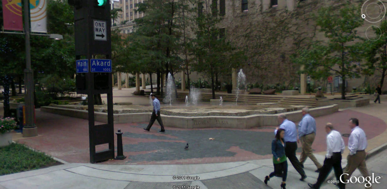
As you can see above, the back of the Magnolia hotel fronts on Pegasus Plaza. Currently, this is a doggie dumping ground. I believe this is even a location picked out by the downtown 360 plan for retail lamination. Placing phase 1 here would build on the success already of Main Street rather than trying to expand that success beyond its natural boundaries. Those boundaries are Elm, Commerce, Field, and Ervay currently.

I'm the first to say we have to build outwards upon Main's success, but that can't be done without addressing Elm and Commerce's natural barrier effect. Much like rivers can't be crossed without fords or bridges, a river of cars is also a barrier to crossing, thus decreasing spatial integration. Meaning less pedestrians, less value.

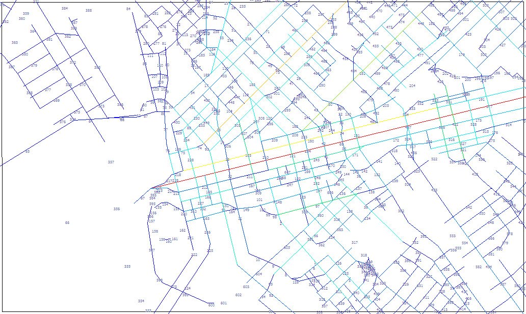
City has added brick to the sidewalks on Commerce, but has spent nor done anything to actually change the functionality, the integration, of the street. The street is not narrowed, calmed, nor slowed. A center of gravity is not made. It is simply an aesthetic treatment, ie the least important thing you can do if you're really, really trying to catalyze change. Along those lines with the RFQ, the city is spending $500K to pretty up the concrete heavy Browder Plaza. Again, as with all superficial treatments, without first upping the degree of integration, cost significantly outweighs returns.

Now it could be that Commerce is ready for something there, but it is a gamble. Not the sure thing, nor quick win it is being espoused as. This may be a timing issue in conjunction with Forest City delivering more units further down Commerce, however the gravitational pull will remain Main Street as long as Elm and Commerce exist as they do, as escape routes. Places to save time rather than spend time.

The second problem here, is that there is a good chance this is the city picking and choosing winners. I'm no fundamentalist libertarian, but it is rarely a good thing. The public agency is better off focusing on instilling demand through the establishment of a transportation network that is about clustering. That is about demand, rather than about moving people out. Rather than instilling demand, the city is adding supply of new restaurants by funding the startup costs in essence within an area that is likely maxed out on restaurant/entertainment/retail space.

I have no data, just experience living in downtown, but I get the sense that the integration increment DART added to downtown has maxed out. Downtown is what it is now, rather than what it was nearly dead in 2000, because of DART. If we are indeed maxed out, new retail space cannibalizes from existing retail space. From living and being in downtown every day, and experiencing the evolution, it certainly seems like what is happening. One new place opens, another closes.

All of these issues, point towards an economic development program that is better aligned with urban design, and vice versa. I get the sense that they are aligned, just misguided currently. Integration begets accommodation (and decoration). Merely adding accommodation (and decoration) via a variety of incentive packages is spending to get minor successes. The solution is right in many ways, but the superficiality, the supply-sidedness of it, undermines the effort towards quick wins.

Alas, the glass slipper is still just a pumpkin.

Post Script:

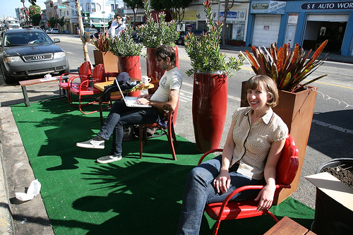
Big Jon Daniel asked on twitter if this is a shot by the city "across the bow of food trucks." I don't think that is it at all. In fact, one of the food truck operators would probably be an ideal operator for the first (or any subsequent) glass boxes. Food trucks started because of the reduced startup costs in conjunction with the poor locational efficiency of the majority of the city. Simply put, entrepreneurs couldn't locate in the appropriate spots due to a variety of cost barriers, both real estate and operational.

Speaking for the food trucks, I would expect some would like to grow and expand their business. Many would like to grow up and have ambitions of a permanent establishment. If one of the food trucks moved in to the glass box, that would allow the laminated retail space to operate as a supply depot for the truck. At night, it could even park adjacent along the street and create a little cluster effect between the restaurant and the truck (particularly if the two filled separate culinary niches). Of course, that would mean parking on Commerce Street, altering its traffic flow patterns (God forbid!) and thus, another good idea dies a premature death.


Wednesday, January 25, 2012

Why Are Skylines Roughly Conical?

I want to take a graphic look at some concepts I've been developing lately, in conjunction of course with the work it builds upon, including the Bartlett School at the University College of London and their work on mathematical models of spatial integration as well as the Andres and Douglas Duany codeveloped concept of the transect.

Spatial integration began as a scientific examination searching for objective realities to urbanism. Why were cities and their patterns so similar? Where and when have we begun to go wrong? And is the aesthetic, subjective driven world of Modernist architecture partially to blame?

Completely independent of this work, the Duany brothers saw similarities in the gradient of intensification of cities as you got closer to the core with various ecologies, particularly coastal regions:


This, became this:


Both relied, perhaps intuitively on the concept of centrality, which has its origins in the study of social networks. Since cities are the physical platform for social and economic exchange, empowering the links between them, network studies had direct relevance. Cities are networks.
But the Transect never really digs into why what was where. Sure there is a dense node at the center, with an decreasing gradient the further you get away from it. But what created centers in the first place? That is where space syntax began examining infrastructural networks. Professor Bill Hillier and his pupils/colleagues found a correlation between social network analysis and infrastructural networks. That is, social hubs have the most connections. The highest degree of integration. Likewise, this parallels with the internet. The highest trafficked sites are hubs that all others link to. Think Google. From there exists a hierarchy from most to least.

Likewise, cities have a similar hierarchy. The most connected places, have the highest degree of integration, which in turn means the highest degree of opportunity. Where there exists the greatest demand, to which the market responds with supply. Building space. Where demand is greater than supply exists the most opportunity for developers. Where integration is highest is the most opportunity for every citizen to meet their needs for social and economic exchange.

This concept exists locally, within one city, as well as globally, amongst all cities. New York, London, Tokyo, Paris, etc., are global cities because they are the most connected, both locally and globally. Within a single city, you also have a hierarchy of centers. All cities are polycentric once they get above the scale of the tiniest of hamlets. This is what sprawl apologist hacks like Joel Kotkin fail to understand. When they talk of polycentric, sprawl-based cities as polycentric cities of the future, they fail to see that New York is also polycentric. Those centers just blur together rather seamlessly, except where geographic barriers (water bodies) or physical barriers (such as highways) divide and isolate them.

Space Syntax map of London:

What they found was that there is a correlation between traffic and value. Just like with any network, particularly the web. The most trafficked sites have the most value. Remember that traffic doesn't mean cars, but people. This is a direct relationship in what I call logical cities. High pedestrian areas have far more people moving past, and capable of interacting with you (economically or socially) in these high traffic areas than does car-based traffic, which has to turn, wait for lights, find parking, etc., all of which accounts for increasing degrees of disconnection, dislocation, and inflexibility.

In the logical city, such as the London-based map above, there is another chicken/egg based component to it as with all complex, interconnected systems. The infrastructure funnels traffic to specific places and specific places also "bend" the infrastructure to them. This is why I call them centers of gravity, what many planner types call "nodes". They literally shape the city around them. Increasing their level of interconnectivity, raising demand, and eventually via opportunity, supply.

Because of the chicken/egg scenario, this also means that infrastructure can create places out of thin air, such as when two railroads meet in the midwest. The traffic intersection becomes an opportunity. And many cities are here today because of such a phenomenon. I'll look at that a little more later.

But first, here are several skylines:
While this is Dallas and the exercise is admittedly abstract, I want to show why downtowns have the biggest buildings. And why severing the interconnectivity to them, is why many of Dallas's buildings in downtown are quite empty, for example. As I have written before, Dallas experienced a building boom (high-rises) at the exact same time that the city, state, and federal level were gorging on highway building. Supply was being added while demand was being undercut, shipped out towards the suburbs.

Those polycenters, instead of being closely interconnected, became Las Colinas and the various highway adjacent corporate office parks around the metroplex. That they were newer or the space is better and they are "grade A" office is irrelevant. The newer development would be in and around more walkable, more highly integrated and interconnected places (more authentic places). They would also prove to be more resilient. I expect, unless they drastically reposition themselves, many of these office parks will fade into dust. With new light rail (another degree of interconnection) and residential, Las Colinas is already doing that.

Compare our growth to say, L'Eixample neighborhoods in Barcelona and Valencia. These were rapidly expanding areas, literally doubling city size, but they did so aggregately. These are both now considered the "old money" areas of those particular cities, and very much still central city as growth then enveloped them.


The dynamic changes a bit for cities like Paris or Washington, D.C. Both cities with extremely high levels of integration, locally and globally. Remember, that local integration is the foundation from which density and resilience lie upon. The most connections can be made locally in dense, walkable environments.
Because the level of integration is so, demand is extremely high to be in the center of Paris (or D.C.). But height restrictions limit the amount of supply of usable building space, making prices skyrocket. The center of Paris is amazing. Who doesn't love it? But it also leads to this condition where opportunity then shifts outward, toward the Banlieus, or suburbs:
The supply is much greater than the demand, which is to be actually in Paris where opportunity is high. But it the market can't meet the demand, so it spills outward. Too much supply, with too low levels of integration. There isn't a natural, organic match. This is made even worse with the design of the "towers in the park" housing for the poor. Whether they were built for the poor or not, eventually they were doomed to devolve because of supply being much greater than the demand. These types of Corbusien buildings are physically isolating, cul-de-sacs in the sky. In effect, the supply is borrowed from the areas with higher integration, higher value. Not coincidentally, these are the areas where Paris experiences the most civil unrest, in homogenous areas of poverty exemplified by socio-economic isolation. Isolation. As in not integrated.

However, this is not to say whether Paris or DC's restriction on building height is wrong. That is a political debate. In my estimation, these cities heights or lackthereof is precisely what makes them so special. 1) The building heights remain humane, lower to the street level, and more interactive. And perhaps more importantly, 2) the demand pressure exerted upon a limited supply ensures that the limited space will always, ALWAYS be maximized. And buildings will be preserved rather than destroyed.

The real issue is improving the connectivity, integration, and walkability within and to the suburbs. Here is where I shift in language from banlieus to suburbs because the need is universal. American suburbs may not have many, if any, high-rises, but supply is currently way above demand, as defined by spatial integration values. Values are plummeting across the country, not only because of the evaporation of liquidity (real or imagined), but also a general market realization and price correction towards this supply/demand imbalance.

There is a movement afoot to "retrofit suburbs." While there is certainly opportunity to do this, and a necessity in many cases. I'm afraid that while some areas will be fine, some will need salvaging, while others are fairly doomed. We simply won't have the capability of retrofitting ALL of them. And by retrofitting, I mean increasing their local connectivity/integration quotient to instill, increase the demand to catalyze the new infill that the retrofitters propose. There will be extreme levels of competition and upheaval, I expect, in American suburbs.

As for city growth:

As I mentioned earlier, it all starts with an intersection. This could be anything:

Two railroads crossing
Two ancient trade routes
Fertile soil and a deep water port

The connection globally has to be strong enough to maintain the raison d'etre. The local connections, like walkability, ensure that the place is efficient and livable. And that people like living there as opposed to the competitors. It is also important to note that no cities current place within the hierarchy is the place it will reside in 10-, 20-, 50-, or 1000-years. Such is the competition amongst cities. And such is the need to maximize local and global connectivity, as well as the raison d'etre for that city, whether it be energy production, idea production, or a socially vibrant place. Whatever it is, it better be timeless. See: Detroit, autos. West Texas, exhausted oil wells. Heterogeny ensures timelessness. Or something approaching it.

Here is the intersection. Imagine it is any of the aforementioned. The red implies the neighborhood development.


If the raison d'etre is strong enough, its opportunity level persists. It attracts more people. The city expands, aggregates:


Eventually, maybe it grows to the point where it needs more global connections. And as technology advances, the infrastructure is needed for those global connections, such as an airport and an interstate. However, all global movement is destructive to fragile local interconnections. Highways and airports can have negative effects upon overall interconnectivity despite increasing global connectivity. Local connectivity drops, therefore demand drops, therefore desirability and opportunity drop and eventually people will leave that city. That is why these global infrastructural networks must be treated very carefully, connecting with cities tangentially.

Vancouver didn't allow freeways into their city. Paris is removing all of them inside the peripherique. They're connected to their airports via subway. Subways are built because at-grade and above grade tracks are disconnective. Below grade is supremely expensive, but as all cities who have them have found, worth the high initial cost to preserve the fabric above.


And within those overall connections, smaller nodes or centers of gravity will emerge at the various convergence points. That is, only in the logical city. In the illogical city, where connections are disruptive and diminish overall connectivity and the ability of its citizens to meet their social and economic needs for exchange, a tension is created. The tension is two countervailing forces. That towards traffic, ie traffic = value. And the opposite force is the repulsive nature of those global connections, ie highways and airports.


You may have to click on the below image to expand it. It's one I've been working on to explain this concept. At the top left we have attractive nature of convergence. People create infrastructure to create opportunities for social and economic exchange, meeting points, trading places, markets. When you disrupt that network, you shift the magnetism so to speak, like putting two like poles of magnets next two each other.


When you look to the right diagram, the glass is supply of building form. The demand is liquid. When you interrupt local connectivity and overall integration (often for the sake of global connectivity), you are essentially creating a hole in the glass. All of the demand spills outward. You get sprawl and an empty glass. Like downtown Dallas highrises.

Friday, September 16, 2011

Park(ing) Day, Downtown Dallas & Happy Hour


A brief note: come to downtown Dallas this evening and join @fortworthology and myself as we do a bit of a pub crawl up and down Main Street Dallas to check out whatever Park(ing) Day parklets are still up and operational. Just took a spin down there as they're setting up.

Now, a point to make about park(ing) day:

It is taking place today in the Arts District (on Flora), in Deep Ellum (presumably Main Street), and in downtown Dallas (on Main Street). The Park(ing) Day phenomenon was born in San Francisco in 2005 where citizens essentially rented a parking space and rather than park a car they created a park, overfloweth in hipster-driven irony.

And like similar citizen-led initiatives towards improving the urban experience, it is anti-authoritarian by nature. The city is a human invention born out of emotion, needs and wants. It is the platform for accelerating social and economic exchange. It is why city's have and continue to exist as long as civilization has. It is civilization. It is why all things urban are logical and the anti-urban defined by the illogical. The top down, modernist policies of cities favoring the car of people and life and everything cities are intended to provide, have failed. Park(ing) Day, Better Block, etc. are as much performance pieces, messages of protest, as they are improvements.

Graffiti in many ways is about power. And Park(ing) Day is urban graffiti (in a good way). It is citizens taking back their city from the car and the policies favoring the car. Consciously or not, we are all aware something is wrong and that our cities are failing to provide what we need from them, media for social and economic exchange, value in each. The policies favoring the car spread us out, reducing the ability for exchange, lowering the metabolism of the city. Not coincidentally, it makes the city, and us, rather rotund.

As Lewis Mumford wrote: "in dense places, the fast way to move people between destinations is on foot. The slowest is to put them all in motor cars." And if we buy into the fact that density is a product of desirability in a market economy, that is lots of people want to be in a place, then we should want dense places. Density = desirability = places worth caring about. Dense, highly interconnected places are engines of productivity and ideas through that metabolic process. Everything is sped up, including the competition of ideas, producing the best. Therefore, there is significant economic value to what is easily dismissed as "only walkability."

However, when we examine Main Street in Dallas, we have a place that is functional. It is already highly interconnected locally. As the mathematical model using space syntax shows below (red being the most highly interconnected (spatially integrated):


That is from a more macro-level. Below is a map of common pedestrian routes on a block of Main Street. On a micro-level, examining how the specifics of the street actually functions, pedestrians own the street. They cross where they need to. It is what I call, a highly "tethered" street. I'm not saying this is ideal in all locations, but is indicative of safe, pedestrian-friendly locations. Also, desirable places hence the amount of businesses open and thriving on the ground floor interfacing directly with Main Street.

It may not be the prettiest street in the world, trees and shade are rather sparse, but this is not terribly critical to the overall function. Those things are accommodation. Accommodation doesn't make things work or not work. That is why there are so many streets where we mistakenly thought streetscaping would transform the real estate value along it. Integration must come first. So in that way, it is natural for Park(ing) Day to occur on Main Street. It is integrated, driving the demand for more accommodation, which comes in the form of restaurants, residential buildings, office tenants, and in this case, parklets.

But we know it works already. Holding Park(ing) Day on Main Street misses an opportunity. I'm typically all about fostering centers of gravity. And Main Street is that for downtown Dallas. However, by scale, it is little more than a neighborhood main street. There are about 6,000 people living downtown, within walking distance of their neighborhood center, Main Street. San Francisco has 66(!) such walkable clusters, with approximately 6,000 people living within a 1/4-mile of a neighborhood commercial center (of gravity). Desirable.

It is time for downtown and Main Street's success to grow beyond its barriers. And to do so, we have to address those barriers, boxing in the life of Main Street into a short 3-block stretch.

As I just said residential occurs where there is demand. Demand is sparked through spatial integration. See the map below (which is actually a map of ethnicity, but shows density quite effectively):

Hopefully, you can click to enlarge this. Sometimes blogger gets a bit unpredictable at times with graphic interface.

If you can click and enlarge take a look at downtown Dallas. It is like a reverse donut, a donut hole, I suppose. All of the dots organize around Main Street with a wasteland around. And this is verified in reality by just walking around. See the space syntax map above. Where integration is high, demand is high. Where demand is high, value is high because people want to be there, and are then accommodated via habitable real estate.

Or see this map showing parking and underdeveloped properties:
Car-centric road design and geometries undermine spatial integration, walkability, and safety. These policies reduce value, and the only accommodational demand is for space for cars, parking. Park(ing) Day is a baby step towards reversing this. Except hosting it on Main Street means it is only a one-time event. It is not profound nor transformational.

Meanwhile, running parallel to Main Street are Elm and Commerce Streets, which apparently are untouchable because some arbitrary traffic formula says they must be wide. Ironically, if we're trying to create density in downtown the stance becomes "more people = more cars, must have more road capacity" when in reality more people = less need for cars because everything is closer together. This is the illogic of modernist planning, why it is failing cities, and why viscerally, we feel we must do something about it through demonstration projects like Park(ing) Day.

Furthermore, and not coincidentally, if the road network in downtown was not primarily of one-ways, T-intersections, dead ends, overly large blocks, etc., there would be more choice of route thereby creating 1) a more navigable system, 2) a smarter system that empowers users to use their brain and make the appropriate decisions of route and mode, and 3) creates more capacity in the overall system because of that increased choice. A smarter, more flexible system.

Now take a look at Elm Street, right next door to Main:

Elm and Commerce are both overly wide one-way roads that box in the success of Main Street. The built space along them matches their spatial integration, forlorn. The width and the speed allowed for cars because of that width "untethers" the road reducing the spatial integration, the connectivity via the ability to cross and how desirable it is to be next to cars (and DART buses) zipping by at 50 mph. Consciously and subconsciously our brain is telling us, "that thing could kill me, get away from this place."

Kudos to those cities that have since embraced these ideas and are making ground-up initiatives part of public policy, but if we wanted to make a difference long-term for the city and particularly downtown's revitalization, we would hold these events on Elm and/or Commerce. How about a loop even?

I understand fully that Main Street is the ceremonial street. After all it is "Main Street." Except it is already spatially integrated, a positive experience. Let's give it a numerical value of +1. The added accommodation (parklets) transforms it into a +2, a prettying it up so to speak.

+2 - integrated, accommodated
+1 - integrated
-1 - accommodated not integrated (ie prettying up low-functioning roads)
-2 - neither accommodated nor integrated

Elm is a negative experience and this bares out in the adjacent real estate, which retreats from it in horror, seeking safer more hospitable locales. At best it is a -1 street by the above semi-arbitrary, semi-rhetorical criteria. It received some streetscaping and predictably that accomplished little. All cost, no return. This is what happens when you don't change the functionality of the street. There is more value to be gained and less buck to be spent taking -1 and/or -2 streets into +1 streets rather than +1 streets into +2 streets.

I suspect there will be the most parklets in the downtown Main Street. Integration begets accommodation. Each parklet is a form of accommodation, space for people. Main Street in downtown is the most integrated of the three locations and that is precisely why this will make for a fun event, because there are already restaurants and bars to interface directly with it. But that is all it will be, a one-day event. That is why I've taken to calling these (perhaps too derisively) puppet shows.

They are indeed fun events (although, now grown up puppet shows are only one-step below clowns on the creepiness scale). However, if we want to actually accelerate the revitalization of downtown, we would use these opportunities, the increased interest in citizen participation in urban development, to host Park(ing) Day and things like it on the bad streets. We would demonstrate that narrowing the bad streets, those that constrict life into tiny little pockets around the city, is in fact, not CARMAGEDDON, but quite the opposite really.

Urbanism is about the amplification via interconnected places facilitating synergy through interdependence. These roads are dividers moreso than connectors. Rather than extinguish life, it would might allow it to flourish once again. If the city continues to make things like Park(ing) Day official public policy we might as well kill 2 birds with one stone and do what cities are supposed to do, facilitate social and economic exchange through improved spatial integration.


Friday, August 5, 2011

Downtown and Doggie Doo Doo, It Never Ends

Besides the scourge of highways on the intricate, fragile ecosystem of cities as a collection of highly interconnected neighborhood units, I feel that I've written nearly as extensively on dog shit. See: here and here. The lesson from those, as always, Virginia Postrel has no idea what she's talking about.

This morning on an otherwise uneventful dog walk, I was interrupted by a gentleman attempting to grab my attention in that familiar North Dallas dialect, by honking his horn. I typically and intentionally ignore this form of communication because I have eyes, ears, am an adult, and speak English and at least enough Spanish if that happens to be the honker's native tongue.

Honk once, honk twice, honk thrice, and again a fourth time. Okay, what the F is your problem? Of course, without the attitude I looked up to see if this person was honking at me or any of the other people on the street. How is one to know? Isn't the responsibility of directing attention on the honker?

A deeply tinted passenger front window of a black Denali slowly rolls down in that perfectly uniform automatic way, and a white collared man asks, rather politely I should add, "please don't walk your dog there."

"No problem," I replied and moved on down the road. A couple of things should be noted. First, I'm one of the good ones. First, I carry multiple baggies at all times and loathe dog owners who do not pick up their pets mess with extreme prejudice. I even degrade the environment (!1!!11!1) by asking for plastic bags at the grocery so I can always have extras in the pantry to supplement the roll-out kind purchased at pet-smart.

Second, there are no signs asking not to take dogs there and downtown dog owners use this spot hourly if not almost consecutively throughout the entire day. I've seen them. I also see the dog poop (I hope - you sometimes never know in downtown Dallas) left by negligent owners and must carefully avoid stepping in it.

Third, downtown's population is not huge, roughly 5,500 and change, or about the size of a single, mature neighborhood. Substantial enough that in a heavily concreted place as downtown, two things are assured, 1) people will have pets no matter what and 2) all areas of grass will be used for doggie relief and are valued highly as such. Supply low, demand high.

Now, given the renovation of the old post office's upper floors, I've made the assumption that this man was likely in some way involved in that process, and a great step it is for downtown. I recall the project being shelved indefinitely after the USPS/anthrax incidents nearly a decade out of fear/security. (Good thing that case was cracked, no?)

Further, given the luxury and make of the car, it was a dead giveaway for this person likely being the developer. Excursion, Denali, Yukon, etc. all the same essentially and all a cliched vehicle selection for a developer as the luxury SUV sits within that perfect nexus of construction worker, banker, and architect that defines the development profession.

My problem is not that I was inconvenienced to move down the road as I'm perfectly happy, but with the simple-mindedness of the request. Does he think nobody else will ever use that patch of grass? I'm happy to oblige in perpetuity, but between the Republic tower and the Mosaic there must be at least 500 residents within 1 block, many of whom 1) have dogs and 2) DON'T carry baggies with them nor clean up after their dog.

So there are really two choices as I see having someone like a security guard hang out on site 24/7 being wasteful and signage being fruitless. The first is to not have anybody living nearby. No people, no dog shit. But that hardly helps land value of the developer since people, such as the residents of the adjacent buildings, attract people and thereby are the value driver of your property.

It also doesn't help that you're adding residential units. Yes, those people will have dogs (if pets are allowed of course, but how many buildings like to restrict their market segment?). And yes, those people will walk their dogs to the nearest bit of grass which is immediately out their front step.

So isn't the real answer to remove the grass and useless shrubbery there? It is hardly urban. It gets beat up precisely because it is hardly urban in an urban locale. And, it is a maintenance hassle. I like and value green space for both/either dogs and people as much as the next person, perhaps moreso even, but it in urban locations particularly it has to be appropriate and focused.

Grass willy nilly because a designer didn't know what better to do some amount of square footage on site is not an answer. Even more so in urban contexts where every single square foot is highly valued and must be thought about and addressed in some meaningful way. There ought not be ANY leftover space. If its leftover then it indeed becomes an amenity for residents who see a convenient place to take their dogs. They will make it as such despite your intentions or lack thereof.

But the redesign of the streetscape would cost money, time, and headache. But not like all the hassle of trying to regulate dog owners from using the space would anyway. Like any and all urban issues there is acute conflict between ideology and reality. Save the advil and reprogram the streetscape so dog owners will have to do what they should be doing anyway, taking their dogs to the appropriate dog friendly places about town, otherwise they'll always find the nearest spot.


Tuesday, June 7, 2011

Ping Pong in the Park

I pulled this off the web, but it just so happens to be taken from the park outside Sagrada Familia, Gaudi's church I happened to visit last week. See my pic here:

This, I did take.

The reason for the post is actually my morning visit today to Main Street Gardens in downtown Dallas. On the wooden cafe platform, where more tables and chairs once sat was a new ping pong table. Playing on it was a white collar bro with (presumably) his 5-year old (or so) son before it got too excruciatingly hot in the sun-baked park.

It was pretty cool to see and a great example of the concept of emergence in cities, perhaps the key discovery in the understanding of underlying dynamics of city forms, processes, and morphology - the way a city molts and shape-shifts and adapts. Emergence tracks back (a very short time period) to people like Michael Batty, Bill Hillier, Nikos Salingaros, Chris Alexander, and all the way back to Jane Jacobs, considered the godmother of the concept who actually didn't really spell it out, but inspired the study and elaboration. Much of it also tracks with mathematicians like Benoit Mandelbrot.

But even before Jacobs, people like Patrick Geddes et al were making the connection between cities and ecosystems. So it has been a long process to get where we are today. Funny enough, as the awareness has grown, the application of it has gone in the opposite direction as we've gutted our cities into completely dysfunctional places.

(**edit: I decided I should come back in and rewrite this section to summarize emergence rather than gloss over it and tell you to look it up somewhere else)

Emergence is what happens when numerous single entities or organisms acting in their own particular interests or following their own impulses (typically guided by a simple set of rules), result in orderly patterns of the super organism the entire group comprises. It is the same idea as a fractal. One example of a fractal is water trying to find its own level makes for incredibly intricate series of streams, lakes, and oceans. One example I just read of emergence was the stadium wave. Without the broader lens, one individual in a stadium is just standing up and sitting down, but when perceived as part of a group an identifiable pattern appears.

The concept helps to explain why what planning used to think of as disorganized, unplanned historic cities (seemingly) are actually quite ordered, but followed simple localized rules. It also helps to explain why centralized planning (especially when it comes to the application of transportation) tends to create disorder.

The key is understanding how emergence happens and effects our daily life. How did that ping pong table get out there and why, when I see it, say "cool." And what is the broader context of why there?/why now? What are all the steps in the timeline for someone to add a layer to the place? Why didn't somebody add a ping pong table in Victory for example?

First, emergence needs location. You've heard it before "Location Location Location." Come to think of it, I have no idea the history/etymology of the phrase, but it is still important today, at least in understanding the difference between functional (where location matters and the correlative value is relatively predictable) and dysfunctionl (where location has been replaced by "if you build it they will come" nonsense that applies to decentralized places).

As I've written before, Main Street Garden is in the right place for two reasons. One, because of its adjacent location to the successes of Main Street, sufficiently buffered from the negative effects of the freeways, the park allows for incremental expansion of a 3-block stretch into a four block stretch. This is far easier to do than create a sense of place that doesn't build off something, that is part of something rather than trying to create something entirely new without the existing critical mass.

The second is for its place within the movement network, the framework of the transportation grid. Although this has been somewhat minimized with the tragic decision to cut-off Harwood entering the city from uptown. It is still in a key location, but it was short-sighted to close Harwood. Helps one park to spite another.

Then, since the idea of the park is in the right place, then the platform has to be provided. The park has to be financed and constructed. Anything that happens afterward, if it is successful in cultivating ownership, the park will be a platform for adaptation and expression of the locals, the users. The key to cultivating ownership is typically directly connected to location and proximity (centrality), aka once again what is outside of the park is far more important to the success of a park than what is actually IN the park. How do I get there? How far is it from me (wherever I might be coming from)? Will other people be there, since fundamentally it is a place of gathering?

Who added the ping pong table? It is irrelevant. Who cares. What matters is that the park is shape-shifting. Adapting due to the individual actions of its numerous agents, including just the regular users. That is emergence. Cities are the amalgam of millions of numerous actions often acting independently. Somebody said, "I would like a ping pong table here." And there it appears.

It may come. It may go. But you know a place has come alive when it becomes the result of numerous actors, a superorganism comprised of the actions of individual organisms. It starts to have a life of its own. Constantly adapting to and adapted by its surroundings.

So who is really responsible? Well, to know that you have to follow the process beginning with the initial inspiration for the idea of the park being in the right place for it to work. All else afterwards is just facilitation (which is also important). The history of the park, as I've detailed before actually traces to the many many many efforts to revitalize the Mercantile Building which sat empty for nearly two decades. During one of those efforts, somebody suggested, "hey this part of town is harsh, sharp, abrupt and needs soften. It needs a place to breathe. Why not leverage the building's value with proximity to a new park?"

So fifteen years ago, the plan was elaborated to remove some of the buildings nearby to create a new park (however this version also removed the Statler Hilton to make a two block park, which admittedly would have been a mistake). Unfortunately, the numbers for various whatever reasons didn't work out and the Merc ended up sitting for another ten years and change.

The kernel of the idea for Main Street Gardens (which at the time was called "Commerce Gardens" -- an ironic spin on Dallas's reputation and acknowledgement of the second block) actually came from my current business partner. I was still in high school.


Wednesday, May 4, 2011

1905 Dallas


(click to supersize without the same side effects of a happy meal -- which, by the way, I was just reading that a fast food hamburger that costs $3, really costs society about $30 to produce when factoring all of the subsidies, such as free water in the midwest without which would make 1 pound of beef virtually cost prohibitive.)

If you DON'T think I'm gonna run this through the same spatial integration analysis as downtown Dallas today to compare...you, my friend, would be mistaken.

Thursday, April 21, 2011

Latest D Mag Column

The new issue is up online along with my column. Find it here. One bit that didn't make the cut was a brief discussion about how we keep designing public spaces for "contemplation," and "seclusion," and whether that is even appropriate for downtown, on Main Street, where 100,000+ people come everyday to work. Here is the piece that was cut:

In defense of the wall, a media representative for Belo defended the wall to the Observer stating that the wall “was necessary for preserving the intimate feel of the garden.” However, if you’ve been to Thanksgiving Square anytime recently, you know that intimacy and a fortress of solitude means nobody is there to use the park. Furthermore, downtowns require a perception of safety and walls instill the opposite when you can’t see what is happening beyond it. We want the vitality created by lots of people in downtown yet design places for people to enjoy individually, even suggesting that others would spoil the experience. Perhaps the entire design concept of the garden is flawed in a place where 100,000 people visit each day to work, yet for it to be successful and used properly by its own definition, only one will be admitted at a time.

Bit that did make the cut:
Walls are antithetical to good urban design. Walls quarantine physical pathogens to the living system of cities, often referred to as Locally Undesirable Land Uses (LULUs). Typically with LULUs, incompatible projects wind up as neighbors—your house sitting next to, say, a lead smelter. But it doesn’t get much more complementary than putting a park next to a residential building, which is why parks drive up the value of residential land within walking distance. Urbanism is about agglomerating compatible projects so that the value of the whole is greater than the sum of its parts. Think of a jigsaw puzzle. Any two pieces have a relationship. Everything has its place. The closer the pieces, the stronger that relationship must be.

Friday, April 15, 2011

Skee-Lo Says

"...if I was just a little bit taller.
I wish I was a baller.
I wish I had a rabbit in a hat with a bat
and a '64 Impala."
Or something like that. Forgive me for either remembering or not quite accurately remembering lyrics from a long lost Skee-Lo song from my youth. You choose whichever makes you happy.

Dallas too wishes it was something else. A little taller. That'll do the trick. A little more recognizable. Gotta stand out in the crowd.

And to do so, Dallas this week has been a cavalcade from the preposterous (the I-30 bridge) to the absurd (the Ross Underpass), each making me spin in circles wondering whether a more democratic urban development process is in fact ideal. The primary purpose of this blog is to 1) explore issues that haven't been fully explored or explained, and 2) try to make sense of urban development so that the city is empowered and informed as to the what, why, and how of urbanism.

History has shown that progress comes through the democratization of power and knowledge, stripped from the hands of the gatekeepers. Occasionally, I have weak moments where I hear somebody/anybody blither on about fundamentally incorrect perceptions of cities and how the might/should/could be and think to myself, that maybe, just maybe, this thing should remain in the hands of the few.

Of course, then you wonder exactly who are those few and who (or what) empowers them. Are they appointed? Are the elected? Do they really know a damn about cities? Or do they pretend to? Many an architect acts the expert on cities, but really they are no more than expert polemicists and rhetoricians, often choosing to confuse and confound in order to position themselves as, gatekeepers of the incomprehensible. You can't understand what they're saying so that must make them smart.

Coincidentally, James Corner was in town lecturing last night...lecturing. You plebeians.

But, the fact of the matter is, they don't make sense. They really don't. And the result is things like this, when those who realize the BS begin to make fun of not so much the curtain, but those fooled by the curtain. While some of them believe their own nonsense, others clearly have a seed of doubt.

Especially the architects working in the Arts District who use their commission to poke fun of Dallas for hiring them, by designing a raccoon trap. Trapped in the mess of anti-city we've created for ourselves. They don't care about our city. By hiring them and judging what we've done for ourselves, we clearly don't care much about our city either. The result. Raccoon Trap.

This week we've outdone ourselves on two fronts: our inadequacies which are then only multiplied by our lack of comprehension about what and why we do anything to and for the city. Councilwoman Angela Hunt gets it and the joke that "world class" aspirations are:

But most residents I talk with aren’t really interested in being a “world-class city.” They just want a great city to call home. Unfortunately, as we heard today, many city leaders dismiss that as too prosaic. They figure even if we could fix all the potholes, mow all the parks, address all the code complaints, pick up all the stray animals — all of those things will just be forgotten in time. But an ornamental bridge, a convention center hotel, a big toll road — those are lasting monuments.

That perspective misses the point. The choice isn’t “either, or” — either we clink our champagne glasses as one unnecessary boondoggle after another drains our city coffers while our basic infrastructure falls apart or we myopically fill every pothole but live in a city bereft of beauty and grandeur.

We can have the best of both. We should do big projects. But not because they might finally be big enough to be seen from space or because they may (hopefully!) pique the interest of a writer at some obscure architecture journal. We should do big projects because they enhance the everyday lives of our residents.We should do big projects that are useful.

She gets that there is spending, spending for return on investment, and then there is lighting money on fire.


Your tax money is cheap. And spending other people's money is easy. Especially when the other 13 elected officials represent a generation where cars really did mean freedom in the James Dean sense and that new roads and construction really were forms of economic development.

I'm all for some measure of Keynesianism, whether as a form of R&D to direct the market or in the public's interest. Clean air, clean water, education, healthcare, cities that actually allow for choice in housing, transportation, access to and participation in the local economy, ya know, opportunity. Often bridges too are a public interest.

They meant new connections. New possibilities. Bridges often do deserve celebratory architectural treatments. There was a purpose to their symbolism. Bridges represented, quite literally, a barrier crossed. We also once celebrated public buildings, not because they were "socialist" or some nonsense that anybody who suggests as such could even explain, but because government buildings of, by, and for the people represented the barrier bested of keyholders and gatekeepers, aristocracy and monarchy.

We once built schools that we could be proud of because our public schools were the key to the American Dream, which was about choice and opportunity and upward mobility. Or we fought the revolution for picket fences and two-car garages. You decide. I know I recently saw George Washington driving a Dodge Charger, so it must be true.

As a Fort Worth Mayoral candidate recently suggested, "Texans love their cars and freedom," as if the two were so entwined as to be inextricable. You tell me how "free" you are at the gas pump, or at a red light, or stuck in traffic, or paying a toll, or paying for parking. All of which is less than the real price of those things, which is the fundamental reason none of it will last. All big lies come to an end.

The I-30 bridge and its replacement, which we're planning to spend $10 million just in re-design fees, is already there. There is NO NEW BRIDGE. No new connection. It doesn't fundamentally reposition any of the property in or near it. We might think it does, since it's pretty (or is it?) This is the problem when the subjective makes its way into the debate of urbanism. We can all be right! Isn't that fun!? It's like kindergarten.

Like kids and under-8 soccer, we too like shiny objects. The new, the different, the wild. The supposed intelligentsia, or at least the plutocracy (which means they must know, right?) looks to outsiders to tell us what our city needs. They don't give a shit, nor do they actually know.

When I read the comments in the Observer reacting to the bridge and other cornpone ideas, I'm reminding that we can crowdsource our cities. We are experts in our neighborhoods and that is precisely what we've forgotten. Our neighborhoods, when we'd rather focus on concocting new postcards.

We live in a cartoon world, of simulation and simulacra, so far removed from reality we can no longer tell truth from fiction. Right from wrong. Reality from fantasy.

Which brings me to the Ross Avenue underpass.

mural and stix-thumb.jpg

Do I really need to say more? I will anyway.

One of my favorite lines is, "give a fool a microphone...," which I suppose is adapted from Mark Twain's, "best to be thought stupid and remain quiet than to open your mouth and remove all doubt." I really don't blame the artists for these proposals. Only those that might allow them to get built.

The designs only serve to highlight (no pun) how much trouble the city is in (yet we don't realize it). The Rust Belt collapsed because of a homogeny of industry and economies in a post-industrial world. Place is what matters now. The Sun Belt is defined by a homogeny of place. To overcome the generic, we reactively put a spectrum of lights on it and call it different, completely forgetting that authentic places are a direct outgrowth of the self-organized clustering of the people within the neighborhoods.

In said cartoon world, it is cheaper and easier to stick an air freshener in a rotting pig carcass and hold our collective nose than get rid of the pig carcass, or apparently even acknowledge that the real problem is that the pig carcass is even there. It is cheaper to apply adornment to the highway than to get rid of the highway, even though it is a taxpayer liability as long as it exists. To get rid of it is just too expensive, even though it would open up acres and acres of new property while improving the property value all around.

There is no math in cartoon world. Just rainbows and bright lights.

I must admit, when I first saw these finalists (?!), I assumed it was a competition for elementary art students. Who else would think, "arts district....hmmm...get me the rainbow lights!"

I don't even care what the artists said in defense of their designs or that we have to be convinced that "these are internationally practicing artists. Not just local." As who-cares-and-doesn't-matter, suggested. As backhanded a comment about Dallas as one could script. Nothing here is good enough. You know who else is an internationally practicing artist? Justin Bieber.

Apparently this person didn't see Exit Through the Gift Shop, the theatrical version of Banksy's still work:


Since popular opinion realizes these proposals are absurd, but what we might not realize is that prettying up underpasses does not and will never make pedestrians happily skip between divided districts. Even the most cross-connected highways still act as edges (see Portland's I-5 or even Boston's big dig, which after 20 billion, is still an edge condition). No amount of decorating, lighting, or redesigning changes this.

The only way to activate them is to fundamentally repurpose them. Change the use from void space to something possibly useful that needs cheap land, close to the city, and typically has trouble finding other acceptable locations. Things that have worked (depending on your definition of "worked") include: dog park (as between Deep Ellum and downtown), skate parks (which often can't find suitable locations because "those dang kids" be congregatin'), actually building under them such as many Parisian viaducts/aqueducts (immediately below), and similarly, as squatter towns (I'm still waiting on Wilonsky to track down some old news articles on the underpass squatter villages that existed pre-world cup.).


I can't emphasize enough that none of these solutions vastly improve the value of the land in or around them. More likely, they merely make do with leftover land. Therefore, even though we are downtown, we think all of the land near these over-passes must be worth downtown prices. The market disagrees as the majority of land around the downtown loop is parking, vacant, or subsidized as a non-tax generating facility. Then nothing happens because our idea of the land's potential is so distorted from the real value that the market will bear.

The market, I should add, is dictated by people. Density is directly related to desirability. Living or being near highways is roundly agreed to be undesirable. That isn't my opinion. That is the opinion of the market since all highway adjacent land is so overvalued and in the process of down-grading to its true value, gas stations, drive-thrus, and parking lots.

If we really wanted to bring this land up to the value it wants to be (and we need it to be, to be a "world class city"), we'd get rid of the highway entirely. But, we're not ready to be honest with ourselves yet are we?

What are world class cities anyway? San Francisco, New York, Paris...maybe...I don't know. Who knows what world class even means, but those cities are removing freeways. Vancouver? Never allowed freeways into their city. Instead, the "cities of aspirations," those claiming "world class" doo-dads and accoutrement have vicious class disparity. What might be world class, is only accessible to the very few. Is Dubai world class? It has the tallest building in the world so it must be. Who cares that it is empty.

Kind of like our city. But we don't build our city for our citizens do we? You'd think the City Council's constituents were all in cities outside of Dallas proper, including the Park Cities. Dallas is the engine that everyone else leaches off and the City Council is unwittingly complicit. You'd think we would take care of the region's economic engine. We are such car lovers aren't we?

So I'm left wondering...is this city, and are other cities in general, better off in the hands of the people? After all, as stated in a line from the British comedy Peep Show, "people voted for the Nazis and listen to Coldplay. You can't trust people." Or, is it better off in the hands of the few, who sneer if you don't like something, "you just don't get it."

When city building is defined solely by the subjective, we are at the mercy of those in charge. Be kind.


Monday, April 4, 2011

I Hate Timidity Almost as Much as I Hate Incompetence

...almost as much as I hate Unprincipled Whorishness (sic).

The Observer has a quick synopsis of some items from the recently publicized Downtown Dallas 360 plan.

I picked out some comments both in the actual report and in the reactions to the report.

First, on the highway loop:
"Freeway Loop
While a definite asset from a regional mobility, connectivity and business competitiveness standpoint, the freeway loop that has come to define Downtown Dallas."
Wrong, wrong, wrong. Why must every planner tip-toe around this issue as if the wrath of God might smite them? Improving "regional connectivity" from Mesquite to Arlington or so Plano can siphon tax base from Dallas isn't improved connectivity nor competitive for business. It impoverishes the City of Dallas and to sacrifice local connectivity for regional connectivity is exactly how you built a ghost town. This is exactly the reason downtown Dallas needs a "downtown plan" because the inner freeway loop flipped the equation so that it was more advantageous to live further from the city center than closer. Hardly competitive economically, especially when you have a broke city and a broke state sitting on their biggest asset, the land underneath all of those freeways.

Here is a history lesson as well as one into the past, present, and future economics of freeways. The Eisenhower interstate system was built to connect regional economies, it was necessary, and did a good job. Then we fell too in love to give up the Keynesian Federal spending and began building freeways internal to cities, which Ike opposed vehemently (and correctly). They interrupted the local connections that provide the foundation of all working, functional, resilient cities. We started building freeways as a form of economic development. Build freeway = Get development.

Now, we're stuck with the freeways that cost more to maintain than tear down. And there is no more development or investment to leverage by maintaining them. Guess we're just stuck with an infinite cycle of taxing and spending just to maintain the status quo OF DISINVESTMENT(!), making it more advantageous of citizens, businesses, and tax base to go to the 'burbs.

I suppose this is what happens when we are unable to be honest with ourselves. And on the tunnels and OMG it gets so hot in Dallas "those 20 days of the year":

Even in 100 degree days, the public streets and spaces wouldn't be so harsh if they were designed for the climate. Instead, we run from the problem and end up with large swaths of concrete, with no shade, and reflective glass buildings turning ambient temps up on the sidewalk.

On a hundred degree day, go sit in AT&T plaza (downtown amongst the AT&T buildings, not the one in Victory) and take the temperature. Then go to Main Street Gardens and take the temperature. My point isn't to disparage MSG in this context (because we need some open, usable lawn space in downtown), but to demonstrate a space that is designed to be cool and pleasant in the summer. AT&T plaza has shade, breeze, and bubbling fountains and even in the hottest of days, it is very comfortable.

And because "ppl use the tunnels b/c OMG so hot lulz:"

No they don't. They use the tunnels because there is no place else to go. The tunnels are equally as disgusting as how hot the parking lots of downtown Dallas are, when factoring in the amount of greasy air trapped below the surface.


Thursday, February 17, 2011

All Veneer Work and No Dentistry

Main Street gets all the attention and Elm and Commerce are left behind

The long-at-work Downtown Dallas 360 plan is all but finalized having been presented yesterday to the Downtown Dallas yearly luncheon. The Dallas Observer is citing its "bold ideas and quick wins." But how bold are the ideas and how quick are the wins?

There are some good things to the plan (which I'll mention), but the lack of ambition, vision, and screw boldness-how-about-audacity in correcting the real ailments of downtown were left behind. That's not very Dallas or Texan. I'm not sure any city became "world class" by compromising and focusing only on veneer work when real dentistry was necessary.

The three major problems afflicting downtown that are barely tended to are:
  • The inner freeway loop
  • The tunnels
  • Property owners perfectly happy to sit on un(der)developed properties, i.e. parking.
There are other ailments, many of which cosmetic and thus they actually get addressed. My contention however is that the real problems aren't cosmetic but systemic. The 360 plan is too focused on the urban phenotype, or physical appearance and not enough on the urban genotype, or the genetic wiring of place. The physical issues are more often than not and outgrowth of the genotype, much like how our bodies work.

We won't fix the underlying genetic issues, those that make living systems function properly, only through plastic surgery. Furthermore, those "medical procedures" end up requiring long-term and consistent subsidy to continually resuscitate a dying system, like its on a breathing machine and the family isn't quite ready to pull the plug.

The solutions proposed (or implied) for the above are:
  • lighting up underpasses or use of artwork - much cheaper than building a park over a freeway, but there is a similarly minimal return on investment ratio on this. Whereas removing sections of freeway altogether repositions acres and acres of land for redevelopment. They're instantly better connected and more desirable therefore raising demand, which reveals itself through density. If somebody considers this financially ludicrous, it would pay off at least ten-fold in new development, density, tax-base, and that strange, elusive value-multiplier of real urbanism - i.e. a highly interconnected local network, the foundation of all living systems. If your brain only made synapses between the most distant cells, you'd have an aneurysm, kind of like traffic on a highway acts to the local economy each day.
  • hope subsidized ground level retail will outperform below-grade retail. Even if it does, the availability of the 3-dimensional pedestrian grid (above-grade: pedestrian bridges, at-grade: on-street, and below-grade: tunnels) will dilute the energy of any of the above "planes." Energy from one "corridor," a convergence of linkages to destinations only spill over when it becomes too crowded. We lack the density of say, New York City, which allows the High Line to work apart from the street-level transportation network. Commercial activity requires a concentration of movement to survive (at least, those businesses that are built on physical movement to/through/past their enterprise).
  • Ummmm... I've heard rumors from some high level people, but there is no concrete policy yet for developing properties that could be considered performing (at least to the owner). Surface parking is a revenue generator for the land owner, but a net loss for the entire neighborhood around its function and land value. I've always supported a split tax approach (subject to state legality) that distinguishes improvement from land in its tax rate. This punishes underperforming properties and provides incentive for having property that participates positively in the urban network.
-----------------------------
On the other hand, some of the highlights of the plan include the "glass box retail." I don't care for the cliched design description, but functionally it is necessary to replace the few areas around town that are currently used as micro-dog walking parks. I'm thinking particularly of Pegasus Plaza on the backside of the Magnolia Hotel and the little green patch in the nook of the DP&L building. These are backs of buildings fronting plazas (and pedestrian connections) that need to become active interfaces, frontages.

The other positive is the prioritization of the primary street framework through downtown. These being Ross, Griffin, Main, Young, and the Olive/Harwood craziness. It is necessary to improve the overall aesthetics and function of priority connectors. The reason is because of the two-tiered (but interconnected) planes that define cities.

The top level is the primary structure, the bones, that create the framework of the city. These areas will carry the most traffic (ideally of all forms of transportation in order to truly move the most amount of people) and therefore must receive the most amount of attention to detail design and function. The most people, the most stress, the most potential value that is directly connected to the attractiveness but often undermined by poor functionality and aesthetics.

The street is undesirable therefore the most valuable places (because of the amount of movement) are the least capitalized upon. The most valuable websites receive the most amount of traffic. They're the most desirable and therefore must have the best interface to reach its potential for traffic, value, and commerce. Have a shitty website, drive away business. Have shitty primary street network, which we do, drive away value...out to the 'burbs.

The secondary level is the residential backdrop. A framework of neighborhoods organized around and arranged to the amenities created by the primary street framework. If you drop the ball in meeting potential, it repulses the potential for neighborhood self-organization, aka demand to live near amenities. The residential often gets priced away from the primary streets because of the commercial value, but if the streets/spaces are designed well enough and to accommodate high degree of local connectivity (i.e. walkability) there is HIGH value for residential snuggle up as close as can be afforded to that primary network. Want to know why so many areas of Manhattan cost so much?

------------------------

So far so good, except that as I mentioned, these streets have to move the most amount of people. It is troublesome that neither the downtown 360 plan NOR the bike plan address Elm and Commerce in any meaningful way. See below:


Main Street gets all the attention. Elm and Commerce are the forgotten step children. That's a quick win that will get all the attention, prettying up an already functional street. But, does it actually help to make downtown significantly better in the way that it functions as a living system built upon network density.

Let's run through a little experiment to explain why Elm/Commerce need more attention, then Main can get prettied up:


Red represents Main and its connections. Elm/Commerce one-way couplet is in black.

Too often when we think of streets and their functions (particularly in downtowns) we focus too much on the link between point A and B, as if people only drive from the start of a street to the end of it. What we forget is that the purpose of a street is to ALSO facilitate the crossing of that street as part of an adaptive, functionally interconnected network.

Elm and Commerce are both functionally dead for local connections. They're functioning perfectly in a "get the hell outta town sorta way." Also known as, exactly as they're designed. They're too wide and too one-way, and therefore too high speed. Elm and Commerce are dysfunctional streets. Empirically, go out there any day or evening. They are strictly about long distance connections and thereby sever local connectivity. Pedestrians aren't there. Businesses flounder. They effectively box in the life of Main Street, the pulse of the downtown neighborhood. Elm and Commerce are like the tourniquet cutting off blood supply.


So if we're to apply some simple math to this area, let's value functioning streets/intersections as +1. They are positive and contribute to a successful urban network. Dysfunctional streets, those that cut off local connectivity get a -1. They're reductive (almost as much as this example).

Total value of these intersections: -4


The plan is to make Main Street prettier. And there is some logic to that. As I stated above, it is the most experienced by pedestrians, the most heavily trafficked, therefore it needs the greatest attention to detail for people to touch, feel, and experience. A +1 street becomes a +2 street.

To date the efforts to "improve" Elm and Commerce have been cosmetic: some benches, maybe a tree or two, some new paving and light fixtures. But the function, its role within the network, is in no way improved. The street remains as a -1.

Total value of these intersections: 0


On the other hand, if Elm and Commerce were redesigned to facilitate pedestrian connectivity, crossing and the overall interconnectivity (particularly locally), the entire system begins to function better. There are several ways to do this, all of which should slow traffic, either through letting the eventual streetcar run on these streets (thus slowing traffic as on McKinney), widening sidewalks, allowing more parallel parking, creating cycle tracks for segregated bicycle flow. If these streets/intersections can go from dysfunctional (-1) to functional (+1), then the real estate along them will become more valuable, thus reinforcing Main Street and perhaps even raising the taxbase to the point that it makes more sense to spend on improving Main Street.

Total intersection value: +12, i.e. the "urban exponent" of highly interconnected places.

I'll bet with the house. The fundamentals of living systems always win. But, they're betting the other way.