Showing posts with label convergence. Show all posts

Thursday, December 16, 2010

New Column

My latest column (3rd) is up at D Magazine. Well, latest is a funny way to put it, since I wrote this over a month ago and my actual latest (4th) is getting placed into the InDesign file for the February issue as we speak. It is actually my favorite yet. This one is my 2nd favorite, but extra super fave of those that have been published to date.

Click the linky if you feel like reading it. It takes on the local notion of "Main Street Town Centers" and their execution. The developers heart was in the right place. You can tell by all of the expense they went to adding urban design element after urban design element. But it was like trying to bake a cake with all of the ingredients and no proper instructions or measurements. The result is a vat of goo.

It is also a lesson that good urban space don't require the knicknacks. Via del Corso, the prime commercial "main street" in Rome, the center trivium linking Piazza del Popolo to the "wedding cake" has none of these things. What it has is convergence and proper interface between conduit and site.


Monday, October 18, 2010

TOD Galore

A new massive database has been assembled and released at large by the Center for Neighborhood Technology and the affiliated Center for Transit-Oriented Development (TOD). The direct link to Dallas is here, we'll see if that works for you, since you have to be a registered user to access it.

Below is a sample where they map all existing and proposed transit stations and with a click will return population, # of jobs, and median income within a 1/2 mile radius. Let's see if you can guess my one issue with it:


Get this far? Well, my one and only problem is inherent to such massive assemblies of data. Each of these TOD zones requires specific attention to detail. This gets at a broader problem preventing TOD planning from becoming smarter, and that is the ubiquitous 1/2-mile walk circle.

The issue with the 1/2-mile circle, intended to simulate a 10-minute walk or a popularly accepted distance to travel by foot to transit stations is that not all 10-minute walks are the same. What is the road network like within that 1/2-mile generic circle? How many roads must be crossed? How direct is the route (yielding a more radial pattern emanating from a center of gravity or attractor - in this case the transit station)? Are there highways to be traversed? How long is the wait to cross at crosswalks, etc. etc.?

This is the type of thing that can really only be field tested and I apologize for not doing that here. Instead, I did a quick estimate based on distances and first-hand experience of riding DART to the CityPlace station and walking to various destinations (Target/West Village) several times. Below is a quick map of that.


Click to get a closer look.

As you can see, what actually constitutes an acceptable walking distance is FAR, FAR smaller than the 1/2-mile circle, because it takes a similar amount of time. In the case of CityPlace station, being 20,000 leagues beneath the sea of traffic on North Central Expressway is its problem as surfacing from the subway station can take at least 5-minutes unless you're in the mood for 2-minute thighs and feel like running up the monumental stairwells that are only missing the monument.

Other areas of the city would actually come far closer to the actual perimeter of this circle. To do so, would require a tightly-knit grid of smaller, easily crossable, pedestrian-oriented streets, preferrably in a more radial pattern than perfectly squared gridiron. The reason for this is that it creates more direct routes based on desire lines (if the transit-station is the most desirable destination in the area). Obviously, this exists only in a perfect world which over time balances the competing desire lines to other destinations.


Example of a "pure" radial grid. Many of the garden cities, which were little more than purely theoretical exercises, exercised in exurban greenfield locations (much like the pop-up "sustainable cities" of the Middle East and China that are super awesome theoretically, just lack a reason for being in the first place besides 'can do?' not 'should do?'), display similar features. Both promised utopia.


While I would never espouse a pure geometric form since no place is perfectly flat or so singular in its hierarchy of desire lines, I do prefer an overlay of radial and gridded much like Paris or DC or Papal Roman Trivia or Broadway, because it creates natural points of convergence and responds to this hierarchy and instills a logical and predictable order unto the real estate market. I should add that I'm also not a rigid adherent to the importance of straight lines and the divergence of road centerline axes leads to decay or reduced value that the Space Syntax crowd preaches. But order created by building form certainly is necessary.

Here is an image of how desire lines and changing demands shape cities over time (Rome during the empire and Rome closer to today) creating a natural order of smaller blocks, system of streets and open spaces.


For more information, see my previous posts on convergence and intersection density analysis:

https://carfreeinbigd.com/2010/06/intersection-density-and-convergence.html

https://carfreeinbigd.com/2010/01/w-7th-in-fort-worth-and-retail-as-place.html

Monday, March 29, 2010

Picture Pages: Cities, Convergence, and Waterfronts

In the 
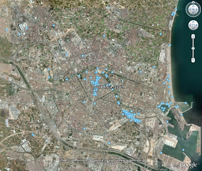
Valencia, Spain case study post, I stated that one "crowd-sourced" data point I like is the geotagged uploaded photos into Google Earth filed under a page called Panoramio. They're also a favorite treasure trove of photos for the Free Beer Friday Guess the Cities. What they show is cherished or sacred places of a community.

**note: for later in this post be aware that Google Earth changed the symbol for geo-tagged photos from a glowing light blue star as seen below to a more regular (and bland) blue square that is a bit less conspicuous unfortunately.


Of this map of Valencia I said:
As for the organization of the city, my favorite little cheat sheet, the blue dots of uploaded photographs shows what we're looking for, following the curve of the river with a North-South axis of the heart of the city intersecting it. This is the oldest part of the city with the two most important plazas, culturally, spatially, architecturally, historically, you name it: Plaza de la Reina and Plaza de Ayunamiento
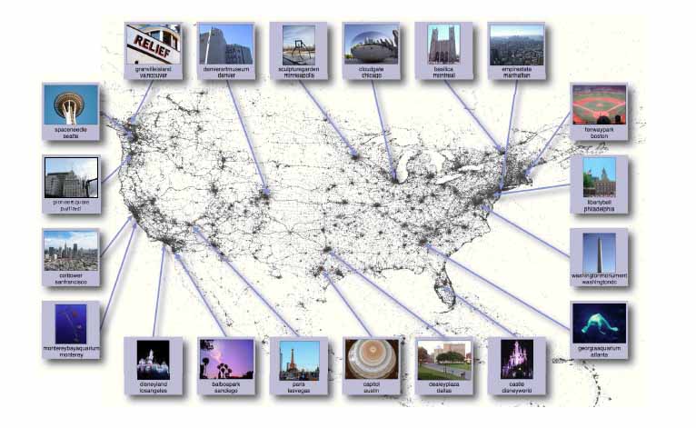
Now brought to you by the computer science department from Cornell University is a mapping study of 35 million pictures uploaded to flickr. They then organized a database counting and comparing pictures by popular location or landmark and by overall city. If you were to take a wild stab at the three most popular cities, you'd guess what? NYC, Paris, and London. Maybe Tokyo, if you're feeling a touch 'Asiatic.' If that was your guess, congratulations! You only matched my guess, which was actually a touch off from accurate:
The top 25 most photographed cities in the Flickr data are: (1) New York City (2) London (3) San Francisco (4) Paris (5) Los Angeles (6) Chicago (7) Washington, DC (8) Seattle (9) Rome (10) Amsterdam (11) Boston (12) Barcelona (13) San Diego (14) Berlin (15) Las Vegas (16) Florence (17) Toronto (18) Milan (19) Vancouver (20) Madrid (21) Venice (22) Philadelphia (23) Austin (24) Dublin (25) Portland.

If you accept that the places we photograph most are places we love, then it is probably safe to assume that the cities we photograph the most are the cities we love the most. If you are to put together some common traits of the cities floating towards the top of the list is interesting, educated, fun, and in most cases livable or outrageous cities. And, in fact, because Dubai doesn't make the list and Las Vegas does (as does Disney World for the place specific list), but I would suggest these are outliers because Vegas is what it is and Disney World is unfairly competing as a huge place with multiple photogenic or not spots competing with singular monuments, parks, or places.


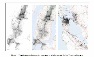
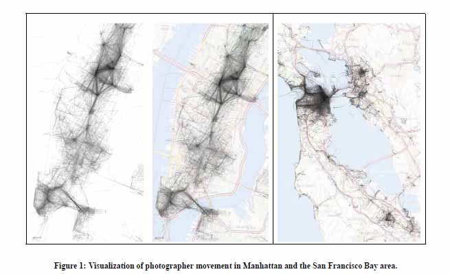
Then, where it really starts to get fascinating is marking the movements of photographers, if by only charting where their pictures were taken. If you analyze the places, you begin to see areas of livable, lovable concentrated points or nodes, typically occurring at areas of convergence. The Manhattan map is probably the most interesting given how few photos are of or near the waterfronts. I think it is safe to say that we can attribute that to Mr. Moses' riverfront highways and associated deterioration and degradation of the public realm adjacent.

The one outlier is the Brooklyn Bridge, adding 'convergence' in that it is both monument and connector. It hit me today that there needs to be a 1-dimensional convergence to go with my other three versions, 2-D (Plan view), 3-D (Mix of use and density), and 4-D (multiple modes of transit/time of day). And it is actually the simplest one of all as it should be, demand driver. There has to be a reason for me (or you) to go from point A to point B in the first place. It can be economic, it can be social, it can be spiritual, but it has to exist.

I think this also gets at another point, and that is that waterfronts can actually be tremendously overvalued in terms of dollars and in the collective conscience of a community. Views can be nice residential demand drivers, but are really only suitable for more single-use development or iconic elements to be viewed. The more vibrant social and economic hubs, as the NYC map shows happen internal to a city, in its neighborhood centers, its areas of convergence where we meet, greet, and celebrate.

If we look at two cities ranking on the list with more engaged urban waterfronts you'll see the sparse assortment of only a handful of pictures.


Along the Willamette River in Portland where they removed a freeway mirrored on the opposite side to create a riverfront park.


New waterfront park in Vancouver, BC.

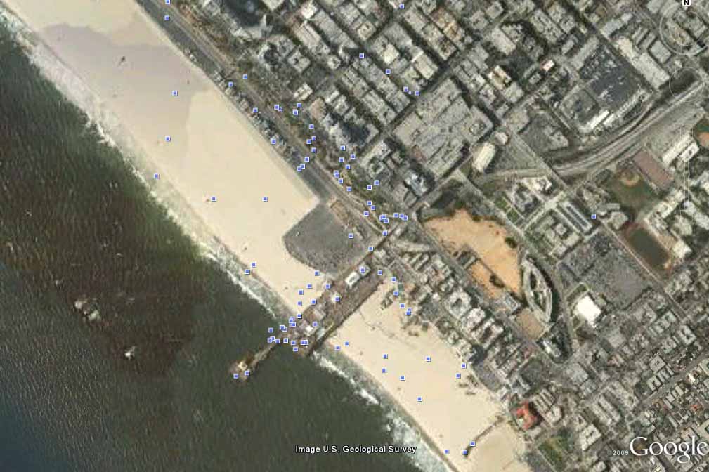
What is an outlier for waterfronts that ranks high in the Cornell study for individual places? The Santa Monica Pier, because it creates its own convergence by extending destination space out into the water so that the boardwalk/beach is no longer an edge but a crossroads of sorts... the very essence of convergence.