Thursday, December 15, 2011

Intersection Density, Disinvestment, and Decay

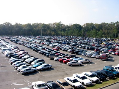
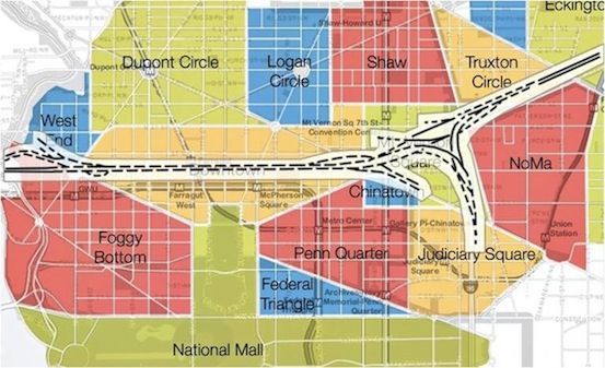
On twitter this morning and in recent discussion about the West Dallas Plan and its relation to the contentious Sylvan:Thirty project I've been writing/talking a good bit about block structure. Particularly, block size and the surrounding network, its complexity and interconnectedness as measured by intersection density. I have several contentions regarding the West Dallas Plan, but as it regards to Sylvan:Thirty, I found the biggest glaring weakness is the lack of definitive block size. There are no maximums. Therefore, there is no certainty that a complex, interconnected, safe, desirable, walkable urban neighborhood will ever emerge.

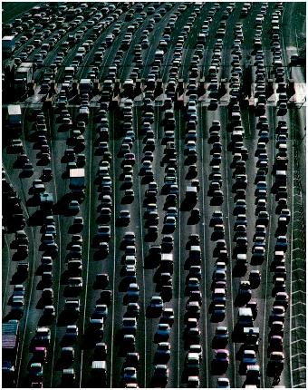
This centers on the work by Prof. Norman Garrick at the University of Connecticut, who has shown direct correlation between intersection density and the safety of an area, modal share, and walkability. I find this to be not just correlated, but causal and predictive as towards the future value of a neighborhood. Limited network density, means decreased mobility, increased risk of severe injury, therefore less desirable, and ultimately less valued by individuals, the market, and eventually investors. They often don't realize it well until the place has cleared out and its lost critical mass and then real estate values plummet.

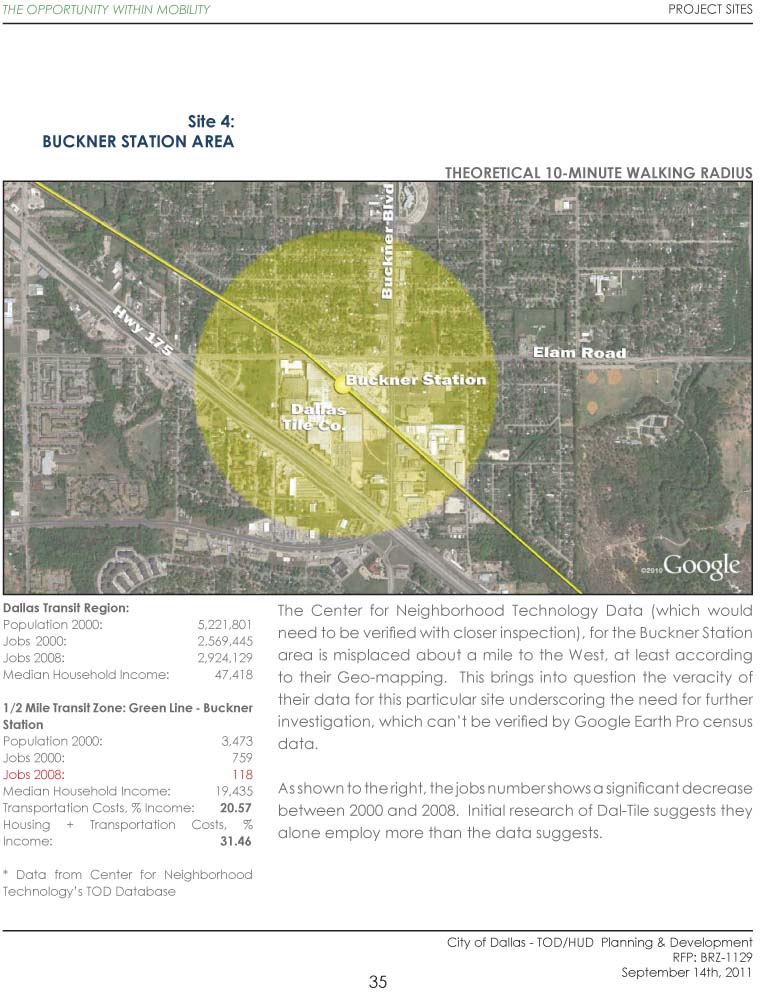
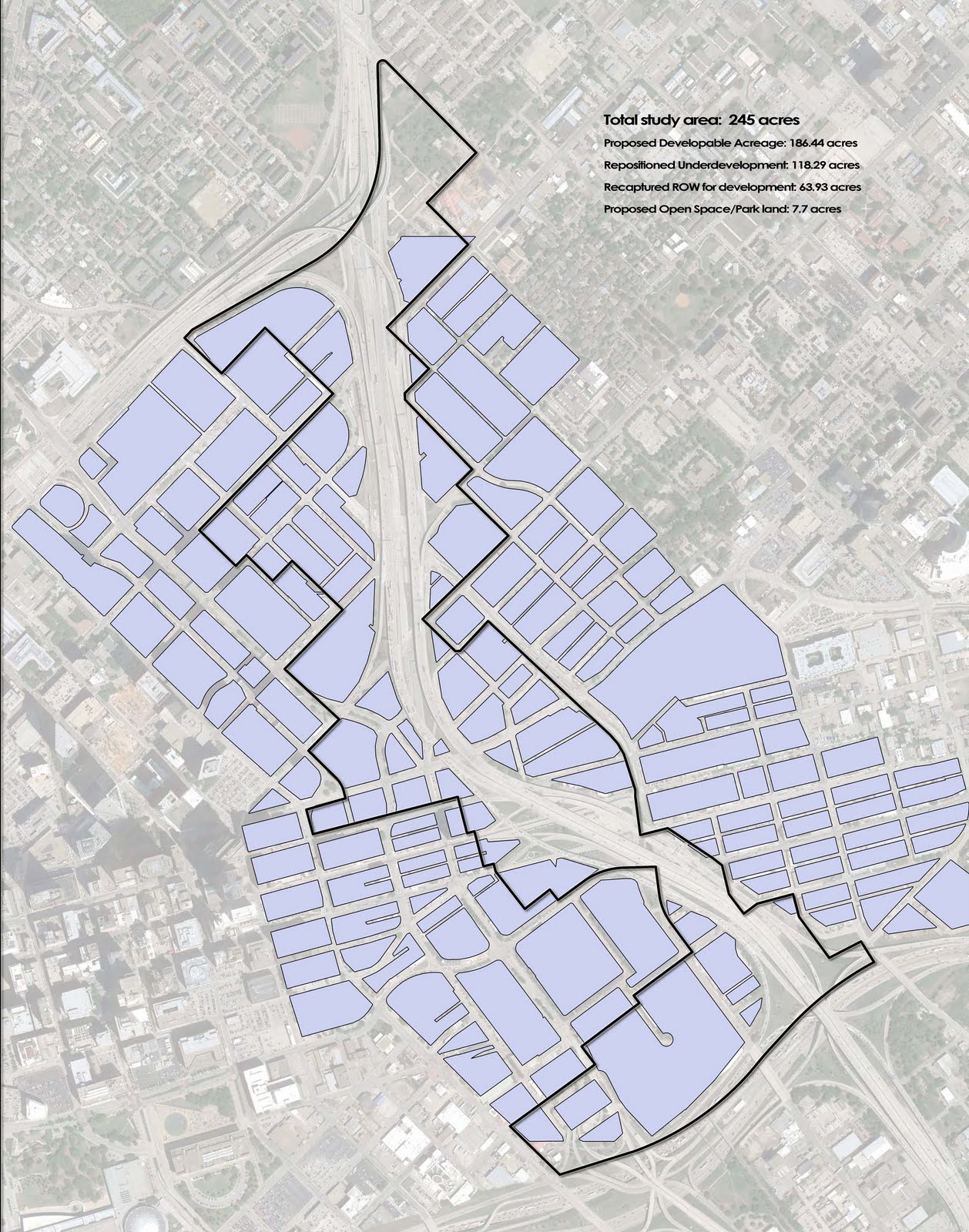
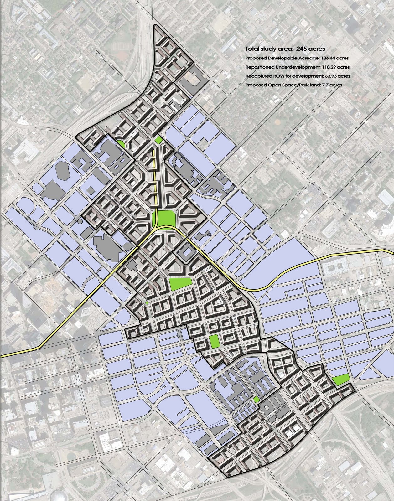
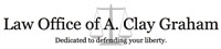
This fall, the City of Dallas initiated a new planning project focused on five DART station area plans. All are in rather desperate areas and the plan is that after initial planning efforts, each will have a first phase of affordable, workforce housing for the kind of people that need to be near DART station in order to have mobility so as to not have the mandatory expense of car ownership.

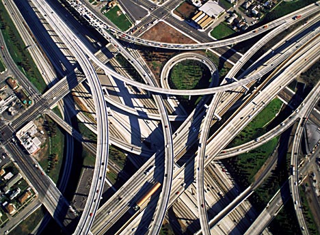
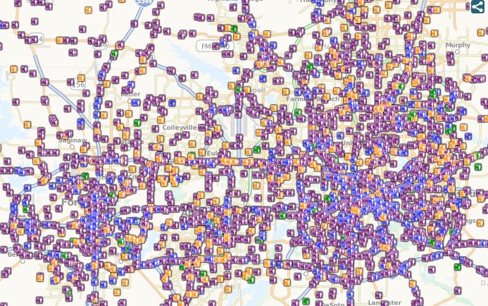
However, DART is only one form of mobility, regional mobility. There also must be local mobility. So when going after this project, I put together the following studies showing intersection density and real walkability as opposed to the typical 10-minute walk circles. (The project has been given to Fregonese/Calthorpe)

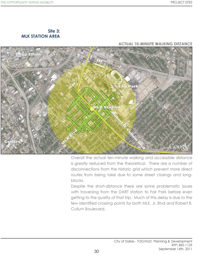
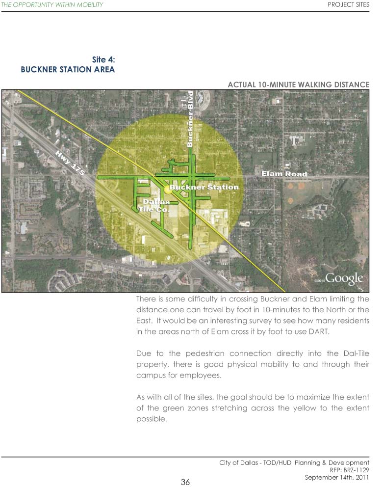
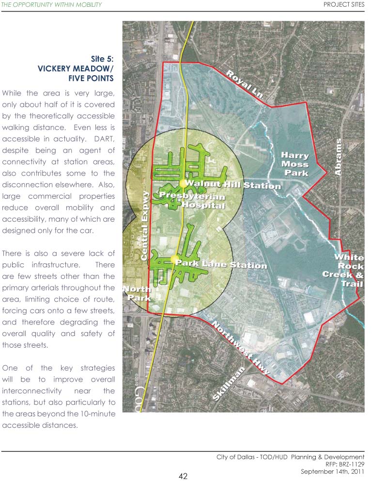
Also, it should be noted that distance-based walkability is strictly an objective measurement. How far can you get in ten minutes? What is within convenient reach? In the following imagery, I'm only showing that study. I've left out the subjective analysis (as you can see pages are missing), which shows imagery of the character of the environment: boarded up buildings, vacant lots, parking lots, broken or non-existent sidewalks, big bad roads, etc. etc. i.e. the kind of things that make walking feel or seem unsafe, unpleasurable, and undesirable.

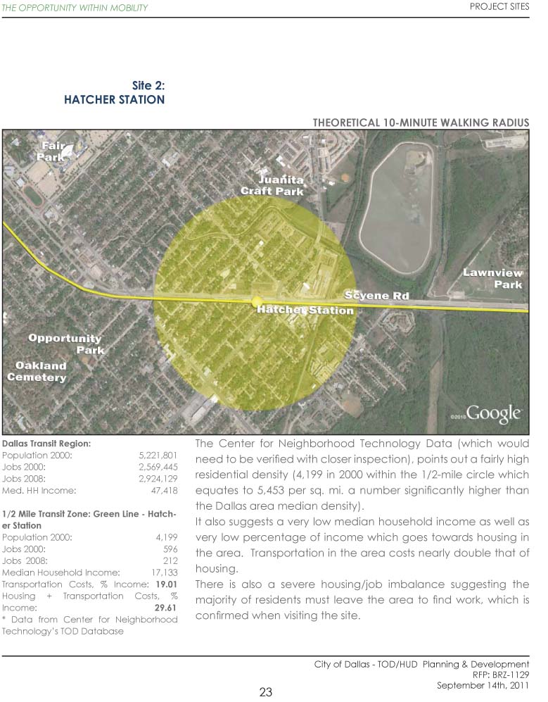
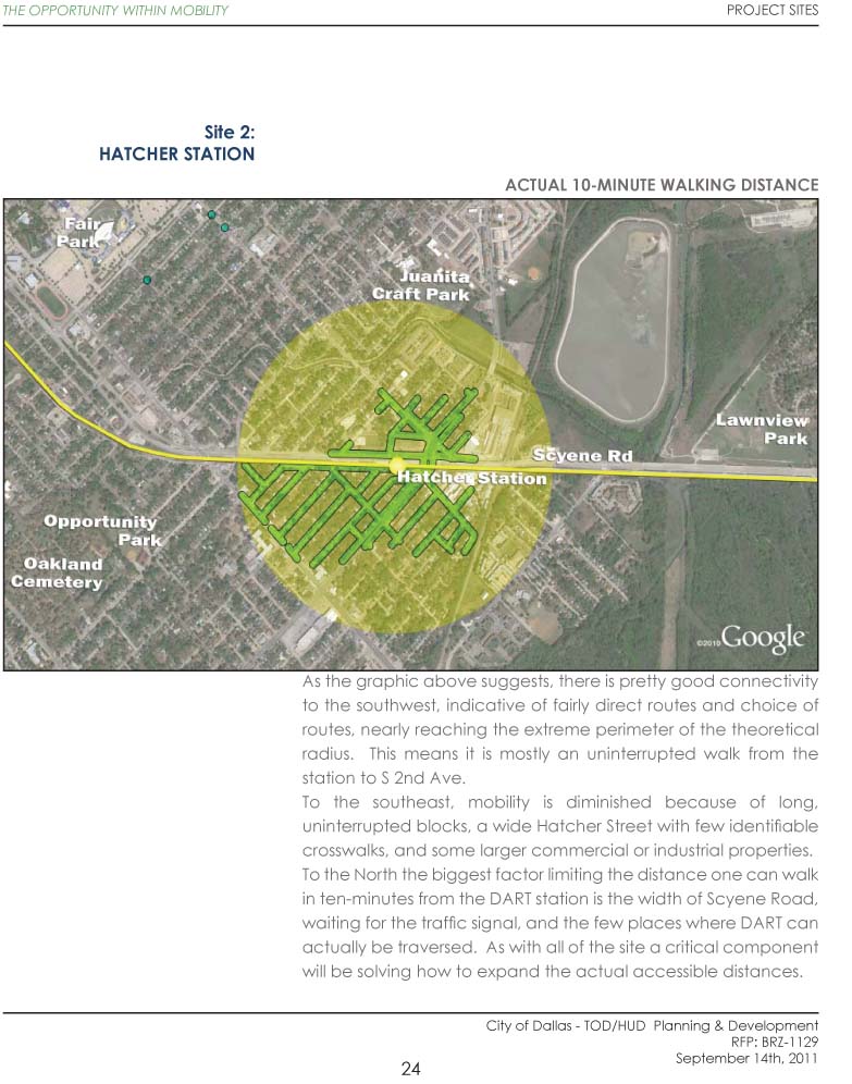
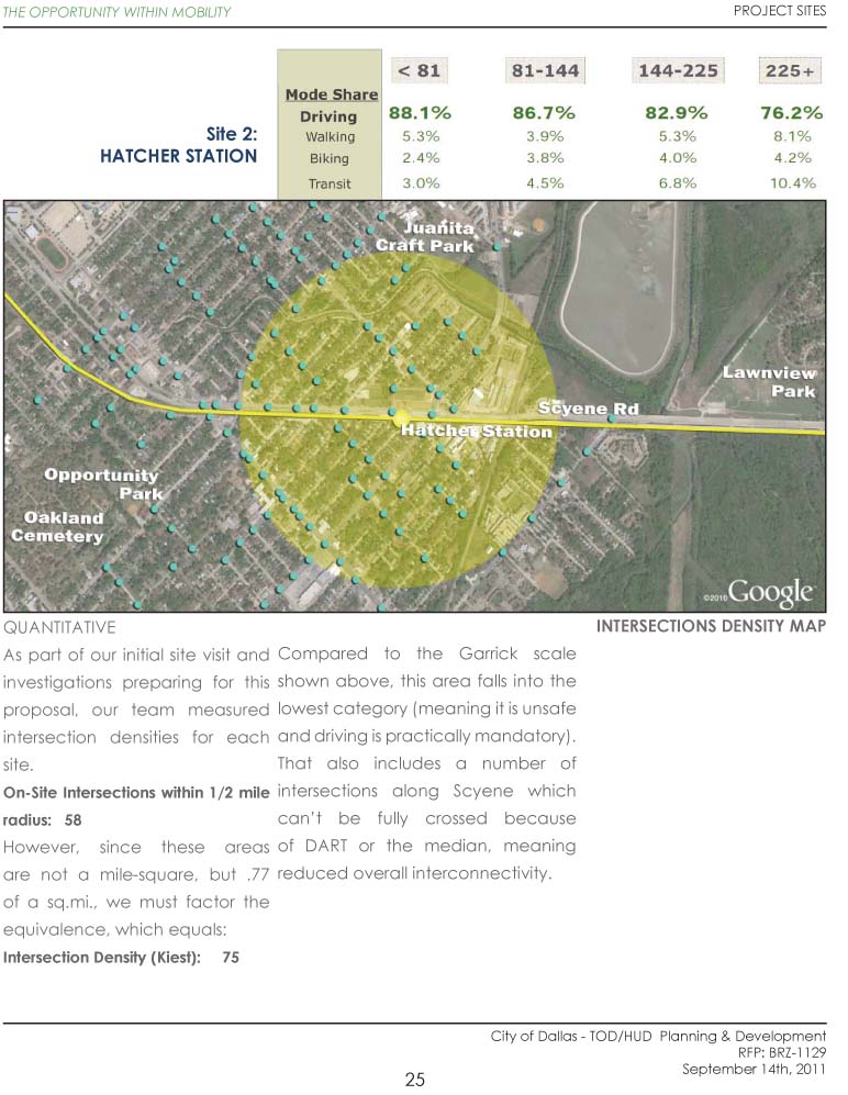
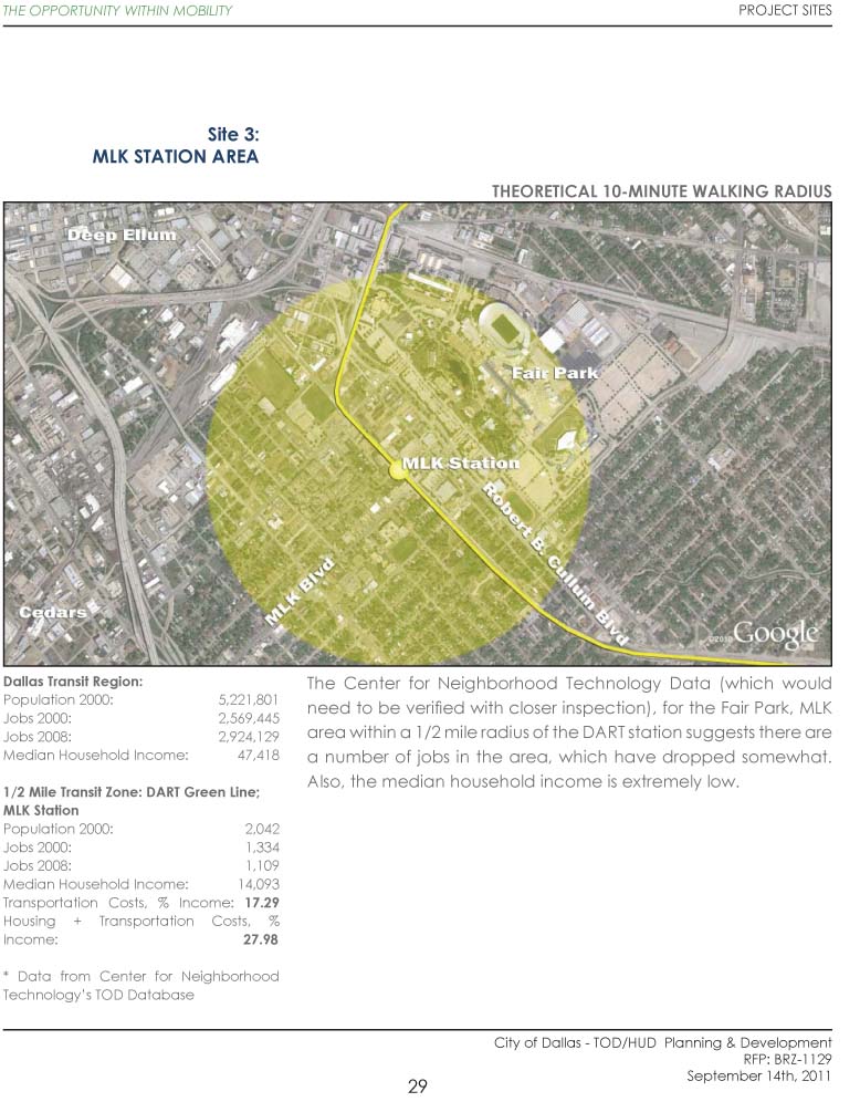
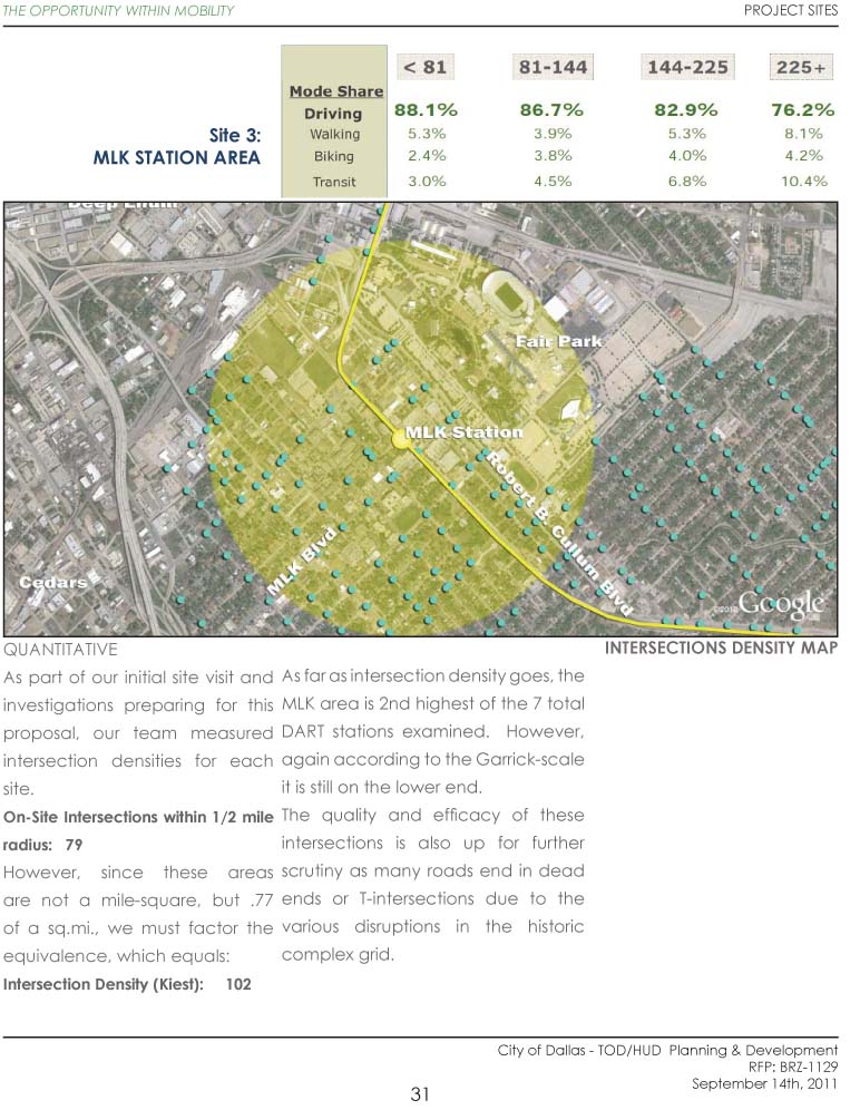
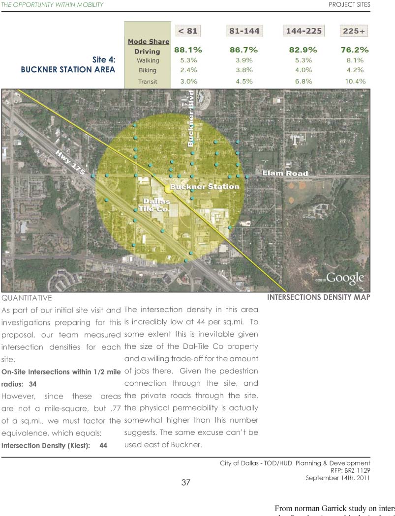
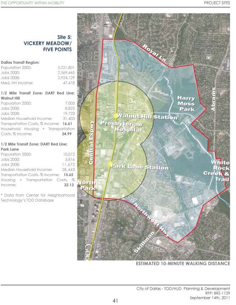
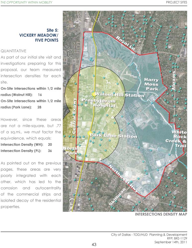
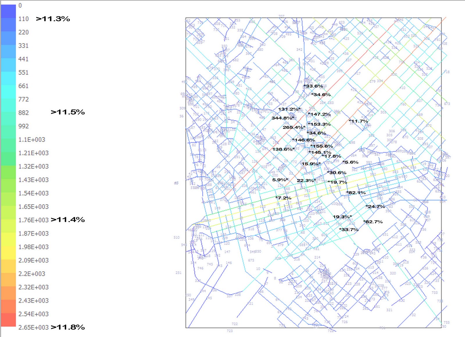
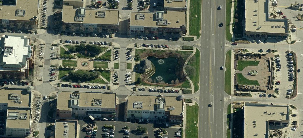
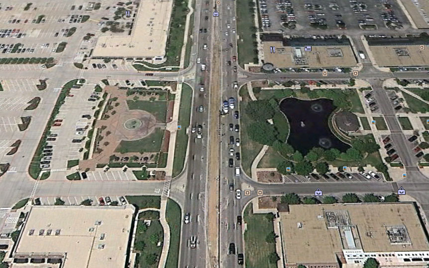
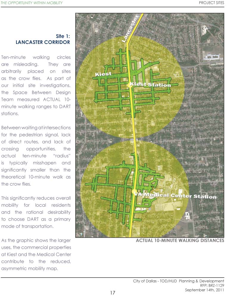
Each study area gets three pages. The first shows the demographics in the study area. The second shows the real world ten-minute walking distances in relation to the theoretical ten-minute walk circles. The third page shows intersection density. It was my point that the areas became run-down because of the lack of real, quality public infrastructure in the way of an interconnected, dense network of streets and blocks.

See (and click to embiggen):


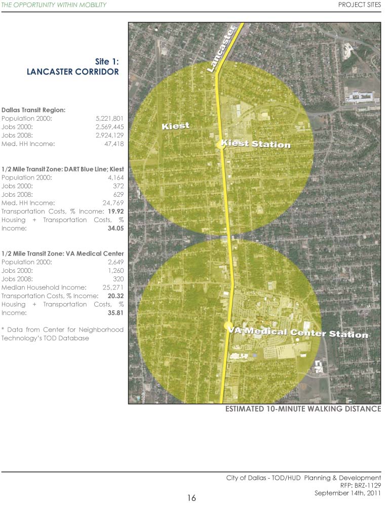
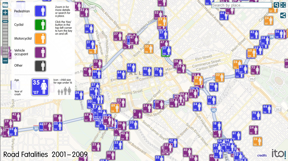
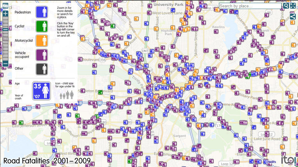
Yellow shows theoretical walking distance. Green shows actual 10-minute walks.

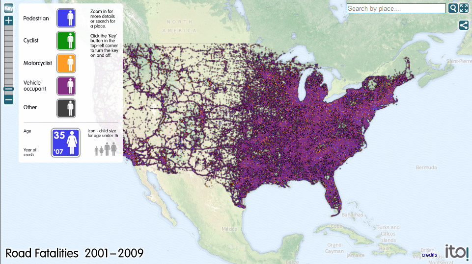
Blue dots show intersection density and on each page I show the calculation of intersections per square mile. Garrick's work shows that walkability, safety, and in turn desirability, really jump at around 225 intersections per square mile and up. All of these are much, much lower. Most of which are sub-100.

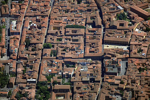
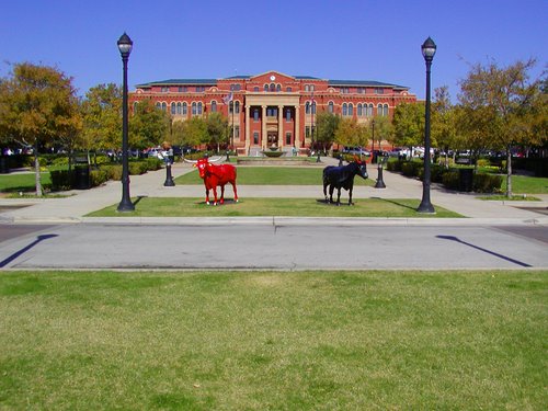
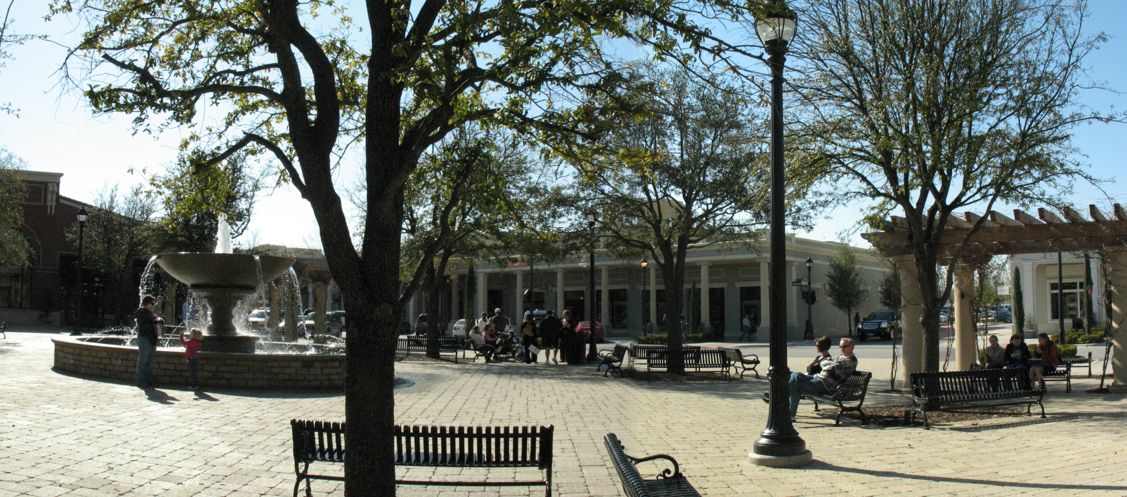
As a contrast, State-Thomas neighborhood, one of the best examples of neighborhood revitalization in the country after the area was gutted by S&L; speculation in the 80s, has 253 intersections per square mile. It's average block size is about 350x325'. The Pearl District in Portland, another example of revitalization, has a typical block size that is even smaller, 225'x225'. In turn there is a very tight network of streets, yielding a highly walkable intersection density of 447(!).

Thus, we can begin putting together some predictions that any revitalization must be tempered and potentially unsustained if we don't significantly raise mobility and safety of areas through increased intersection/network density.


Wednesday, December 14, 2011

4 Types of Cyclists


This highly effective little graphic comes from a white paper produced by Roger Geller. The key to bike ridership is not converting the "Interested but Concerned" into "Enthused" or "Fearless." Changing people is far more difficult than changing the infrastructure (unless you are the City of Dallas).

Instead, you have to tap into that population base. But why?

For one, despite the various regional geographies and mindsets we might personally identify with, these percentages are pretty consistent no matter where the question is posed. Portland, Dallas, or Amsterdam. The difference is how amenable the infrastructure is.

Second, this:

and this:

Is far safer, cheaper (for city and individual), more spatially & energy efficient, and healthier than this:

or this:

Or this:

How much longer would you like your income heading towards these things? At some point, the choice will no longer be yours.


Thoroughfare Plans and the Downward Spiral of (un)intended Consequences

The delay in the bike plan has raised the rabble from the woodwork and apparently really touched a nerve within those active, engaged, occasionally hopeful and sometimes cynical towards Dallas' efforts. Certainly this is partially due to the popularity and interest the bike plan had going into it. There must also be a growing sentiment that all plans, those that the citizenry really want and need, or perhaps only feel deep within their bones of intuition, are the ones that always fizzle. That only sit on shelves as plans for planning's sake.

Meanwhile, the world's ugliest building is finishing out. Soon to eclipse the previous holder of the title. Both local. All of that gets done because it's easy. It sort of strikes me like the South Park episode about Magic Johnson curing AIDS. "Just inject it with $250,000 worth of liquified, concentrated cash." It's not the city's money (for the most part), at least not yet. Until they start getting the maintenance bill or wish they had preserved some land for actual tax generated private property.

The map of downtown Dallas when you black out parking lots or garages, vacant buildings/structures/lots, as well as non-taxable entities (churches and civic facilities) is not pretty. There is a distinct imbalance between tax base, what might be called the vanilla ice cream in the sundae, i.e. the foundation the cherries sit upon and those cherries. All the big wow projects we get and then just sit.

There are a few abstract, generalized formulae I like to point to in order to explain how urban dynamics and morphology work. The first is that any place, area, city, or neighborhood exists within a continuum:

Macro Level:
Viable ---> Livable ---> Memorable or Lovable

and...

Micro Level:
Integration begets Accommodation (usable land uses, entrepreneurial opportunites, ie demand) begets Decoration (detailed design improvements)

Of course, there is a degree below viable which is not viable for concentrated human habitation. There is no opportunity there other than agriculture or nature. The degree which a place sits on that continuum is defined by its level of integration, locally, regionally, and globally. How connected it is to everything else. What we find is that often the infrastructure for global and regional connectivity often disrupts local connectivity, reducing overall integration and thereby dropping the level perhaps from Livable to merely viable. These include airports, shipping ports, rail hubs, highways, large arterials, etc. Likely as some kind of shipping depot, light industrial that wants to be by an airport, or gas stations/strip centers that want to be on regionally connective freeways.

What happened to many of the downtowns in the U.S., particularly in the Sun Belt was the fervor with which they pursued regional connections at the expense of local integration, that which can be safely and enjoyably walked, if one so chooses. There is an extremely high degree of mobility. After spending some time in Barcelona this summer, I'm not sure I can point to a better example. You can get to just about anywhere in the city, to all of your needs, near or far, quickly and expediently. Only on the rarest of occasions do the regional connections disrupt the local:

Notice the development around it has been ripped to pieces. Sure, things will infill, but the character is so poorly defined and integrated that it will never hold up to the rest of Barcelona. The eternal cooperation and competition between and within cities. It should also be noted the other Norman Foster phallic high-rise is right there. It's a common response to failures in the network to overcome them with extravagant buildings. Sometimes you even make it super shiny and glowy to cover up the degraded ground plane. Sound familiar at all?

Often times those destinations are close. You can walk across the street to them. Because I live in one of the few places in all of DFW where it is possible to get to everything I need within a few blocks including transit, my velocity is quite slow. Much slower than suburbanites getting to a their local Appleby's or whatnot. However, I can get there more predictably, more quickly, and while expending much less energy. The average Barcelona resident burns one-twelfth of the gasoline than does the typical Sun Belt resident. Little side note for you.

There are two problems here. One is the way we measure traffic efficiency and rate roadways, which is entirely by speed of movement. This is essentially coded in a way to always, ALWAYS favor car traffic and thereby sprawl as well as dangerous roadways. Why sprawl? Because the formulae used will always say that only more lanes are necessary, widening of all roads in order to improve traffic flow. The reason is because it is a broken system with an impossible end game. The optimal condition is NO cars on the road. Every other car is the enemy and an impediment to your and everybody else's trip. Hence, why you hate them, flick them off, curse them, and get out of your car miserable. Or was that just me?

Because the solution to every question is bigger roads, and the cities happily take the federal money, the cities end up gutting their own tax base. For every percentage increase in lane miles, ie size of roads, there exists a 1 to 1 increase in the VMTs driven by the citizenry. Meaning, the more roads that are built, the further afield everyone lives, the more everyone drives. Bigger roads invariably lead to a further spread out population, with increased infrastructural burden, lower density to pay for that infrastructure, and thus it is all failing. Every part of the system, from the financing and budget to the physical integrity of the actual structures themselves:

Because all cities and metro areas are required by federal law to create thoroughfare plans they must categorize every road. Furthermore, because of the way fed/state money is prioritized towards the bigger roads (highways and arterials) there is an incentive for cities chasing money like crack fiends to upgrade, reclassify, or "improve" roads towards the bigger and badder. These interupt the fine-grained local connective tissue of neighborhoods. It decreases downtowns steadily, with each new road from Memorable down to Livable and eventually down to barely Viable.

Meanwhile, land formerly out in the boonies, in places we now know as McKinney, Plano, Allen, Frisco, etc., went from not viable, to Viable, to Livable in some cases. It remains to be seen how many can remain livable and/or viable on into an increasing unclear energy future. I've written before how cities are always defined by the newly emergent transportation technology and how that technology is now the internet, smart phones, etc. The ability to be connected long distances (regionally and globally) somewhat effectively reduces the demand for regional and global connections. Sure, they're sometimes still necessary, but not to prioritize them while de-emphasizing the local. The local is density. The local is where people collaborate, innovate, interact, and invent. The local is what we must prioritize.

For a brief read on spatial integration, the math and measure of it, and how we decreased the level of downtown Dallas integration and connectivity, thus undermining demand while adding supply of speculative office towers, much of which have emptied out, please see here.


Tuesday, December 13, 2011

DC, More Like BC

As in "behind the times," amirite? They so could've built this:


Think about how many of those pesky buildings are in the way, that could've been knocked down to make way for gas stations and parking. Oh, plenty o' parking. Cheap, plentiful, convenient parking lots. #progress #economicdevelopment


Day in the Life of a Pop-up Street Cafe

Location matters, of course. Integration --> Accommodation --> Decoration. Though this is more of a parklet than it is cafe space for the restaurant that paid for it. Would a few tables help or hurt? Having only the common bench seems to make it rather inviting where tables might discourage the public nature of it.

Unloading

Rudy Bush, the DMN's city hall beat reporter asked me to weigh in on the latest delays, objections, etc. with implementing the city's new bike plan. You'd think those issues would've been voiced and addressed long ago. Land mines. Makes you wonder about the entire process. I feel for Angela and Scott on Dallas City Council. They're trying. They're really trying. Here is my response, cross-posted from the DMN's blog:

Well, there are a few issues at hand. From the way I understand it the time and delay really stem from the transportation committee, which is hesitant to lose any traffic lanes dedicated to cars. Meaning, it isn't just as simple as re-striping existing roads whenever they're due for re-painting, which would be the cheap, logical, and expedient thing to do in the appropriate locations.
Second, it strikes me as disingenuous to throw numbers around for an entire system buildout that could take who knows how long or how many different projects it would entail. The slow down makes the study and planning effort look a bit like a sham, which is a real waste of money. It should also be noted that I've never seen as many people at a public kickoff as with this bike plan. People were excited.

Contrast the way the city is operating here with how Fort Worth has been enacting bike lanes - incrementally and effectively. I find it amazing that the Better Block Project was invented in Dallas, yet there is no evidence of results from those events. Meanwhile, the city of Fort Worth made those changes permanent.

This has an economic development component to it as well. The Magnolia Avenue corridor's sales receipts have jumped from (and if I remember the numbers correctly) $2 million last year to $11 million in 2011. It was simple re-striping, one street at a time. Meanwhile, as I joked on twitter Monday, we're spending how much on Calatrava to redesign a bridge (which as the existing Calatrava Bridge suggests, he'll probably just copy his own design again (see: Reggio Emilia, Italy)), a silly idea and engineering study for a Ferris Wheel, etc. etc.? If they think that is economic development, then I have another bridge to sell them.

Part of economic development is being cool, which is invaluable. In fact, that is probably the biggest element to long-term economic success, in attracting businesses and talented individuals. They want to go where it is cool, where it matches their lifestyle. The bike and its relationship to what is cool, mostly through Millennial generation nostalgia, can't be overlooked. In the same way that Boomers saw James Dean and cars as a form of freedom, I really think my generation and younger, those dependent upon mom or the school bus to drive us everywhere growing up, saw the bike as our independence.

When people have choice in transportation and can make their own decisions rationally, based on their particular needs for a particular trip, that makes a truly "smart city." It builds intelligence into the operating system by empowering the users if there truly are rational options. Biking, like many other forms of transportation, is virtually impossible here, which is expressed in the numbers of people who actually do it.

Another mistake is to make transportation decisions based on existing land use and density. For example, everything is far apart and rather inconvenient for anything but the car. So the ignorant use this, saying, "Well, everything is too far apart to bike." Of course, it is. Because the transportation system is built only for the car, so the land uses and development patterns respond in kind. If you provide adequate infrastructure for other forms of transportation, the city and the real estate market will adapt.

Now look at the cities that everybody is dying to live in, be in, visit: New York, Copenhagen, Vancouver, Barcelona. These are cities that have been focusing not just on bicycling, but on balancing transportation, with legitimate choices in modes and routes of transportation. We like to throw around the term "world class," but those are really world class cities. They don't need to puff their chest and boast about it as some superficial fabrication.

In other news, here is the map of traffic fatalities in DFW Metroplex 2001-09:

Tuesday, December 6, 2011

The Integration Increment


This is in relation to this.

Oh, addendum: here is a little background information:
High integration means high value in the "movement economy," i.e. access and the commercial viability to capitalize on it. This then in turn means high level of service (commercial) and amenity. Which then, in turn, ought to mean high level of demand for residential proximity to said amenities. In theory, it and the process to deliver the above, means a full urban ecology in bloom where each nourishes the other in positive feedback loops.


DFW Squares/Plazas, Chapter 3

As you may know, I've begun a bit of a recurring examination and perhaps critique of the plazas and squares of DFW. You can find part 1 here and part 2 here. Admittedly, this may be short-lived since there just might be less legitimately integral plazas to the overall movement and land use network in all of DFW than in Siena, Italy alone (and I specifically chose an aerial that ignore the Campo):


I'm going to review two by request today, Southlake Town Square and the Eisemann Center in Richardson, both of which have been built within the last ten or so years. Keep in mind the word integral mentioned above, because that is what gets lost in the majority of our attempts at these single-purpose, off the shelf, attempts at something loosely called "sense of place."

In other words, it has been completely bastardized for marketing purposes as our transportation, real estate, and placemaking, i.e. people places, have all lost sight of one another when they ought to be intertwined. That gets too in the way of the road builders and "efficiency" pursuers, even though the end result of their labor is the antithesis of efficient.

First up, Southlake Town Square: Suburban, OK.

Southlake Town Square Court House

The first thing I notice regarding the primary square at Southlake is its scale that would make emperor's blush. Three football fields side by side can fit within the building envelope. Likely intentionally large to allow for large gatherings, it isn't exactly designed to suit events, lacking a bit of flexibility in its intent. I imagine the large pond and fountain collects some of the runoff hence its relative lack of accessibility. If the water is purely functional, I imagine it could be collected somewhere else.

Sure, it looks nice, but the fact that you can't interact with it, get down to the level and touch it, detracts from its aesthetics. Furthermore, being that it is sunken creates a weird spatial environment in such a large open space, that I get a bit agoraphobic thinking about it. Of course, I'm open to corrections if you can get down to it.

The larger issue is the relationship between building height and the distance between building faces, i.e. the width of the space. Like it or not we're still cave people. We like feeling as though we are within confined spaces. The rough max building height to open space relationship where we still feel as though we're within an "outdoor room" is about 1:5, say two 20' tall buildings separated by a 100' wide space. The relationship at Southlake looks to be about 1:12, hence agoraphobia.

I also question what this does for the commercial environment, since cross shopping is divided by such a large distance. Contrast this with my favorite part of Southlake:
Southlake- A Town Square PlazaI give this space an A+, given its context. It feels nice, it doesn't try to do too much, it feels integral to its environment.

Perhaps that is another part of the problem with the main square, that it is divided by the large arterial Southlake Boulevard. This is rather natural, you want to get people off of that road, because duh, it's an awful road. So instead of improving the road (unthinkable!), you create a road side attraction and make the experience off-center from the road:


If you buy into the work of Bill Hillier and Space Syntax, you know that any/every deviation from the primary axis or energy source, that being the arterial, is realized by an incremental loss in value.

Except, they are improving the road according to the latest google earth aerial!...


Or not. Actually, it just looks like they are adding what I presume to be a grass median. This is "improvement." The road isn't being narrowed, still three travel lanes on each side. Traffic isn't being slowed. And perhaps even worse, they are blockading connections between the two sides of development. All through movement, no stick around movement. No gravitational pull.

Other than the arbitrary shrubbing and overly wide scale of the square, it's about as best we can do under the iron and ignorant fist of traffic engineers.

Eisemann Center, Richardson. Grade, Incomplete.

I'm not quite sure what to make of this yet. This has been a long time in the works, yet the development has filled out slowly. Very slowly. In fact, the plaza, I suppose, isn't even yet fully enclosed. That is, if the plaza is what seems to be more of a pedestrian promenade between the DART stop and the performing arts center.


It can look great with the proper framing and optics! Stepping back a bit is where the confusion sets in...


As you can see at the bottom left, the last site hasn't yet filled in. I'm confused as to where the center of this place is. Again, it is presumably the axis running left to right on this image. However, the placement of the garages and office buildings is clumsy. I guess the office buildings needed to interact with some abstract landscape rather than a potential people place. Meanwhile the garages occupy two corners of the primary junction point of the place.

However, even if the last parcel were to fill in, I'm skeptical the critical mass is there to bring the place to life. I think the scale and minimalist design of the plaza will be perfectly fine and nice. With the highway acting as a barrier on one side, less than a quarter mile in the other three directions, whatever they're trying to build here runs into awful suburban arterials and disconnected office parks, none of which have much of a relationship between each other. Precisely why the value will be sucked right out of all of them. Hopefully the Eisemann and its context can stay strong, providing the seed of regeneration when all else fails around it.

Not a Pedestrian Mall

Janette Sadik Khan has hit it big. Main stream media is picking up on the wild and crazy ideas of actually improving cities:

Video link here (sorry, no embed code)

This isn't about de-car-ing the city or pedestrian malling and this particular solution won't work just anywhere. Every single place across this country will have its own special calibrated solution. This is also not to be confused with pedestrian mall-ing of downtowns. What they did in NYC is improve overall mobility, which is precisely why business has improved. Not because it is pedestrian, but because it is more fluid. More pedestrians can fit in Times Square than cars AND the only time they're congested is on New Years Eve.

Monday, November 28, 2011

Mexico City Gets It, Bikes & Pedestrianization that Is

From conversations with several friends who are from the Distrito Federal, it seems to be leading the way back from the brink in Mexico as cultural capitals tend to do. From their estimation, this is largely due to a generation from 22-35 or so that have been educated elsewhere, traveled the world, seen other places, and have returned home to start programs/businesses like their bike sharing program. When new ideas gain a foothold in a place there is naturally a backlash by conventional wisdom and the preservation of the status quo. Ideas are always battling, competing for critical and decisive mass in order to assert themselves. Witness the memetic competition in action:
This past summer, Mexico City radio station Imagen was forced to place one of its commentators, Angel Verdugo, on indefinite suspension over disparaging remarks he made about the city’s bicyclists. Calling them a “new plague,” Verdugo also accused the bicyclists of putting on “European” airs. The commentator reminded them that Mexico City is not Paris, and that “here is the concrete jungle.” As if that were not enough, Verdugo invited drivers to “throw their vehicles at them, immediately.” Not surprisingly, the statements provoked widespread outrage.
Of course, and inevitably, the best ideas always win (eventually). The new idea always has to bear the burden of proof. And slowly but surely we're all learning it, sharing it, spreading it so that the world can be a safer, more fair, more just, more opportunistic and empowering place to live:

In the 1950s, Mexico City was redesigned along the model of U.S. cities like Los Angeles, with a focus on large suburbs and grand avenues. That, in turn, made the Mexican capital dangerous for pedestrians. The current government is trying to reverse that trend by putting pedestrians and cyclists first. The biggest challenge, however, may be getting the city’s drivers on board. Car owners are used to being kings of the road. Even so, at least in the areas where the new measures have been implemented, change is brewing.

City authorities say that reducing the commuting time will have a direct economic effect. For starters, cars are expensive. “It’s estimated that an average person has to spend three hours worth of work every day to pay for a car,” says Jesús Sánchez, a private consultant. Cycling and walking are far cheaper. They’re also healthier, and therefore less burdensome on the health system.

The costs of a car-based system (city) are exponential, as our burgeoning debts, both public and private, attest. Likewise, the savings AND beneficent profits (socially, environmental, and economic) of a less-car dependent system are similarly exponential. But in a good way.

Spreading Out, Back In


The above image is from the print edition of the Charlotte Observer. It is pretty self-explanatory, showing the enlargening, broadening of the poor. Of course, the poor are still huddling up as close to the urban core as possible, which might otherwise be known as opportunity areas (for better or worse, mind you).

The other interesting note is the bifurcated pattern of the wealthy, which is pretty observably replicated in every other American city. About half are moving into defensible, monocultural enclaves far out from the core, while others are repopulating the center, otherwise known as high amenity areas.

As for the poor migrating outward, in many ways being pushed out to area where they must "drive til they qualify," which really isn't the poor as much as lower and middle classes getting squeezed toward the poor end of the toothpaste tube, Charlotte in particular has been in the news quite a bit for the rise in criminal and drug activity at the edges. I don't find this to be unique to Charlotte either.

I don't find either to be particularly "right" or "wrong," but rather both quite natural, with examples throughout history. The well-to-do could have country manors, simply because they could afford it (of course, this also necessitates extreme wealth, the kind found in the various gilded ages) or they possess the best, most desirable property, that within the city boundaries.

A good example of this might be Rothenburg, Germany where the most wealthy had peripheral castles with servants, essentially their own private, nearly self-sufficient mini-cities. While the next class of wealthy, often merchants, occupied their particular version of the "high street" or "main street." Their houses were ornate, and highly concentrated along the radials stemming from the marketplatz, with more spartan dwellings toward the periphery.

The highest value area, the area of the highest "convergence" or spatial integration (that is til other cities surpassed Rothenburg's purpose) had the greatest amount of density and ornament, i.e. accommodation. Integration begets accommodation (which might have a subset called "decoration" or "ornamentation" -- both by-products of demand of density).

Rothenburg
The lower density and more affordable wants to get as close as possible to the integration or "convergence" points, the areas of opportunity. Rothenburg is interesting because it is so small that there is really only one major identifiable one, with a few others scattered at the edges where the radial or "entry" streets intersect with some of the smaller "orbitals" or the outlying streets.

Point being, there is always some measure of natural order occurring within cities as they shift shape, mold, expand or contract, and they all come down to desirability, opportunity, individual wants and needs. Though, what people can afford and how many can afford it, is a critical component to the "weight" or mass of the movement dynamic.

Wednesday, November 23, 2011

Traffic Deaths, Mapped

Here is a link to a pretty incredible site, a map of every single traffic related death in the US between 2001-2009. Nationwide:


Blob of purple. Says little. In fact, this would be more informative I think if it was then overlaid with a graphic emphasizing per capita deaths by city.

Nonetheless, awesome and terrifying. Like any natural disaster. Except this isn't natural, but entirely manmade. And no, I don't find it overkill to remind that Copenhagen has a goal to reduce traffic-related fatalities to zero for an entire year. It's good to have goals. In the last year, they had 5. It's better to have goals that can be met and measured. What are ours?

Let's look closer at downtown Dallas:


A few things jump out. First, the two dominant color-coded deaths: blue for pedestrian and purple for passenger/driver, make up about 90% of the deaths, split pretty evenly. Second, almost all are clustered around the highest speed roads, mostly the highways. Perfectly understandable, if not even predictable.

What I find most interesting is the amount of pedestrian deaths around the freeways. These are barriers, yet there is still motivation to try and cross them. We have to get where we're going and because of the way we've built our city, we have to take our life in not our hands but the hands of others that very likely aren't on the wheel, but texting with one and applying make-up (or shaving with an electric razor - to be non-gender specific) with the other while steering with the knee. I've done it. I also don't like that I have, hence the reason I got rid of my car. Other than the significant change in mood before/after driving.


Backing up a bit, the pattern is still evident as the graphic is organized entirely around the highest speed traffic. Again, predictable, but still there are pedestrians. I'd hypothesize that the number of pedestrian-vehicle conflicts are significantly lower on the roads where the most deaths occur. In other words, where the most pedestrians AREN'T.

The natural assumption is likely, "well, I need to get where I'm going. Dumbasses shouldn't walk on busy roads." Do you think the citizens of Vancouver can't get to where they're going? They have no freeways within the city limits. Did LA shutdown during carmageddon? No to both. Both commuters and the real estate market adapt to the transportation system built. It IS the driver that the rest of the city, its patterns and behaviors, adapts to.

If government's entire role is public safety (and secondarily efficiency/fairness of the market as well as a sustainable city), might we consider building/retrofitting a more humane transportation framework?


Monday, November 21, 2011

That's One Pretty Graphic

Since I haven't produced much content on the blog lately, I thought I might show a fraction of the goodness I've been working on, on the side. Before, After. The full sized versions are 36x48 inches, but you can likely make out what is going on...


Thursday, November 10, 2011

Hiatus

I'm going to take a break from blogging here for a bit. For how long, I'm not sure. Whether a street is 4 lanes or 2 seems rather irrelevant now.


patrick kennedy
Of those who let down the ideals we share as Penn State graduates & they themselves are not above nor exempt from...
»
patrick kennedy
My time spent here will instead be dedicated to the permanent removal of any/everyone in the Univ administration w/ any prior awareness...
patrick kennedy
Might not be on here much. As some of you know I am a Penn State grad, having some difficulty coming to terms with the news...

Tuesday, November 8, 2011

Tuesday Linkage

This is what happens when you allow incessant road building, siphoning public monies, parking standards, tax breaks for oil, gas, car companies, and Euclidean zoning to continue if for no other reason than because that is they it's been since we've known it. Then, your private money begins getting siphoned away, with little choice in the matter. You can't move closer to where you work because zoning prevents enough density to bring prices towards affordable levels to those that might wish to do so. So you have to move further and further out. So far that it can cost upwards of half your monthly take home pay, just to get to work. This is a tax. It is a hidden tax just to participate in the local economy. And by doing so, the majority of that money for car ownership, maintenance, gas, and insurance leaves the local economy. And we wonder why all of our cities are slowly but surely going bankrupt. If not yet financially, surely intellectually.
All told, Americans spend $489 billion annually on gasoline. Every 25-cent increase in the price of gas costs households $90 million per day. That’s hitting a lot of Americans very hard, especially right now as real wages stagnate and unemployment levels remain high.
And no, it is not about building more roads to reduce traffic so traffic flow and therefore the engine becomes more efficient. It is not only about building/buying more efficient cars because the amount of paving, parking, and time lost to traffic and commuting is also at issue. It is about reducing demand. Although demand implies that this is something we want, which it isn't. People want choice. The current road/city building is not about choice nor freedom as American Dream Coalition and other crooked hacks will have you believe. Choice is mode of transportation and possible routing because there are a number of options and destinations within reasonable distances.

It is about reducing our mandated need for spending our entire lives in the car where everyone else on the road diminishes the "ideal" road condition, where everyone else on the road is the enemy. Not only does it harm the economy, but it can't be good socially either. That's one of the big reasons I gave up my car. I was tired of getting out of it angry every day.

Monday, November 7, 2011

Link of the Day

There might be more, there might not, but this was too good to share. As somebody on the Professional Urbanist listserv suggested, pushing "walkability," bikeability, and transit is pretty futile unless highway spending is cut off at the knees. This is where "walkability" starts and ends, otherwise it is severed completely.

Reprinted in full from Eugene Weekly:

Road Overkill

$1.5 billion in freeways planned

Two months ago an obscure but powerful local committee held a hearing on $1.5 billion in government spending, but no one testified.

The hearing before the Metropolitan Policy Committee (MPC), an intergovernmental group of local elected officials, was on a Regional Transportation Plan (RTP) that would largely ignore local concerns about global warming, livability and urban sprawl by investing $1.5 billion in highways over the next two decades.

In the past couple years, the city of Eugene has held dozens of public hearings and meetings involving thousands of citizens to develop plans to reduce climate pollution from driving, increase bicycling, increase walkable, 20-minute neighborhoods and envision a city with less sprawl. But the RTP ignores all of that, envisioning a metropolis dominated by massive freeway projects.

Here are some of the biggest:

• $60 million to add lanes and interchange capacity to Beltline from River Road to Coburg Road at a cost of $34 million per mile of freeway.

• $110 million to add freeway lanes or interchange capacity at or near the I-5 Beltline interchange.

• $36 million to expand the I-5 interchange near the city of Coburg.

• $50 million for a new interchange at Highway 126 and Main Street in Springfield.

• $40 million for a new interchange at Highway 126 and 52nd Street in Springfield.

• $30 million to expand the Gateway Beltline intersection at I-5.

• $32 million for eight new arterial projects for the Jasper/Natron land speculation area in West Springfield.

• $32 million for a four-lane arterial bridge over the Willamette north of Beltline.

• $45 million to expand I-5 interchanges and widen the freeway at Franklin Boulevard and at Glenwood Boulevard

• $65 million to expand the I-5 interchange at 30th Avenue and widen the freeway.

• $25 million to widen Beltline from Roosevelt Boulevard to West 11th Avenue.

•$22 million to expand the 126 interchange at Pioneer Parkway.

• $29 million to widen the 126 highway from I-5 to Mohawk Boulevard.

• $8.8 million to expand the Delta Beltline interchange.

• $20 million to widen McVay Highway near Goshen and I-5.

The draft Eugene Pedestrian and Bicycle Plan calls for doubling walking and biking in the next two decades to 36 percent of commuters to reduce pollution and obesity and make the city more livable, but money for bike and pedestrian infrastructure makes up only 3.5 percent of the money spent on highways in the RTP.

“What we are looking for is really just a few crumbs,” said Tom Schneider, a volunteer on the city’s Bicycle and Pedestrian Advisory Committee. Schneider marveled at an item for $55 million to save a few seconds of delay for drivers on an I-5 Beltline off-ramp, while he said $3 million could fix almost all of the city’s biggest sidewalk deficits.

The RTP’s massive freeway investment also conflicts with the city’s adopted Climate and Energy Action Plan. The plan calls for cutting greenhouse gas pollution in Eugene to 10 percent less than 1990 levels by 2020 and 75 percent below 1990 levels by 2050, and for cutting Eugene fossil fuel use 50 percent by 2030.

The city’s Envision Eugene process is working on a plan focusing on convenient, walkable neighborhoods to “promote compact urban development and efficient transportation options.” But the massive freeway projects the RTP envisions may leave efficient land use planning and Envision Eugene as road kill.

Big freeway projects are a major driver of urban sprawl. Land speculators know this and for decades have snatched up land around new freeway interchanges. The hundreds of millions of dollars of public money invested in the I-5 Beltline interchange spurred the move of thousands of jobs out of central Eugene to farm fields on the edge of the city. The Register-Guard, PeaceHealth and Symantec all relocated from downtown Eugene to build huge parking lots near the interchange.

That’s the opposite of federal and state regulations on how transportation plans are supposed to work. Transportation plans are supposed to follow local land use plans, not make them irrelevant.

So where did the RTP come from? It was prepared by unelected local transportation bureaucrats who serve on an obscure but powerful regional Transportation Planning Committee. The MPC group of elected officials almost never changes decisions made in TPC meetings, which are almost never attended by the public.

It’s even unclear if the obscure subcommittee of the obscure committee is actually making the decisions involving hundreds of millions of dollars in government spending. Many of the decisions appear to be made by unidentified ODOT and federal highway administration bureaucrats who live nowhere near Eugene.

On a state and national level, there’s no political representation for controlling sprawl and greenhouse pollution by controlling freeway projects. Gov. John Kitzhaber and President Barack Obama are driven by union jobs for huge freeway projects. Republicans are driven by huge contractor and trucking company profits on the public spending.

Public comments on the RTP can be emailed through Nov. 7 to [email protected]. The MPC plans to approve the RTP during a meeting at 11:30 am Thursday, Nov. 10. in the Eugene Public Library Bascom-Tykeson room after little discussion. After that, the RTP could be amended somewhat by the MPC next year to conform to local bike, pedestrian, Envision Eugene, transportation and climate change plans. The next major update isn’t scheduled for another four years.

Wednesday, November 2, 2011

Wednesday Linkages Derides Incompetence

Part 3 of the DFW plaza post coming soon, but first, the news of the day, but just after this new draft logo:

Austin is cracking down on jaywalking. Because THAT is the right way to go about it (slidewhistle). It is not in anyway a complete dereliction, dismissal, and abdication of responsibility to create a safe public realm, especially in transportation. Pedestrians are a menace to society and a real pain to clean their innards from the grill of my car.

The best part, THE BEST part, and by the best I mean the most tragic and incompetent is the comparison of the two maps on that link. The first shows where the ticketing is occuring, primarily in central areas, downtown, South Congress, and near the UT campus. Ya know, the kind of places where pedestrianization can and should be encouraged on top of the inevitability of it anyway.

Then look at the second map, where pedestrians have been killed. Scattered, on arterials and low pedestrian areas. Of course, we're talking about the epicenter of TxDOT and road lobbying. So if we can just demonize the pedestrian and force everyone into cars, even those that can't afford it, then we can get back to building roads and lining pockets from the siphoning of taxpayer money. As if there was any threat to this particular march of folly anyway.

Seriously, everyone involved in this policy at the City of Austin should be fired immediately. But who am I to say? Just someone that understands that increased pedestrianization is safer for everyone, better for business, and makes for a more sustainable/affordable city that also maintains more citizen money within the local economy I suppose.
------------------------
In related news, a NASA engineer, perhaps bored with reduced responsibilities after the gutting of NASA posts for Greater Greater Washington the costs on both road and rail subsidies and finds the combo of indirect and direct costs of road subsidy is greater than that of rail subsidy. This also takes not into account either long-term maintenance costs of crumbling road infrastructure due to the nature of it as a decentralizing agent, nor the returns on these various subsidies (road case)/investment (rail case) by way of more dense development. One centralizes and aggregates, the other decentralizes and cannibalizes. This is how it works folks.
------------------------
Lastly, if you wanted to know where the cutting edge was in urban design, it is here. It also just so happens to be the cutting edge in the study of the life sciences. Mehaffy and Salingaros are disciples/proteges of Chris Alexander and have since picked up his proliferation. The future of thought is happening at this nexus between life sciences, computing, and urbanism. And you wonder why I use so many metaphors of computer science, biology, ecology, etc.?? A quote:

In natural systems, this kind of bottom-up evolution turns out to be essential for the creation of sustainability. There is reason to think this is no less essential in urban systems. In fact, our work persuades us that any urban configuration that has not evolved — has not been computed step-by-step using adaptive adjustments — is probably dysfunctional and unsustainable. It will have to be propped up by enormous and unsustainable energy and resource expenditures. Examples include regularly-spaced high-rise buildings in a Le Corbusier type of pattern (i.e. “towers in the park”) as well as suburban sprawl of cookie-cutter houses. These are both template-based models imposed from above, and they do not manifest an efficiently optimized self-organized pattern of the kind we are describing.

Point being, urbanism is not about the imposition of arbitrary and abstract forms dreamt by Corbusier, et al. In fact, it is ENTIRELY about providing the framework for life to exist on its own. And that comes from proper transportation systems, the interconnectivity and interaction between development and said transportation system, and building positive supply-demand feedback loops through demand-side implementation. Interconnectivity = opportunity = desirability = demand = density. This stuff doesn't need a rocket science to quantify it...errr, maybe it does (see: above).