Showing posts with label road diet. Show all posts

Monday, October 4, 2010

Guerilla Urbanism Spreads to Fort Worth

You may have caught some of my cryptic tweets from last week suggesting Fort Worth was experiencing symptoms of a virus. That virus is the Better Block, or citizen frustration and need for community, safe streets, and enjoyable neighborhoods, expressed as Do-It-Yourself Urbanism. Kevin of FortWorthology sends word that their version of the Better Block was predictably successful with similar emergent phenomena (along with many many photos throughout the evening):
The effects of the project were immediate and dramatic. People gathered on South Main in unheard of numbers. There were no traffic congestion problems or disasters - cars could still travel nicely, but they did so at a much, much slower rate. This relaxed the street, giving people on the sides a comfortable feel that made them want to hang out and browse the art, food, and shops. Bicycles rolled freely and safely along the nice wide bike lanes. Kids played where once nothing but pavement existed.
Before.

After.

Go to the link to see pictures from throughout the day, as the neighborhood came out in force to enjoy the day/evening and the presence of each other.

Wednesday, September 29, 2010

Fort Worth's Diet Plan

Good news from Fort Worth. West 7th, the overly wide road connecting downtown Fort Worth to the Cultural District, but dividing everything along the way, will go on a diet. From FortWorthology:
Since they’re re-topping the pavement anyway, the city is going to re-stripe to narrow 7th Street from six lanes + turn to four lanes + turn, and add on-street parking and bike lanes. The intent is to slow down traffic on the over-engineered high-speed street and make it more hospitable to pedestrians and cyclists, as well as safer for all users by slowing traffic. In essence, trying to turn the street from being a “link” to being a “place,” to go hand-in-hand with the new walkable/bikeable mixed-use development that’s occurring along it.
Vindication! Two things: You may recall me writing about W. 7th and the potential in the area that was held back by the current street function and design. Find that piece here. I have it on good authority that that piece was sent all the way up to State Senator Wendy Davis by local property owners. Furthermore, around that same time, I gave a presentation in Fort Worth that used those exact words, "link" and "place," so I'm glad those seeds have sprouted out west. Here are the slides for you to see and understand the concept as well:


Here is the matrix, borrowed from British traffic engineer Peter Jones.


Link/Place: Low/Low - alley


Link/Place: Low/High - Designed Mews


Link/Place: Med/High - Predominantly Pedestrianized Mixed-Use Street


Link/Place: High/High - Preeminent, Champs Elysees. High design, moves all forms of transportation. Still amenable to street life and pedestrians with adequate +/- 50% of spatial envelope.


Link/Place: High/Low. West 7th currently, and nearly all other arterials in the Metroplex. With public coffers crippled by low sales tax receipts, the city is unable to transition directly from Low to High "place" value, it can incrementally do so by first transitioning the function of the street.

In many ways, this is better as it becomes in essence a pilot project for the city since people tend to reject change until they see it can work. Once it works functionally, and becomes more amenable to street life as pedestrians and bicycles, investment will surely follow. With a little bit of paint they are able to change the psychology of the area. This is strategically no different than what the Better Block is doing in Oak Cliff, what Janette Sadik-Khan is doing in NYC, or what the City of Plano did fifteen years ago narrowing K Ave through downtown Plano.

The key to this, is that the new, eventual investment will then leverage the upgrading of the aesthetics of the street to then match the quality of the development that happens. Baby steps people, baby steps, but we're at least stepping the right direction for once.

Peter Jones, your legacy will be felt in probably the last place you would ever expect it.

Thursday, August 5, 2010

Sondor Boulevard - Road Diet

I once drank beer at the terminus of this road at Halmtorvet, here is proof:

[DSC01208.JPG]

Once upon a time Sondor Bou had 2 drive lanes on each side of a grass median with a third lane on each side that flexed between a parking lane and a turning lane at larger intersections. Here is the google earth satellite photo that shows this:


As you can see above, I have highlighted the two travel lanes in red with the flex lane in a softer pink. Below you can see how the road now exists:


The street section now goes:
sidewalk | bike lane | parking | drive lane | redesigned park


Traffic is calmed and people emerge from their hiding spots. See many more pictures of the redesigned park with playgrounds, basketball and bocce courts, low maintenance plantings, skateparks, etc. at this link.

I see two key lessons here. First, is that the boring, high maintenance, low usability grass median can easily become usable people space. We have plenty of these possibilities here. However, that leads me to the second lesson. A park/plaza can only be as strong as its context, its connections to the surroundings and roads have to be slowed to a point where people feel comfortable 1) crossing it to access the park, and 2) hanging out there.

Oh, and it helps to be beautiful. Land value around it has increased because quality of life has been increased.

Tuesday, August 3, 2010

Dead Man's Curve - Cont'd - A Redesign

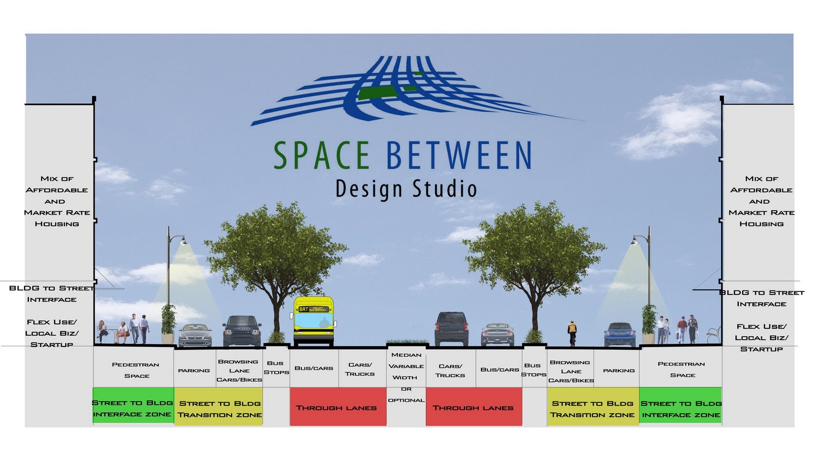
In the heat of the discussion of whether 175 should go transition from a dangerous highway that severed local connections to a 6-lane boulevard or a 4-lane boulevard, I decided to propose a compromise where the 5th and 6th lanes would be shared bike/car browsing lanes and at lower speeds than the 4-primary travel lanes, thus creating a calmer interface between LINK and PLACE:


Click graphic to mega-size

One of the key issues in planning these days is making sure buildings interface with the sidewalks, with permeable buildings made possible often through ground floor uses that are open to the street that are typically retail or small office, have plenty of clear glass to accentuate the visual permeability, and multiple entries along the building wall.

What we have still been very bad about is ensuring that street designs do the same, that they also interface with private development sites. Our arterials are the perfect spot for this kind of redesign, 1) because they are already very wide and 2) density of development WANTS to align with density of movement. However, this doesn't happen because our arterials are not designed in a way to promote density, to interact with the kind of mixed-use development that makes for great cities (and generates the most tax base).

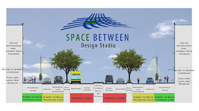
European cities have been much better about doing this than we have. The above section is modeled after a typical European boulevard. You'll see the traffic with the highest rate of speed is towards the center and away from more vulnerable forms of movement such as bikes and pedestrians. The highest speed lane is the middle most, where the lane next to it incorporates a bus lane to be shared with traffic. Because the buses frequently stop, it is closer to the transition zone, which is then shown in yellow. The yellow zone is for medium speed to slow speed traffic (15- to 25-mph) and includes parallel parking as well as a shared travel lane between cars and bikes. Lastly, is the green zone, which is the pedestrian realm, for the slowest, most vulnerable of movement, but also where there is the most interaction between street space and access to private uses.

The one glaring Con with this scheme is the width of the Right-of-way. It doesn't recapture a great deal of land that can then be used to leverage private investment whereas the 4-lane scheme does. However, this scheme DOES create a better interface between traffic flow and potential development along it than would the 4-lane scheme.

[edit 2] Just checked out the highway section and it looks like the ROW is about 210' give or take. The street section above is 130' give or take which would leave 40' in depth on both sides to roll into potential private development.

Other little details: the new street could probably use a new name (edit: nevermind - just noticed that the Cesar Chavez renaming extends all the way to the curve) and the graphic doesn't include lighting in the center median. I think there is also a good opportunity to make this central street lighting a sculptural, iconic element for a great street that makes an emphatic statement for the City and South Dallas.

[edit 3] If you've been reading this blog for any period of time, you know that I like to draw analogies from various biological sciences to explain various elements of the urban puzzle and occasionally apply the principles to urban design. In many ways, the new section dictated by speed and comprehensively looking at all forms of traffic including bikes, pedestrians, buses, driving to park, and parking, operates in many ways like a stream section where the fastest flow is to the center:

Velocity in a straight river

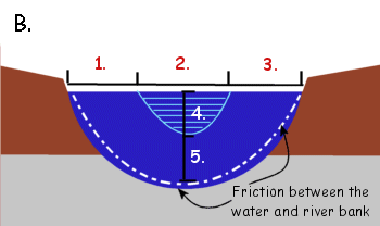
The fastest flow in this stream section is in the area labeled 4. The slowest is in five, but depth doesn't really apply, unless you want to show a street section with a subway running below it, I suppose. As many fishermen can probably tell you, the areas just below the surface towards the bank, are the areas with highest degree of biodiversity. This is where life happens, where water eddies, gathers, spins, and dances along the banks and there is some interaction between bank soil and water, people and buildings.

Dead man's Curve

This is almost good news all around. DMN has the story of money intended for the completely unnecessary Trinity Toll Road to be shifted to de-highwaying 175 through South Dallas. Well, if we need to spend money on roads, might as well be to downgrade them rather than new capacity. As with many roads, new infrastructure (in this case 175) was thought to be the necessary investment for bringing jobs and investment to certain areas. When it is the wrong kind of infrastructure, the kind that severs community ties, local economies, and hinders real estate, that is hardly the formula for new investment.

Except apparently we can't get it all right. It looks like the arbitrary traffic formulas will win out and the road will be 6 lanes instead of the 4 that it should be.
"Traffic volumes and conformity dictate the need for six lanes versus four lanes," agency spokeswoman Cynthia White said. "The City of Dallas supports six lanes."
Conformity with what? TxDOT now has Context-Sensitive Design Manual. Dallas now has Complete Street Initiative in place. Why not conform to those? Actually leverage real investment in the part of town that needs it. After speaking with people involved with the bike plan, while doing field work, they reported that South Dallas is littered with 6-lane arterials that get maybe 5,000 cars a day. The formulas are above reproach.

Now if we wanted to make it 4 travel and 2 cycle tracks, to build expanding the burgeoning bike culture in Oak Cliff to South Dallas, than we'd be getting somewhere. If it goes to 6, I predict within ten years we end up taking it down to 4.

http://1.bp.blogspot.com/_D5kx0bUGx_c/S9ihpD3a8FI/AAAAAAAACUU/Wbop-nUdI-w/s1600/175.jpg