Showing posts with label Metroplex. Show all posts

Tuesday, March 13, 2012

The Urbanology Show

We've finally gone and done it. Kevin Buchanon of FortWorthology and I have started a podcast. The first episode is here and as Kevin describes it:
Episode 1′s topics include: designing streets for people vs. designing them for traffic movement, a brief introduction to Fort Worth’s Near Southside revitalization district, how the Internet and social media is affecting urban revitalization, the polycentric nature of cities, lack of transportation choice, building lighting, demand-driven urbanism vs. supply-driven urbanism, Deconstructivism, the revitalization of Bilbao, Woody Allen, the Enlightenment, and inappropriate Winston Churchill quotes.
Kevin has podcasted before so for me I suppose it was about getting the hang of it. We had been getting together about once a month over beers to talk about the very same things so we decided to start recording and putting those convos on blast, y'all. Though we both tangent trip by nature, the wide variety of topics listed above was surely caffeine induced, as the show was recorded at Avoca Coffee in the Near Southside area of Fort Worth. Next time, it will be over beers, meaning it may be more jovial and/or sanguine.

Tuesday, February 7, 2012

DMN's Sprawl Series, Part 1

I'm going to use this space to respond to various aspects of the series the Dallas Morning News is running on sprawl. I don't know exactly where it will lead since I haven't yet read parts 2 or 3, but after reading part 1, there were so many inaccuracies and lazy assumptions that rebuttal is necessary.

Note: All of this is behind the DMN's paywall. I will not do a full fisking, which would require cross-posting the entirety of their content. So I will limit what I post to the most critical strikes and gutters.

And to be frank, I'm having other people feed me this content since the DMN doesn't seem to have an itunes inspired pay per column idea and I can't convince the capitalist in me to spend above and beyond what I perceive to be the value of the content. This series does nothing to dissuade that opinion.

Apologies beforehand if anything herein hurts anybody's feelings, but I care about two things: the city I live in and the profession I work in. So yes, I get angry. Without proper understanding of the issues and dynamics at hand, both of those two things are badly weakened.

If the DMN wishes, I will replace quotations with paraphrases, but some information and debate needs to be in the public realm.

My words in a nice claret red.

---------------------

At current growth rates, the North Texas suburbs will reach the Red River someday.

I see their going for rhetorical bombast in their lede. It won't. One, you can't make the same mistake economists make far too often. Trendlines don't extend to infinity. Only timelines do. Cities are inherently restricted by transportation technology and the time humans are willing to spend making the connections necessary in their daily lives. This is why cities throughout history are an hour wide (and here I'm referring to cities in the sense that they are the physical manifestation of interconnected local economies, ie the amorphous, contiguous body you see in satellite imagery). So unless teleportation technology is invented or the planet's carrying capacity somehow manages to increase exponentially this will not happen. And as for the assumption that the internet is like teleportation technology allowing us to further disperse, I counter that here. The internet facilitates and caters to clustering moreso than it does dispersal.

Cheap land, good schools and other strengths have fueled an era of suburban development in North Texas, spurring unprecedented job growth, prosperity and a high quality of life.

Incorrect, lazy conventional wisdom. As I joked this morning on twitter, it is amazing it took civilization to find the valhalla of great schools that existed out in the wilderness for millennia. Had we only discovered them earlier, it would be unicorns for all. Yes, schools draw famillies. But, first the families drew the schools out there and provided the tax base for them. Similarly, the young, engaged families that moved into North Oak Cliff over the past five years have transformed the local elementary school.

Furthermore, land was/is cheap outside the city because it was not viable for anything but agriculture or wilderness. It was only when transportation technology and infrastructure was created that repositioned this land as viable for improvement. The highways also downgraded the value of all the land near them. They linked disparate places but disconnect local ones. The math on that is that one connection was made, but dozens upon dozens were lost. Sum degree of integration diminishes and therefore accommodation (built uses) also diminish. Look at any overvalued highway frontage property and its inevitable life cycle from office building or hotel or whatever until its death rattle as a gas station or triple X shop.

The drawback of course is that much of this was cannibalistic and merely growth for growth's sake. How many people moved specifically because of that growth boom and the various related industries? And without that, we go the way of the rust belt. Ultimately cities are about desirability and opportunity. The opportunity is instilled by network interconnectivity. The driving force of the suburban "growth" will be the demise of both the brief blip of growth which cannot exist without purpose, opportunity, or a magical solution to cheaply transport us from place to place.

"Other strengths." Like what? Name them. Here seems like a good place to point out the difference between sprawl and a legitimate suburb that is attached to a "host city" but is not parasitic, like Torrent, Spain outside of Valencia. It is also more family-oriented, but also provides a range of market-oriented housing types and built-in mobility, as provided through proximity and legitimate transportation choice. There are also jobs, a quarantined but nearby industrial sector (really the only use (Locally Undesirable Land Uses or LULUs) that ought to be "zoned", a legitimate downtown, connected to Valencia by rail, and local food production/agriculture immediately abutting development providing stability and food security while we have about 3 days worth of food at any one time.

Imagine if there are significant disruptions to global food supply and shipping? Imagine how expensive food will become as fuel costs rise. The only way cities survive, let alone grow, is if they are adaptable and durable. Sprawling sun belt cities provide neither.

The pro-growth culture is so strong that planners foresee a day when development reaches out 100 miles from Dallas. Yet given the long-term costs behind such a layout, some community leaders believe that unchecked growth is unsustainable.

These "planners" are smoking something, lest they be wholly incompetent. This idea is so deliriously malinformed, I can't take it seriously, but have to because it threatens to discredit my profession. Me. Infastructure of sprawl is badly failing because by its very nature decentralizes, reducing tax base while increasing tax burden. This does not, nor will it ever add up, particularly in a world of increasing pressure on finite resources. But go on thinking forever growth is possible. Whatever sell you want to make to keep bringing in federal transportation dollars for massive projects providing the seeds of our own destruction.

Yes, Detroit can happen here. It is like we are following Lewis Mumford's playbook toward Necropolis to a T. Perhaps our industry is more diversified, but is housing?! Is transportation?! Detroit, at root, died because we ran out of a need for cars as hundreds of thousands sit idle at ports, both foreign and domestic. So what happens to a city built for cars and cars alone?

It is critical that we distinguish quantitative growth from qualitative. We can still "grow" the economy without expanding, nay, fracturing the fragile bonds of the economy. In fact, the ONLY way we can grow is to grow back inward and recluster. And no, that can't be coerced via Urban Growth Boundaries. That should be dismissed out of hand as politically unfeasible. Nor is it particularly desirable. However, we can build in nudges to make infill more desirable. We have to. Because right now, all policies (be those taxing, zoning, transportation planning, funding, and design) steer us to sprawl. To forever growth. And since forever growth is a contradiction in terms, toward our own demise.

Commute times are rising. Air quality has declined. Water supplies are strained. And as subdivisions continue to sprout up on the Texas prairie, older communities closer to downtown Dallas have struggled to turn around aging neighborhoods and declining school enrollments and replace outmoded infrastructure.

First portion is all true. As for the second part, SOME central areas have struggled. On the other hand, I give you uptown Dallas, which added $2 billion with a B in tax base and investment. I give you North Oak Cliff, where the cool kids hang out. And then there are countless other places like Deep Ellum, Greenville, Knox-Henderson, etc etc. which are trying against all odds (infrastructural burden and isolation) to come back. The deck is stacked against them. Sprawl is NOT the market's choice, but the inevitability of badly misguided policies intended to provide relief from the dystopia wrought by industrialization that continue to this day (despite there no longer being much industrialization to speak of).

The Dallas-Fort Worth area has more people, about 6.5 million, than all of Texas did during World War II. More than half of that total now live beyond the city limits of Dallas and Fort Worth.

Aside: I just deleted several graphs of DMN content. Did the DMN focus group (verb) that people will only read one staccato-like one sentence machine-gun paragraphs? My senses are dulled by the onslaught of textual MTV.

And the region is slated to almost double in population between 2000 and 2030, according to the North Central Texas Council of Governments. Most of that growth has been on the edges. The region now measures roughly three times the size of Rhode Island.

We'll see if that growth ever occurs. And is that desirable? Do we want to be like Mumbasa? I'm not against population growth in DFW, but who would willingly want to jump into a city at McDonald's and WalMart wages to pay off the debt of our own infrastructural burden? "We can't afford to live like we've been. Move here!"

Collin County, the nation’s fastest-growing from 2000 to 2007, is the epicenter. The county’s population has tripled in size since 1990 and is now comparable to that of San Francisco or Detroit. Frisco’s population, which was a mere 6,000 in 1990, stands at about 120,000.

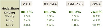
Weird juxtaposition. Intentional? If so, I'm impressed by the subtlety if it exists. By 2030, where will Collin County be? Where will San Fran? Where will Detroit. Three separate places with three different dynamics. Only one of which currently appeals to the human need, facilitating social and economic exchange with minimal "movement tax" of time, distance, and infrastructure. San Francisco has 66 neighborhood commercial centers where 5,000-7,000 people live within a quarter-mile, walking distance. San Francisco removed a highway (albeit a damaged one in the Loma Prieta earthquake). San Francisco has some of the most valuable real estate in the world. And as long as we're talking about market forces, price = demand = desirability, much of which stems from opportunity inherent within a legitimately networked city.

The search for good schools, cheaper housing, more space and easy road access has driven the migration. The consolidation of smaller suburban school districts after World War II helped propel the surge.

Horsesh!t. All of it. "Cheaper housing." Nothing is more expensive than cheap. The resale value of said houses at the edge are plummeting, fast approaching zero as we realize there is an inherent locational cost factor previously ignored in housing. Something called, "transportation." It only seems cheap on first blush. Economics are so much easier when you can ignore externalities too. Damn the torpedoes.

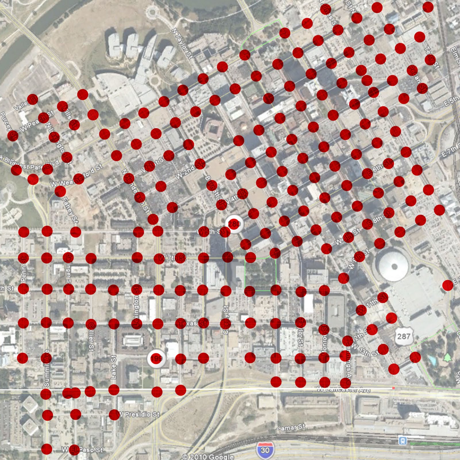
Prices have begun correcting around the country for the imaginary influx of capital injected into the housing market, inflating the bubble. That is one part of it. Many places around the globe suffered through this housing bubble. But many also built internally, providing quality construction that can be passed on through generations, retaining value. We built bird nests out of sticks and spit that will blow away with the next stiff breeze of reality and changing generational preferences. The second part of the price correction yet to be fully felt is the locational one.

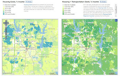
Hot Damn! Look how expensive housing gets when you factor in transportation. If you can't see or enlarge this graphic, darkest green is over 60% of pre-tax household income. Meaning after taxes, housing costs, and transportation, many people have nothing left to save or invest. Sweet system we're setting up. We couldn't sack this city any better if Attila were in charge.

Sherie Hammett, a mother of three who lives in a large Plano home, is one of many North Texans attracted to cozy suburbia for those reasons.

She said she sometimes drives up to 100 miles a day running errands. She keeps clean clothes and a small refrigerator stocked with water in the back of her Chevy Suburban.

“It’s the quality of life,” Hammett said. “It’s the safety of knowing your kids can be out front. You get a little bit of everything up here: The schools are good, you can get the space and still have money for others things.”

Lulz. This is the bit where we convince ourselves we love our captor. Nobody ever self-diagnoses Stockholm Syndrome. Extra money to spend on things like driving 100 miles per day. Life cycle of a highway section is only a few decades. This wasn't a down payment, but layaway. Bills are coming due.

Here is also a good point to show the data that sprawl is the least healthy, least safe place to live, particularly for kids. Diabetes and obesity are directly linked to sprawl. Oh, and the leading cause of death for teenagers? Car crashes. So if this woman is driving 100 miles per day, should we call Child Protective Services? (rhetorical)

We're rational people and Ms. Hammett made a rational decision, because it is better than the alternative, anything near the cities. Our policies don't allow us to build safe, desirable, attractive, walkable urban neighborhoods, which would proliferate if given half the chance.

Yet perhaps more than any other factor, the rise of big job centers amplified the pace and scale of development here.

Derp. Jobs follow housing, employment bases. People create demand

“He had the resources to do whatever it was he wanted to do,” said Robinson, who is now 72 and lives in Plano. “To build a city from scratch was just an incredible opportunity. It was just cow fields at the time.”

Little did Robinson and his boss think Legacy might jump-start an entirely new ring of suburbs. Combined, Legacy and Richardson’s nearby telecommunications corridor have almost as much office space as nine Empire State Buildings and are home to about 100,000 workers.

The corporate office campuses are failing badly. They needed a walkable core, hence Legacy Town Center. Not many places can pull off a Legacy Town Center. Not many places/people have the resources, land, will, and foresight to pull it off. Legacy Town Center will remain, much like Torrent, Spain exists. Everything around it has a far more uncertain future. Other sprawling municipalities will find the going much more difficult to recluster and will have to think differently while learning from Legacy's lessons both good and bad, while acknowledging they likely won't 1) have an EDS at its height nor 2) the 90's and 00's building/housing climate.

A commute from a subdivision in Prosper to downtown Dallas takes about 45 minutes without traffic. The drive from Prosper to Frisco is about 10 minutes.

If my aunt was my uncle she'd be my uncle. "Without Traffic." Let that one simmer a bit.

The funny thing about so many modernist policies is they establish some impossible ideal and frame that as reality. Free markets also function perfectly when no people are involved. Communism too. Pick your -ism.

These "corridors" funnel people toward certain roads thereby inducing traffic. There is very little route choice. Furthermore, since the hideously inhumane roads we build are sociofugal, meaning they decentralize and disperse us, meaning more and more Vehicle Miles Travelled for everybody. More cost for individuals, more infrastructure costs for cities, more taxes (eventually) on all of us. Have a nice day!

These are facts and they are indisputable. As proven by two recent studies. One by a Brown U. economist which showed every intra-city highway led to 18% population reduction (dispersal). And another showed that with every doubling of per capita lane miles, VMTs increased on a related 1:1 proportion. Double lane miles (with the intent of reducing traffic), people just end up driving more and further. And the bigger roads just fill up again with induced traffic. Mission: FAILED.

Dallas and Fort Worth have some of the highest lane-miles per capita in the country, trailing just Kansas City. This is badly misguided government spending at its worst. You'd think at a time like now, we'd choose pragmatism over profligacy.

The fundamental flaw in modernist road planning, building, and design is that it works best, optimally, when only one user is on the road. Everybody and everything else is an obstacle. This is why you (okay, I) get so subconciously angry whilst driving. Everyone else is the enemy. Someone to be bested.

Now, let's think about the real purpose of roads, of networks. And that is to facilitate social and economic exchange generating as much positive return on our investment as possible, with minimal "taxes" like congestion, delays, operations and maintenance of vehicles, etc etc.

If these roads work best when no one is on them, they are failing economically. When they are crowded, they cause traffic delays, congestions, wrecks, etc. and are failing socially.

Because property tax revenue is the lifeblood of local communities, cities are desperate to raise new cash through development. It is often the only option, as many Texas voters are averse to tax-rate increases.

Good thing our policies reduce tax base while increasing tax burden so your tax dollars go less and less far (snark). Walkability is a tax cut, people.

“Anyone who supports an increase in taxes is not a very good person and should not be re-elected,” jokedMichael Morris, transportation director for the Council of Governments. “So cities have to get their revenue from more development. … It’s hard for them to turn down any type of development.”

So let's plan, design, and fund transportation networks that ensure that development's life cycle will be as short as possible (snark). Integrated networks create opportunity, drive demand, ensure long-term utility and durability of an area, which manifests itself in development. Upward growth and maximization of land rather than outward growth.

Plano’s tax base has leveled off in recent years. So leaders have funneled millions in grants and tax abatements annually to encourage businesses to relocate, expand or just stay put. Collin County commissioners last year talked about granting tax breaks to almost every new business that opens its doors, an unprecedented measure. The county eventually settled on a scaled-down abatement.

You reap what you sow. Like there will always be another strip center, new and further down the road to cannibalize, there will always be another city willing to bet the farm on smokestack chasing. Meanwhile, other cities are experiencing an influx of talent and entrepreneurs, starting businesses, meeting demand, seizing opportunity, merely because they WANT to be somewhere. This lasts. Appealing to emotion is durable. Appealing to wallets is temporary. Necropolis.

“Texas has always been a very strong property rights and pro-growth state,” said Dave Gattis, historian for the Texas chapter of the American Planning Association. “It’s growth at any cost.”

The mindset of cancer cells.

Texas zoning laws have seen few changes since the 1920s, when a landmark U.S. Supreme Court case, Euclid vs. Ambler, laid the foundations for modern zoning practices.

Cut n pasted responses to industrialization.

Since then, most Texas cities have adopted rules that guide everything from setbacks and landscaping to the number of parking spaces required. Many also have drafted informal long-term visions for their communities.

Arbitrary, pointless, and often destructive themselves.

In many ways, the loose regulations complement this state’s long-standing culture of self-rule. Since the days of Sam Houston, Texas landowners have built as they have seen fit.

Which is why there was no sprawl until many of the restrictive policies and regulations were enacted, thus creating a singular homogenous product of sprawl. If the DMN is suggesting Texas libertarianism is the cause of sprawl, they couldn't be more off-base, ignorant, and misleading. Shameful.

The flip side is the perpetuation of a system that, from top to bottom, not only enables sprawl but encourages it.

“If there were no regulations at all, then people would be moving as far away as possible — assuming they could get public services,” said Gattis, who also serves as deputy city manager for Benbrook, a Fort Worth suburb. “There would be no protection of open space, no density. It would all be sprawl.”

See my last statement, this is wrong. 100% incorrect. Otherwise, they would be living in Montana or Alaska. Social and economic exchange, meeting our needs and wants is only possible around other people.

“You used to be able to tell the difference between McKinney, Allen, Plano, Richardson, Dallas. There was cropland between each one,” she said. “It’s all covered up in concrete now.”

And we're still running with the premise that this is market forces, that this is desirable, DMN? Hmmm? If you beat it into my head one more time I might start to believe it.

-------------------------------------------------------

Parts 2 and 3 to follow later this week as time permits.


Friday, December 10, 2010

Your Daily Dissent

Decided to bump this to its own post. A reader dissents to a previous on streetcars:

Reader from Austin M1EK:
I'm one of those naysayers - and the problem is these are being sold as mobility improvements rather than amenities for urban development. We've backed down our plan here in Austin to almost as stupid as Fort Worth's now, because relatively few people are willing to be honest about the fact that a streetcar running in a shared lane is actually even worse than a bus if you care about speed and reliability.

But yeah, if you're a tourist, or have gone voluntarily car-free, a streetcar might be nice. How about if the developers pay for it then, and not just the initial capital cost - but bond out the operating cost as well? In the meantime, transportation funds should go to things that can actually shift mode choice - like light rail.

My response:

legitimate points.

Let me raise others that many don't often think about.

First, I want to mention something I heard last night, that the McKinney Avenue Trolley is up to 300,000 riders per year. And if you've ridden it recently during peak or rush hours, you understand. It is literally packed. Far more so than when I rode it to/from work every day living in uptown 2004-06.

The significance of this suggests a mode share change by the typically younger demographic that lives in uptown, millennials.

Secondly, as we begin to price parking more appropriately, people will be looking for outlets that don't require paying 100/month in parking downtown.

Light rail has an appropriate service length as do modern streetcars. Streetcars can better serve the neighborhoods within 1 to 3 miles with very frequent stops that light rail can provide only 1 or 2 stops at best. These immediately downtown adjacent areas are where the greatest gap between existing and potential lies, aka profit, opportunity, value, and of course, interesting walkable urban neighborhoods.

Lastly, and perhaps most out of the box, is the idea of mobility, shared lanes and traffic calming. The MATA trolley often makes driving on McKinney Avenue a pain in the ass. And that is a good thing. It is harder to speed, thereby making walking along McKinney and crossing it, much safer and more enjoyable (despite the narrowness of sidewalks).

It may hurt long distance mobility, but it increases localized mobility and the interconnection or "tethering" of neighborhoods.

Wednesday, December 8, 2010

Blast from the Past, On Streetcars

With Fort Worth literally lighting money on fire to the west (I can see the smoke signals from my new high-rise window), preferring to live in and defend their medieval castle (Stop the Trinity Plan! Oh no, it means competition!), I thought I would dig up this old comment I made on FortWorthology from back when Kevin was still optimistic and hadn't yet locked himself in a fetal position in the basement:

(it is responding to a naysayer supporting buses over streetcar)

Empiricism suggests otherwise once all of the auxiliary, correlated, and causal effects are effectively weighed which are either too inconvenient or too complicated for the anti-streetcar crowd. Fortunately, if this is what their final stand has come down to, streetcar vs. buses, then we (and our cities/economies) are in good shape for the future.

First, streetcars being on fixed alignments provide greater predictability for the real estate development market to properly associate price/value potential of a site given its proximity to the line. It instills a hierarchy, an awareness for what works rather than trial and error urbanism. While real estate development is guided by an “invisible hand,” that hand is always tied to an invisible arm, that being government and public investment. Do we want a smart, efficient, guided real estate delivery system or a dumb one that stumbles around the edges trying to either create real estate value from scratch or hoodwink people? See the housing bubble.

History has proven streetcars to be a far more effective tool in catalyzing development (particularly the high quality urban development the Mayor has stressed) whereas buses and their “greater mobility” aka greater inefficiency effectively doom themselves by their own inefficiency and sparse building patterns.

Second, modern streetcars are more accessible for the disabled, handicapped, elderly with the flat loading and along with their increased predictability for real estate the public awareness of the line is greater. The simplicity of alignments allows the linkage of important place to important place not only physically but in the collective consciousness of the community. They know where to catch it and where it will take them. So if people can’t get on a bus or don’t know where to catch it or how many transfers they have to take, all deter from the mobility you are claiming that comes from some antiquated or outright false theology.

Third, buses must be replaced every 3 to 5 years and are a maintenance nightmare due to their construction and internal combustion engines whereas Dallas and other cities have streetcars running that are a century old.

Lastly, and perhaps most importantly, the modern streetcars are slick, sleek, and represent progress. Much of the engine of the private market place is psychological and often irrational, driven by consumer/investor confidence. Initiating that confidence in the 21st century sustainable city, with positive symbols of which all cities who have them are inherently proud, is one of those steps to pulling a recessionary economy out of the doldrums.

Lastly, buses will still be part of the equation, but as circulators for the less dense areas of cities at the edges linking with other rungs of the hierarchy such as DART, TRE, AND streetcar. There has to be a multiplicity of solutions, an ecology of sustainable modes of transportation including more walkable/bikable development with associated improved public infrastructure. The effective load of buses will be lessened. Streetcars will serve and drive the physical form of areas 1 to 3 miles from the primary hub or job center being downtowns.

The empirical history of city evolution is the best lesson and will provide a far better guidebook than the misguided theology of the 20th century that so misguided us such as the theory of mobility (much of which was driven by the car/oil/gas industries successfully seeking monopolies) but rather real mobility through actual and differentiated choice, fundamental to any real marketplace of which the City is the ultimate one.

Thursday, July 29, 2010

Bring on the Streetcar

No progress ever occurred without having to overcome the skeptics.

Via FortWorthology, there is a great OpEd at the Star-Telegram in favor of, well accepting the Federal money for a streetcar. Duh.

To many, before this discussion started, a return of the streetcar sounded more like a tourism gimmick than a game-changing modern transit system. Two years into the discussion, however, most of us actively working to revitalize our central city would never call the proposed modern streetcar a gimmick. We have seen how the competitive advantages of walkable, transit-oriented urbanism have returned and how modern streetcar systems are transforming central cities into sustainable economic engines.

Companies are locating along modern streetcar lines, and developers are building thousands of housing units along existing city streets instead of along new and expensive roads at the edge of town. Highly skilled workers with choices are shopping for cities that offer a full range of transportation options.

Fort Worth needs to enhance its appeal to new businesses and residents. We can't ignore the negative effects of sprawl-related problems -- congestion, unhealthy air and far too many generic developments that aren't sustaining their value. Those issues have deep roots and won't go away soon, making it clear that we must promote a vibrant, distinctive and prosperous central city to stay competitive with our peers and that we must act quickly.

Let's recap. In both Dallas and Fort Worth, we have several "neighborhoods" ripe for reinvestment. They were originally created by streetcar as outward pressure and a new technology "unlocked" the value of the land a mile or a few outside of the City Center. For a variety of reasons, the lines failed, mostly through a lack of density.

Skeptics of streetcars generally fall into two-camps: those that have their interests against such things as freedom of mobility, ie controlling interests in a monopoly of transportation and those that hide behind some religion of "free market" willfully ignoring that no transportation in this country is designed or created by the "free market." This represents a letting go of the reigns of inertia that will ultimately grind our cities into some failed state while praying to that same religion to guide us into a happy afterlife of rainbows and unicorns. Fortunately, we have the power to steer that inertia towards a positive outcome, albeit not easily.

Cities need residential density. Streetcar needs density. These downtown-adjacent neighborhoods are the perfect spot, less burdened by the more intense activity of downtown business districts, while being close enough to those centers of gravity to walk, bike, or say streetcar to the amenities therein,

In order to deliver supply to match the demand for urban housing, these areas need transportation alternatives. Otherwise, the development will be engineered by and respond to car-oriented design. Meaning roads will be too overscaled and unwalkable. Parking facilities will be too big and therefore too expensive. And it all becomes a barrier to investment and you end up with a drive-thru McDonald's, which might generate 1/20th of the tax base. More potential residents move to a mind-numbing garden apartment in [insert suburb here so as to not offend one] built of sticks and paper and will last about twenty years before it becomes a slum and is then razed. Thumbs up.

Somewhat changing subjects...

There is a medium-sized town somewhere in this country I once suggested should look into unearthing their buried streetcar tracks as one component of a downtown revitalization plan. Shot down, too expensive. Of course it was. But, we're also talking about 30- or 50-year visions and available federal match. Another key strategy I proposed was to recapture excessive right-of-way in overly-scaled one-way streets through downtown.

The idea was two-fold. First, to calm traffic and "road diet" (verb) the streets so that they were more context-sensitive to a downtown location, and second, to roll that land into private development projects as an incentive to (re)develop into more intense, walkable and mixed uses and get some much needed residential back downtown. I've been seeing that idea pop up more and more across the country these days now that more budgets have burst.

Now? Streetcar porn:


Friday, July 23, 2010

What to Post When I Have Only 5 Minutes...

First, Dallas first got snubbed by the college football hall of fame, now ESPN chooses Fort Worth for their Super Bowl week staging despite all branding of the game/week will be "Super Bowl in Dallas!"
We could have made any site in Dallas work. There was just a lot more convenience in Fort Worth -- the convenience of hotels, of having six or seven different restaurants to choose form every day. I know Dallas has all of that and more, but it all being in such a condensed area was a big deal for us.
I don't particularly blame them. Every time I am in downtown Fort Worth, the contrast in scale and feel of the streets and blocks in comparison with Dallas is rather striking (even though in Fort Worth it is for only a handful of blocks). It simply feels better, while the analytical side will say it is due to the size of the blocks, the way the buildings interface with the sidewalks and streets, the height of those buildings, etc. The only part of Downtown Dallas that really could have worked for all of their needs would be Pegasus Plaza and it is too small. They outright rejected Main Street Garden, City Hall Plaza, and the Arts District because they would feel lonely.

How does Thierry Henry celebrate his first MLS game? By riding the train to work.
"I was on the train with my friends, with all the fans. It was quite an experience. It was the quickest way to come, so that's how I came. It was cool."

Thursday, July 8, 2010

Toot Toot!

http://cincystreetcar.files.wordpress.com/2009/01/modern-european-streetcar.jpg

It looks like Fort Worth is one of the big winners for more hot stinky federal cash money for new transit lines. From the FTA announcement website:

Project: Fort Worth Streetcar Loop (Urban Circulator)
Sponsor: The City of Fort Worth and the Fort Worth Transportation Authority
Amount: $24,990,000

The City of Fort Worth and the Fort Worth Transportation Authority will construct a 2.5-mile one-way streetcar loop with between 20 and 25 stops and three vehicles to connect a Trinity Railway Express commuter rail station and Intermodal Transportation Center with the central business district. This will be the hub of a planned streetcar network connecting six designated “urban villages” targeted for redevelopment to the city’s major employment centers, such as downtown and the Near Southside Medical District. Ultimately, the streetcar system will connect residents in four economically disadvantaged areas to job opportunities in major employment centers, while stimulating the redevelopment of walkable urban neighborhoods with a variety of housing choices.

Dallas also gets a hand in the pocket to extend the MATA to St. Paul DART station and loop back on Olive:

Project: Olive/St. Paul Street Loop (Urban Circulator)
Sponsor: Dallas Area Rapid Transit Authority (DART)
Amount: $4,900,000

The Dallas Area Rapid Transit Authority (DART) will build a 0.65-mile urban streetcar track extension to an existing system. This project would link the current McKinney Trolley to the existing DART light rail St. Paul Station and to the McKinney Trolley Olive Street Extension in the heart of Downtown Dallas. The connection to the Olive Street extension would form an entire reversing loop for the trolley, making operations safer and more efficient, while connecting downtown destinations such as the Dallas Museum of Art and the Nasher Sculpture Center to Uptown Dallas.

That is about it for Texas projects except for some chump change to Brownsville. Just kidding. Brownsville is probably doing backflips over a $4 million grant for intermodal station. But the question is, what the heck are Austin and Houston up to???

Tuesday, June 15, 2010

Fort Worth Intersection Density Analysis

Recently, I began elaborating off the recent walkability studies suggesting that the number 1 indicator of safety and walkability is intersection density. However, as I put forth in the original post, I felt there was something more to learn by expanding this study. The simple point was not all intersections are created equal and a hierarchy must be applied. Furthermore, it applied the concept of convergence, which by nature uses urban form to instill hierarchy to the real estate market.

With the understanding that the grid (of whatever form) provides the neural network of urban economies, the end result, I believe, is one that merges walkability and hierarchy of urban spaces in order to identify problem areas of the City. It is also fun to play with, tweaking various streets and blocks, two-way conversions from one-ways, and seeing the potential transformative effects those changes can have on real estate potential.

The following is downtown Fort Worth run through the same analysis as Dallas and Portland (and I will be doing more downtowns and like this one, hopefully tweaking and advancing the metrics and capabilities of the analysis).

For the understanding and assumptions, please see this link. Where I amend some for the purposes of this study, I will detail those in this post.
------------------------------------
As you see below, in relation to downtown Dallas and many other similar cities, Fort Worth has very small blocks. The Fort Worth blocks at approximately 225' x 225' actually are more reminiscent of Portland, which would lead one to expect that Fort Worth would approach the Portland result for intersection density per square mile.


RESULTS:
Downtown Dallas: 186 intersections per square mile
Downtown Portland: 356 intersections per square mile
Downtown Fort Worth: 208 intersections per square mile

The result is actually barely above what Dallas achieved. Like Dallas, downtown Fort Worth exists on an island, surrounded on four sides by essentially man-made anti-urban devices fraying the urban grid as it departs the central core of downtown. For a comparison to how this relates to walkability and transportation modal share, find this link or see the below graphic (numbers across the top represent intersections per square mile):


Fort Worth is very disconnected from its surrounding fabrics, often with a singular connection to the adjacent neighborhoods. This is revealed as the density of dots or intersections breaks down outside of the Main Street core.

Having personally walked the downtowns of all of the above towns, the rankings of the three downtowns in terms of walkability matches my own sense. Downtown Fort Worth is very walkable, but only in the core between the convention center and the Tarrant County Courthouse.

In relation, Portland also has a much bigger downtown area uninterrupted by disconnective agents. Portland also has done a better job dealing with freeways, which are sunken with the urban grid extending across, maintaining walkability for a more consistent and broader area.

Similar to Fort Worth, Portland also has a river and waterfront forming an edge, however Portland, having removed a freeway have done a better job of breaking down the edge by creating a more publicly accessible riverfront park.

When applying the point system based on intersection convergence we get the following breakdown by intersection:


With a mile square aerial of downtown at 200 px, I applied a similar graphic scale by point system to each intersection as follows:

1 - 20 px
2 - 40 px
3 - 80 px
4 - 160 px

The resulting graphic:


RESULTS:
Downtown Dallas: 391 intersection points per square mile
Downtown Portland: 746 intersection points per square mile
Downtown Fort Worth: 455 intersection points per square mile

The first thing that I wanted to examine was the ratio between intersections per mile and weighted intersections per mile. Dallas and Portland came out to .476 and .477 respectively, or remarkably similar. Fort Worth's ratio is .457, somewhat below, but still amazingly close. My guess is this slight reduction might be due to the high number of T-intersections in downtown Fort Worth (which I admittedly may underweight).

Conclusions:
The most obvious conclusion is that I'm overweighting four-way intersections. I pointed out this probability in the last study, but it had not yet been so dramatic. The biggest splotches of red in the above graphic represent four-way intersections with the intent that the most people are moving past these intersections. Except in Fort Worth these are almost without exception limited to the various peninsulas of development radiating from the downtown core, mostly the intersections of minor streets. It is obvious there needs to be some definition between types of streets forming those intersections.

As I pointed was probably necessary, downtown Fort Worth gets the first Meta-Convergence analysis. To do so, I highlighted all of the roads that connect beyond the district, the primary linkages between the downtown area and the adjacent neighborhoods. Where a four-way intersection got four points for the four directions people approached the intersection in the basic convergence analysis, for the Meta-Convergence I give a bonus point for every direction that arrives on a primary "stem." So a four-way intersection between two primary links could achieve up to 8 points rather than the four as previous.

To maintain 160px as the maximum I rearranged the pixels per intersection so as to not overlap on nearby intersections by the following point system:

1 = 20 px
2 = 40 px
3 = 60 px
4 = 80 px
5 = 100 px
6 = 120 px
8 = 160 px


While there are still some outliers, this starts to make more sense. Since I reduced all of the dot sized by points, this graphic can not be directly compared to the above simple convergence graphics, but only to examine within its context, certain parts of the downtown or intersections to other intersections.

One thing this reveals, is the off-center nature of downtown Fort Worth on its "island" and the potential for downtown to expand to the West.

In general, the Meta-Convergence analysis is best at showing opportunity areas where the density and real estate values are underperforming. Most often this is due to the vary roads creating the traffic. The design of the roads are strictly for cars and the buildings and people then withdraw from that road. This is "inside-out" urbanism.


When we add in a graphic for "under-performing" or underdeveloped sites we predictably see that most of the underdeveloped sites have a direct relationship with the locations of the car-oriented street framework.

The question then becomes, are these properties really underperforming? In my opinion, the answer is that the surface parking (or parking garages) are a direct market response to a terrible, unsustainable transportation design and network. Parking is the highest and best use, but not a great (or walkable) downtown does it make.

So while there is great potential in where red and yellow overlap, the responsibility lies on the public-side to overhaul the primary roads to something that can move more traffic in a people- and place-friendly manner.

Complete streets are 1) centripetal, in that they draw people to them rather than centrifugal streets which are repellent, 2) can move more traffic by moving less cars (meaning increased modal share via more efficient transportation modes), and most importantly 3) link to the vastly underdeveloped areas immediately adjacent to downtown.

These are the neighborhoods within the 1 to 3 mile radius of downtown where bikes and streetcars make the most sense and will leverage increased development.

This study reveals that the most potential lies along Henderson and W. 7th for both downtown expansion and inner-ring (outside of downtown) development. But the primary barrier to this potential is the overly wide, pedestrian unfriendly design of the both streets.

A couple of questions remain:

Does the new Meta-Convergence properly weight intersections?

My guess is no, leading to some outliers of four-way intersections on streets that may see less than 100 cars per day.

Have we factored in various other "magnetic" forces such as parks?

Not yet. I also haven't begun applying subjective "punishment" of certain intersections or roads for being particularly egregious. There are also local factors such as Fort Worth's bizarre tendency to build parking garages or other buildings over streets. I'm sure this seemed like a good idea at the time, but I also haven't figured out how to properly demerit a street or intersection for this.

Other issues to expand on:

There needs to be another level of analysis that where intersections of a certain density begin to multiply off each other, perhaps there are bonus points for uninterrupted grids. This is why the downtown core of Fort Worth is a bit undervalue here, in my opinion. But objectively, I still feel the base Meta-Convergence graphic can stand on its own, particularly in how it suggests the potential of downtown to expand Westward.

Next time, I also hope to apply the "bonded" study which examines the segments between intersections for how permissible crossing of the various streets are. There would have to be a healthy dose of subjective professional judgment applied to this in cities where I'm not terribly familiar with the specific dynamics of a street based on personal experience and examination.

Thursday, May 13, 2010

Hot or Not: Instructions

After seeking some council with all of you residing on the other side of this computer screen, I think the best way to go about this is to provide a simple 1 to 10 rating system where each of you can vote on each individual neighborhood or development around the metroplex. My hope is that this can give us a baseline for assessing the rights and wrongs of a place in comparison or contrast to various other places within the Metroplex. (I will probably occasionally include various ones throughout the country that might be similar to something we have here, i.e. LA Live vs. Victory)

After enough voting occurs, I will chime back in with what I believe was done right and wrong and what lessons we can all learn from the place for future reference.

What TO DO:
Rate the pictures of the place based on experience. How does the place make you feel within it. We want to take Apples and Oranges and find some commonality in a standardized scoring system. For example, if it is a great single family neighborhood it should rate highly.

We want to gauge the subjective. We want to measure the emotive capacity of a space. What I will do is run the neighborhood through the objective criteria established by LEED-ND for what a neighborhood in order to show (or not) the limited ability of the objective. My hope is that two places might rate equally high on LEED-ND, but have a huge disparity in a place's ability to emote, which is probably far more important and telling.

What NOT TO DO:
If you once lived there and had a problem with the landlord or your neighbor either abstain or try to put it out of your mind. If you have had architectural training, I'd like for you to try to turn that off as much as possible and focus on the quality and experience of the places between buildings. The places where cities are experienced and remembered.

I will try to incorporate a number of photographs to provide the full experience of the place. Try to look at the place through the eye's of a scientist, as if you are looking at what is under your nose for the very first time.

I've got a busy sched today, but I'll try to get the first one up as soon as I am able.

Friday, April 30, 2010

Announcement: May 21st

[DSC01465.JPG]
Actually, I think of it more as a solution. Thank you very much.

If you haven't been to our friends at FortWorthology, head over there some time. If you haven't been to Fort Worth, have we got something in store for you.

As many of you may know, on most Fridays, we organize a local happy hour preferrably in local, walkable neighborhoods throughout Dallas. It is also often orchestrated with a free beer from me to the first person who guesses the City shown in various imagery and hints of the City's history, origins, demographics, morphology, yadda yadda.

Well, on May 21st, we will be having a dual happy hour with the good people of FortWorthology, set in where else but in the siamese sister city of Fort Worth! Omigod that's so far away. How is that walkable? Glad you asked. We will be taking the TRE out there.

Next question: Why so far away? Well, that answer is two-fold. First, Kevin of FortWorthology has the crazy idea that he wants to train around the country for three weeks to see the land and visit the great cities sprung from its soil. Second, we want some time for people to plan, since it isn't exactly about walking from the office to the corner pub.

Kevin also has some ideas for location and we will be working out further details including potential cross-site competition for the Free Beer Guess the City. Perhaps two cities, two potential beers??? Yum. I just might have to guess in his site's competition.

Tuesday, April 20, 2010

A Clockwork Orange Line

Something to accompany your steaky-wakes and eggy-weggs this morning:

http://entertainment.ie/images_content/ClockworkPic.jpg
Eye-opening ideas.

With funding problems a plenty for not just the orange line, but virtually all planned transit lines the DMN Transpo blog has an excellent idea up from the awesomely Texan-named Garl Boyd Latham.

What we are learning is that we actually can't have our steaky-wakes AND eggy-weggs AND eath them too all at the same time despite knowing full well that transit capacity and hierarchy of service is necessary for the city's and region's long-term viability. The world is no longer made of funny money...and this is a good thing. Funny money makes for incredibly (and sometimes indelibly) stupid and short-sighted city planning. It gives us time to pause...and prioritize. What is most important?

Latham's idea is to finish the Orange Line to the airport and I agree with him that connecting downtown to the airport(s) should be a priority, representing a carfree link to the global economy. If your city doesn't have that, good luck in the competition of cities of the 21st century.

One issue with the Orange Line as currently planned is that once complete, it will create a logjam of trains on the existing downtown line along with the Red, Blue, and Green all converging along the same corridor of limited capacity and inherent (in)efficiency to move them all through the City. Hence the reason for D2. The thought was that D2 would run through the southern portion of downtown, alleviate pressure on the current line and leverage private investment in the neglected areas of town.

Sounds pretty good right. Of course, there are also financial realities. One D2 alignment costs approximately $300 million. That's the cheapest. The City's preferred alignment, to the new "bricks and mortar" project, the convention center hotel, costs approximately $600 million (jaw ->floor).

Oooooooh-Kay. Time to rethink. Rather than run a second line through downtown, Latham suggests running the Orange line directly to Union Station, eschewing the train traffic snarl on the current line.

A direct link from airport to Union Station immediately increases Union Station's significance within the city. Currently, it is an afterthought. If that becomes the single place for businessmen (and women) to catch their ride to the airport, it once again becomes a hub of activity. Furthermore, it is only two blocks from the Convention Center Hotel and provides the opportunity to leverage the value of land around Belo into functional urban fabric.

His other idea is to effectively replace D2 with streetcar. I like this idea for several reasons:
  • Streetcar is cheaper than DART lines which are much closer to heavy rail than they are light rail. Streetcar can cost around $20mil/mile where DART lines could be anywhere from $80mil/mile or in downtown or subway type conditions upwards of $200mill/mile.
  • Streetcars run on the street and help to calm traffic making downtown roads more walkable, which is necessary for urban investment and development.
  • DART hasn't shown the ability to leverage much in the way of retail activity. My guess is the reasons are two-fold: it serves a much larger area meaning that, like highways, it serves macro-destination to macro-destination: 'burb to job center (downtown) whereas streetcar is much more fine-grained. Second, it hasn't shown the ability to "mingle" with cars and pedestrians alike the way streetcar can.
  • The geometries of a heavier rail like DART make it difficult to turn and corner within the confines of downtown urban fabric. We end up with more spaghetti under in and around the freeway spaghetti which act as barriers, further disconnecting downtown from its foundations, the neighborhoods adjacent.
  • Streetcar is best at leveraging investment in areas immediately adjacent to downtowns, which I'm slowly but surely leaning to the opinion that Downtown is so constrained that if you don't remove the freeways, you have to build up the value around downtown in order to make downtown viable.
  • Because streetcar is more pedestrian friendly AND cheaper, it generates more bang for the buck by way of private investment, which means...
...take whatever money is alotted for D2 and:

1) Run streetcar from Union Station to Oak Cliff as is currently planned.

2) Run streetcar from Union Station down Canton/Young into Deep Ellum.

3) Do NOT move MATA off of St. Paul and extend it past Main Street Gardens to intersect with the new Canton/Young line with plans to eventually run it to the Cedars.


Everything is linked into Union Station, and if we ever plan on having High Speed Rail, Union becomes a true multi-modal facility serving the various necessary hierarchies of transportation in order to properly link downtown with the local, metropolitan, regional, state, national, and international economies and returning "pride of place" back to Union Station as downtown Dallas's front door to the world.

Thumbs up.

Friday, April 16, 2010

Ode to Texas Stadium, Was Road to Texas Stadium

Greg Lindsay at Fast Company profiles the demise of Texas Stadium and the City of Irving's desire to replace it with TOD. If you follow either of us on twitter, you might have seen the 140-character interaction we had on the subject last Friday.

I worked on the initial "dreaming" scenarios some time ago (linked here where the only remnants are the little watercolor icons to the right of the page), before the recent computer-generated renderings were produced. I'll admit. I didn't know what I was doing back then as a young whipper snapper. Because of my early involvement though, I felt the need to be as impartial and objective (and unfortunately non-colorful) as possible with my responses.

The salient 'graphs from his piece, which is quite good (except that I wouldn't say downtown Dallas is the most walkable in the region, but rather uptown Dallas):
Before a single plot of land was sold, he ordered the dredging of lakes and canals, stocked them with gondolas, and ran a monorail overhead. "It is Disney World for the affluent," Texas Monthly reported in the 1980s. "In fact, when executives from Disney World visited the development a few years ago, one of them commented that it was a shame ol’ Walt couldn’t have lived to see the real thing." Las Colinas is what you get when you let CEOs and their site selection committees design a city. (ed: Have truer words ever hit the interwebs?)

What’s most interesting about Irving’s plans to added density in its last undeveloped corner is the tacit admission that Las Colinas’s gold-plated office parks and single-family homes are no longer enough. "The piece that has always been missing from Las Colinas is the human density that’s missing on weekends and at nights," says Gast. The reason for adding that piece is an eminently practical one -- it’s what those corporate tenants, their workers and developers all want. Irving is embracing transit-oriented development because it thinks it can make money doing it.

And therein lies the complications...Not helping is the possibility of major funding cutbacks at DART, including the possibility the Orange line won’t run all the way to the airport anytime soon. And the final bit of potentially wishful thinking is the notion that a stadium site at the convergence of three freeways - the so-called “Diamond Interchange” - can ever be converted into a Millennium Park, especially when TxDOT is leasing the site for 10 years to carry out freeway expansion.

I'll leave that for you dear reader. Have a great weekend all.

Friday, April 9, 2010

What Did I Just Say

I wasn't exactly going out on a limb or exploring any new ground outside of logic and common sense, but today the DMN has an article on NCTCOG's own explorations into private funds in support of the Cottonbelt line. The basics:
With transportation funds running short at every level, regional planners for the North Central Texas Council of Governments are seeking permission to lead an unusual partnership with private investors so they can fast-track a 62-mile rail line known as the Cotton Belt corridor...

As with toll road deals, private partners who invest in rail lines would insist that every service decision - from ticket costs, to station locations, to schedules and parking fees - be examined with an eye on how much revenue they could produce.
This is what I said just a few days ago:
Now the real brain damage can start: how to pay for the construction of something that, like all transportation, rarely pays for itself, has high initial startup costs, and a return that is disconnected from its investment. Because it does generate returns for landowners near to lines, increased tax base for cities, development opportunities for private investment, and eventually increased mobility due to the associated high density development that accompanies new streetcar lines, we are confident that it will take creative public-private partnerships to see the vision through.
Here is where it gets sticky. The investors would be looking at conventional revenue generation, i.e. fares and fees to generate their return. I suppose that could work, but in a world where all transportation is essentially a sunk cost in the name of commerce and interconnectivity (and in this case increased land value), that could raise fares to a rate that might be a barrier to utilization, driving down ridership, and in turn, rate/date of return on investment. That, or the public agencies must dig really deep to pay back investors first and take all operations at a heavy loss. The structure of this deal can work in that those with the most long-term benefit, the cities/public agencies, are essentially taking a loan from private investors in order to raise enough upfront capital to build the line.

Perhaps, we should look back at the history of rail (heavy rail and streetcars) in order to locate private investors. Rail and streetcars were originally funded by landowners with the most to gain, speculators looking to unlock the potential of their newly acquired property for residents seeking to escape the squalor and poverty of 19th and early 20th century industrial cities. Other investors were new industries created outside of cities. They wanted to either deliver workers to the job site or in the case of company towns, deliver their mined material back to cities.

It was an exploratory phase, not unlike the motivations and mechanisms propelling the latest exploratory phase, as we know as, sprawl. On the timeline of city evolution, which is longer and therefore slower than most humans can comprehend, it is our way of testing out the real value of land. For example, we are finding that some areas of sprawl will still have value and will see reinvestment in the form of increased density and walkability, while others fade back to nature or agricultural production, etc.

Like then, those that have the most to gain from investing in new transit lines within the amorphous post-modern city are (possibly but not definitely in order of magnitude):
  1. the landowners in an around the stations where their potential value would be increased (increment to be determined),
  2. businesses nearby to stations who would benefit from employees/customers within walking distances,
  3. the prior two combined with the potential decrease in parking demand thus allowing for reduced parking land area, parking fees, and infill opportunities,
  4. the transit agency (obvious stake in the game) who could build a parking facility with revenue generation to support transit station and reduce the amount of surface parking mentioned previously. Remember: parking should rarely if ever be free,
  5. cities. more long-term benefit through reduced traffic capacity, improved intracity connectivity, more dense development, and increased tax base.
  6. the riders. Obviously, they will be paying the fares. Unless we were able to get to a free fare system due to enough investors above that see the value in the above and can guarantee their returns indirectly by way of something other than fares.