Showing posts with label World Class Cities. Show all posts

Wednesday, January 25, 2012

Why Are Skylines Roughly Conical?

I want to take a graphic look at some concepts I've been developing lately, in conjunction of course with the work it builds upon, including the Bartlett School at the University College of London and their work on mathematical models of spatial integration as well as the Andres and Douglas Duany codeveloped concept of the transect.

Spatial integration began as a scientific examination searching for objective realities to urbanism. Why were cities and their patterns so similar? Where and when have we begun to go wrong? And is the aesthetic, subjective driven world of Modernist architecture partially to blame?

Completely independent of this work, the Duany brothers saw similarities in the gradient of intensification of cities as you got closer to the core with various ecologies, particularly coastal regions:


This, became this:


Both relied, perhaps intuitively on the concept of centrality, which has its origins in the study of social networks. Since cities are the physical platform for social and economic exchange, empowering the links between them, network studies had direct relevance. Cities are networks.
But the Transect never really digs into why what was where. Sure there is a dense node at the center, with an decreasing gradient the further you get away from it. But what created centers in the first place? That is where space syntax began examining infrastructural networks. Professor Bill Hillier and his pupils/colleagues found a correlation between social network analysis and infrastructural networks. That is, social hubs have the most connections. The highest degree of integration. Likewise, this parallels with the internet. The highest trafficked sites are hubs that all others link to. Think Google. From there exists a hierarchy from most to least.

Likewise, cities have a similar hierarchy. The most connected places, have the highest degree of integration, which in turn means the highest degree of opportunity. Where there exists the greatest demand, to which the market responds with supply. Building space. Where demand is greater than supply exists the most opportunity for developers. Where integration is highest is the most opportunity for every citizen to meet their needs for social and economic exchange.

This concept exists locally, within one city, as well as globally, amongst all cities. New York, London, Tokyo, Paris, etc., are global cities because they are the most connected, both locally and globally. Within a single city, you also have a hierarchy of centers. All cities are polycentric once they get above the scale of the tiniest of hamlets. This is what sprawl apologist hacks like Joel Kotkin fail to understand. When they talk of polycentric, sprawl-based cities as polycentric cities of the future, they fail to see that New York is also polycentric. Those centers just blur together rather seamlessly, except where geographic barriers (water bodies) or physical barriers (such as highways) divide and isolate them.

Space Syntax map of London:

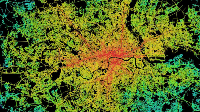
What they found was that there is a correlation between traffic and value. Just like with any network, particularly the web. The most trafficked sites have the most value. Remember that traffic doesn't mean cars, but people. This is a direct relationship in what I call logical cities. High pedestrian areas have far more people moving past, and capable of interacting with you (economically or socially) in these high traffic areas than does car-based traffic, which has to turn, wait for lights, find parking, etc., all of which accounts for increasing degrees of disconnection, dislocation, and inflexibility.

In the logical city, such as the London-based map above, there is another chicken/egg based component to it as with all complex, interconnected systems. The infrastructure funnels traffic to specific places and specific places also "bend" the infrastructure to them. This is why I call them centers of gravity, what many planner types call "nodes". They literally shape the city around them. Increasing their level of interconnectivity, raising demand, and eventually via opportunity, supply.

Because of the chicken/egg scenario, this also means that infrastructure can create places out of thin air, such as when two railroads meet in the midwest. The traffic intersection becomes an opportunity. And many cities are here today because of such a phenomenon. I'll look at that a little more later.

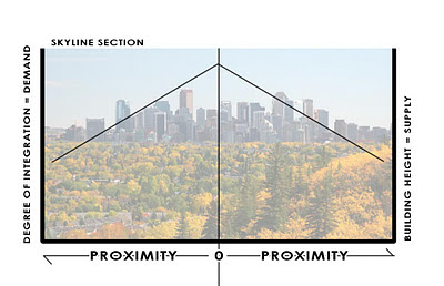
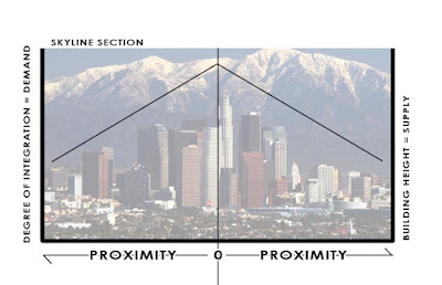
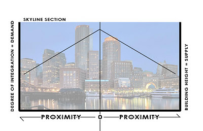
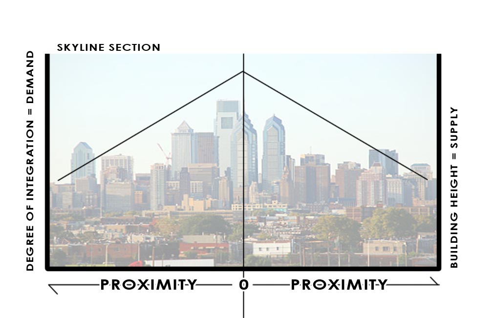
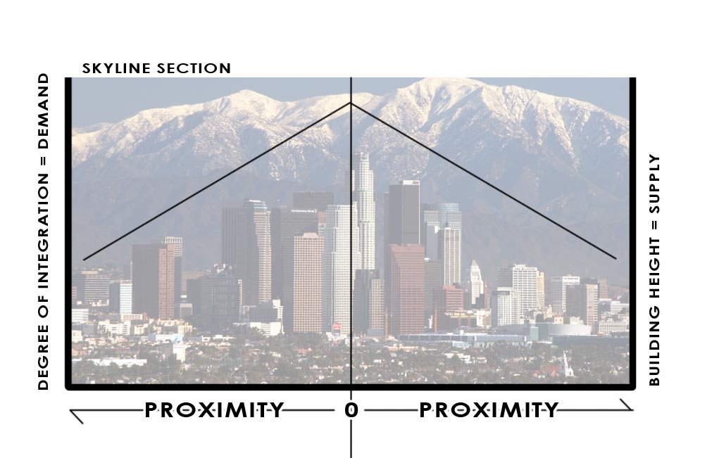
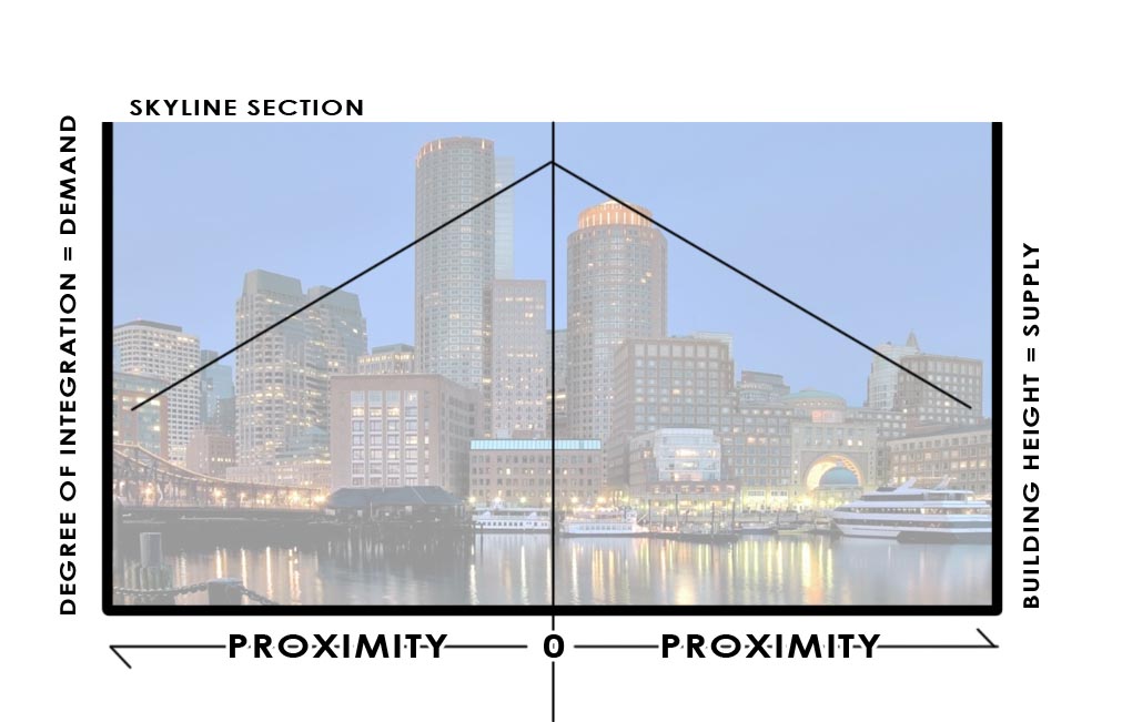
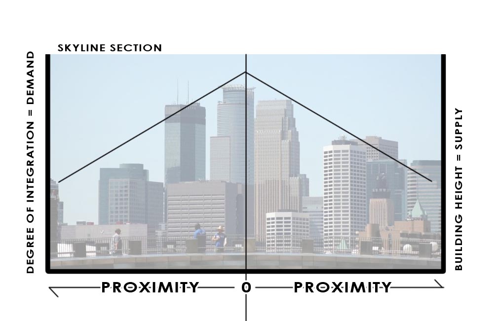
But first, here are several skylines:
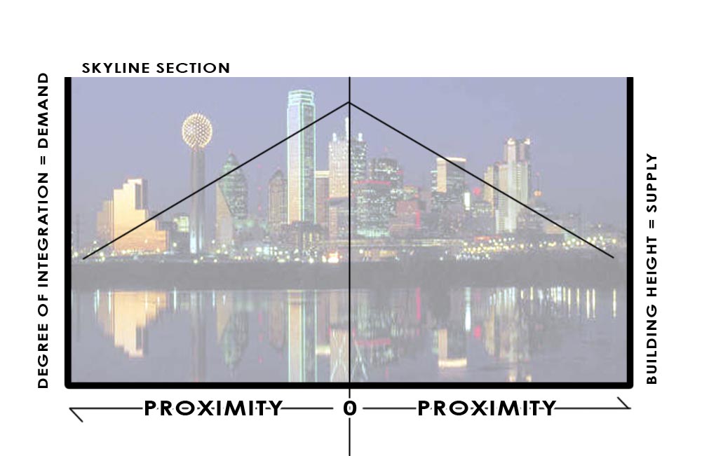
While this is Dallas and the exercise is admittedly abstract, I want to show why downtowns have the biggest buildings. And why severing the interconnectivity to them, is why many of Dallas's buildings in downtown are quite empty, for example. As I have written before, Dallas experienced a building boom (high-rises) at the exact same time that the city, state, and federal level were gorging on highway building. Supply was being added while demand was being undercut, shipped out towards the suburbs.

Those polycenters, instead of being closely interconnected, became Las Colinas and the various highway adjacent corporate office parks around the metroplex. That they were newer or the space is better and they are "grade A" office is irrelevant. The newer development would be in and around more walkable, more highly integrated and interconnected places (more authentic places). They would also prove to be more resilient. I expect, unless they drastically reposition themselves, many of these office parks will fade into dust. With new light rail (another degree of interconnection) and residential, Las Colinas is already doing that.

Compare our growth to say, L'Eixample neighborhoods in Barcelona and Valencia. These were rapidly expanding areas, literally doubling city size, but they did so aggregately. These are both now considered the "old money" areas of those particular cities, and very much still central city as growth then enveloped them.


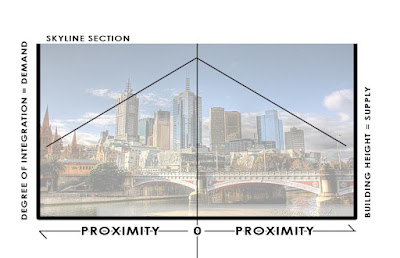
The dynamic changes a bit for cities like Paris or Washington, D.C. Both cities with extremely high levels of integration, locally and globally. Remember, that local integration is the foundation from which density and resilience lie upon. The most connections can be made locally in dense, walkable environments.
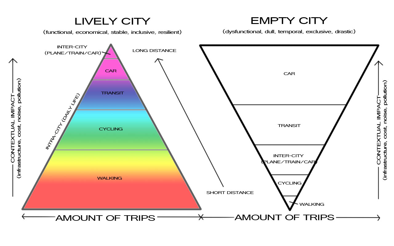
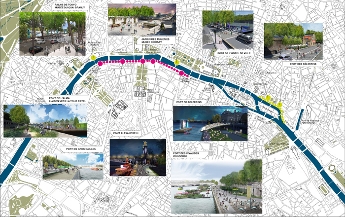
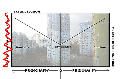
Because the level of integration is so, demand is extremely high to be in the center of Paris (or D.C.). But height restrictions limit the amount of supply of usable building space, making prices skyrocket. The center of Paris is amazing. Who doesn't love it? But it also leads to this condition where opportunity then shifts outward, toward the Banlieus, or suburbs:
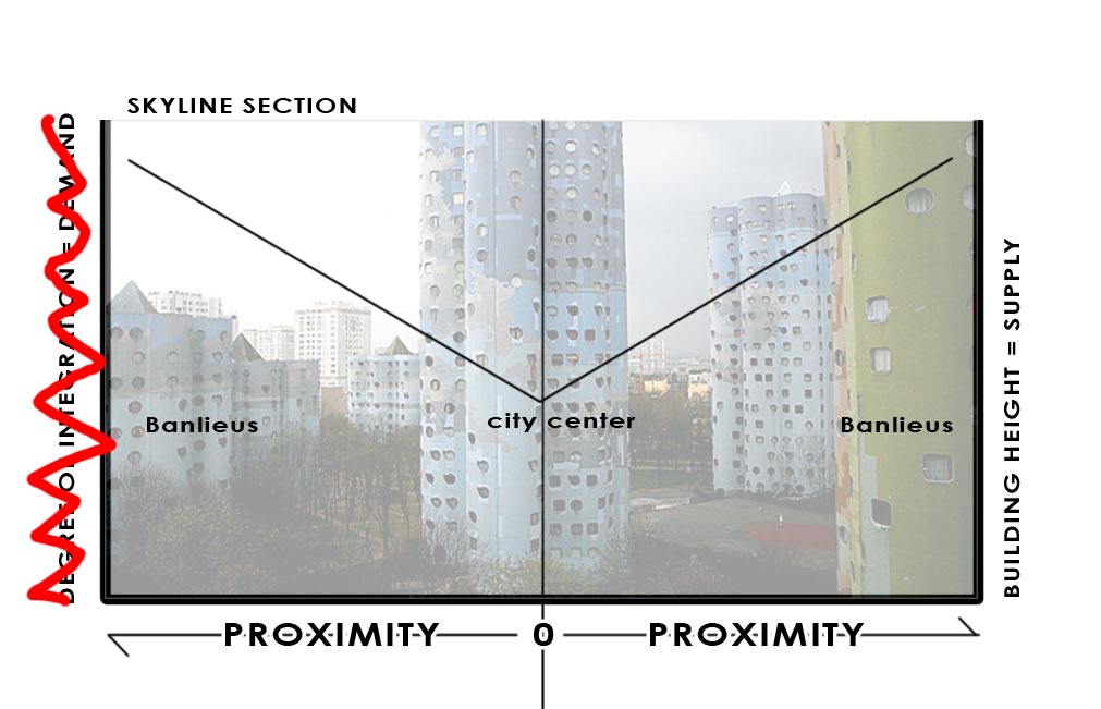
The supply is much greater than the demand, which is to be actually in Paris where opportunity is high. But it the market can't meet the demand, so it spills outward. Too much supply, with too low levels of integration. There isn't a natural, organic match. This is made even worse with the design of the "towers in the park" housing for the poor. Whether they were built for the poor or not, eventually they were doomed to devolve because of supply being much greater than the demand. These types of Corbusien buildings are physically isolating, cul-de-sacs in the sky. In effect, the supply is borrowed from the areas with higher integration, higher value. Not coincidentally, these are the areas where Paris experiences the most civil unrest, in homogenous areas of poverty exemplified by socio-economic isolation. Isolation. As in not integrated.

However, this is not to say whether Paris or DC's restriction on building height is wrong. That is a political debate. In my estimation, these cities heights or lackthereof is precisely what makes them so special. 1) The building heights remain humane, lower to the street level, and more interactive. And perhaps more importantly, 2) the demand pressure exerted upon a limited supply ensures that the limited space will always, ALWAYS be maximized. And buildings will be preserved rather than destroyed.

The real issue is improving the connectivity, integration, and walkability within and to the suburbs. Here is where I shift in language from banlieus to suburbs because the need is universal. American suburbs may not have many, if any, high-rises, but supply is currently way above demand, as defined by spatial integration values. Values are plummeting across the country, not only because of the evaporation of liquidity (real or imagined), but also a general market realization and price correction towards this supply/demand imbalance.

There is a movement afoot to "retrofit suburbs." While there is certainly opportunity to do this, and a necessity in many cases. I'm afraid that while some areas will be fine, some will need salvaging, while others are fairly doomed. We simply won't have the capability of retrofitting ALL of them. And by retrofitting, I mean increasing their local connectivity/integration quotient to instill, increase the demand to catalyze the new infill that the retrofitters propose. There will be extreme levels of competition and upheaval, I expect, in American suburbs.

As for city growth:

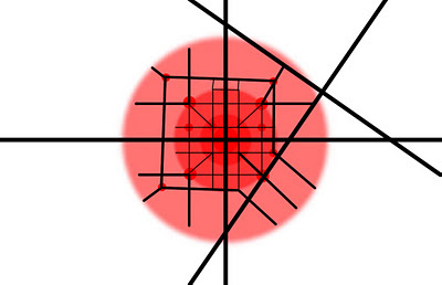
As I mentioned earlier, it all starts with an intersection. This could be anything:

Two railroads crossing
Two ancient trade routes
Fertile soil and a deep water port

The connection globally has to be strong enough to maintain the raison d'etre. The local connections, like walkability, ensure that the place is efficient and livable. And that people like living there as opposed to the competitors. It is also important to note that no cities current place within the hierarchy is the place it will reside in 10-, 20-, 50-, or 1000-years. Such is the competition amongst cities. And such is the need to maximize local and global connectivity, as well as the raison d'etre for that city, whether it be energy production, idea production, or a socially vibrant place. Whatever it is, it better be timeless. See: Detroit, autos. West Texas, exhausted oil wells. Heterogeny ensures timelessness. Or something approaching it.

Here is the intersection. Imagine it is any of the aforementioned. The red implies the neighborhood development.


If the raison d'etre is strong enough, its opportunity level persists. It attracts more people. The city expands, aggregates:


Eventually, maybe it grows to the point where it needs more global connections. And as technology advances, the infrastructure is needed for those global connections, such as an airport and an interstate. However, all global movement is destructive to fragile local interconnections. Highways and airports can have negative effects upon overall interconnectivity despite increasing global connectivity. Local connectivity drops, therefore demand drops, therefore desirability and opportunity drop and eventually people will leave that city. That is why these global infrastructural networks must be treated very carefully, connecting with cities tangentially.

Vancouver didn't allow freeways into their city. Paris is removing all of them inside the peripherique. They're connected to their airports via subway. Subways are built because at-grade and above grade tracks are disconnective. Below grade is supremely expensive, but as all cities who have them have found, worth the high initial cost to preserve the fabric above.


And within those overall connections, smaller nodes or centers of gravity will emerge at the various convergence points. That is, only in the logical city. In the illogical city, where connections are disruptive and diminish overall connectivity and the ability of its citizens to meet their social and economic needs for exchange, a tension is created. The tension is two countervailing forces. That towards traffic, ie traffic = value. And the opposite force is the repulsive nature of those global connections, ie highways and airports.


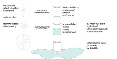
You may have to click on the below image to expand it. It's one I've been working on to explain this concept. At the top left we have attractive nature of convergence. People create infrastructure to create opportunities for social and economic exchange, meeting points, trading places, markets. When you disrupt that network, you shift the magnetism so to speak, like putting two like poles of magnets next two each other.


When you look to the right diagram, the glass is supply of building form. The demand is liquid. When you interrupt local connectivity and overall integration (often for the sake of global connectivity), you are essentially creating a hole in the glass. All of the demand spills outward. You get sprawl and an empty glass. Like downtown Dallas highrises.

Wednesday, June 2, 2010

Thought Provoking Density and Dallas' Schizophrenia

This blog has certainly spent its fair share of time discussing density, however it has never had the primacy for me that it does with other planning-type blogs. I've always felt it to be a bit of a fools gold and that design of cities is more important. While density of interactions, aka propinquity or proximity of all things needed for the daily exchange routine that occurs, is important for the efficiency of cities, in my opinion density can either be good or bad. If density is merely a way to warehouse people with little other concern, particularly to how the building relates to the rest of the city then it is deleterious to the city fabric. At its best, it should be merely a response to desirability. Demand-based rather than supply-based.

I thought this article at The Midwesterner was particularly thought-provoking for how it may relate to Dallas-Fort Worth and its identity. The basis of the article is the basic question of whether density was a good thing. The final thesis arrived at was that for global cities, those that compete as world class exporting centers of cultural foment, density is absolutely critical. This makes sense in the Creative Cities, Density of the Educated discussion. Smart people interacting in a participatory manner with each other energizes the creative process.

However, the flip side is that more regionally based cities are precisely that way because the lack of density is desirable for those that live there. The Urbanophile misguidedly alleges this is due to the nature of being able to drive anywhere in the the particular town in fifteen minutes. So those in cities of lower wages should be more dependent on potentially volatile gas prices and spend a greater percentage of their income, ie greater tax burden on making their daily connections?

In my estimation, this probably has more to do with Zipf's Law and a more natural cultural and personal predilection to various population densities (and the local and cultural amenities inherent) than anything as mundane or prosaic as "they like driving and the ease at which they do so." As the Midwesterner and Bruce Katz point out, they probably just haven't yet realized the price of expanding outward faster than population growth can support (particularly in rust belt cities).

As far as Dallas is concerned this raises a question that I can't answer. Dallas likes to see itself as a global city errr "world class," perhaps masking its own insecurities with false bravado. But, there also seems to be a perception (and one that I enjoy as well), of Dallas being a collection of smaller towns, loosely interconnected. Of course, the less dense, loosely connected does not a global or world class city make, but it is very much the perfect embodiment of the modern polycentric of satellite city form.

Are the two even as mutually exclusive as they seem?

My guess is that indeed density is necessary for the cauldron of creativity bubbling over in World Class Cities (and the draw that creates in importing talented people), but not necessary at all for livable places.

So which is it Dallas, which do you want to be? A global player or a looked down upon wild west podunk town on steroids? Do we want to compete with OKC and Austin (which are rapidly urbanizing themselves, catching up?) or NYC, London, Vancouver, Paris, Hong Kong, et al?

Of course, if we focus strictly on livability, we could be competing with Zurich and Copenhagen, which wouldn't be a bad thing at all.

Wednesday, April 21, 2010

The Dallas Dynamic and Why Holding it Up to Vancouver Matters

[Warning: Prepare yourself for a long-A squiggle squiggle post.]

Recently, I received an email that could generally be described as somewhere between angst-ridden and soaked to saturation in rage-a-hol. The general gist expressed a feeling of helplessness while the City of Dallas, one in which the person obviously loved and had a passion for, was being torn asunder for more endless seas of paving, parking lots, and overly engineered contrivances.

The following was my best effort to rationally and analytically (with a great deal of insider knowledge) weave the tale of the City by the stinky-apparently flood of ark-necessitating proportions river. Afterwards, a few other nationally and internationally recognized colleagues/experts chipped in with a telling contrast between Vancouver and Dallas, which will follow my posted email.

But before you run off on the "omigod we're not Vancouver you hippy commie" reactionary tangent, let me explain the relevance within the comparison.

People are people. And because our underlying needs and desires, the way we are wired, are the same no matter where we are, city form and the processes therein function similarly. Because individuals are different, the way we flavor our cities is driven by the unique identity of the various individuals. Urbanity is the platform for expression. Urbanity is science, expression is art. In the science of cities, yes you can compare various places.

Recently, as you may know Vancouver hosted the Olympics. Dallas has on occasion chased the dream of one day hosting the Olympics as well. My recollection is that they never curried enough favor with the USOC to be considered a viable candidate to win over its grandaddy, the IOC.

Dallas also likes to talk in terms of "World Class Cities." We get all self-congratulatory when hypocritical hacks like Kotkin and Brueggman tell us we are the paragon. I don't think it would be a stretch of the imagination to say that one relatively objective status indicator as "World Class City" is membership in the prestigious club of having hosted an Olympic Games. There have certainly been more Olympics held than there are World Class Cities in the world (how else do you think Atlanta got them - oh, right...bribery and corruption), but taking a look at some of the distinguished cities on the list, it is obviously a good start (just recent and future sites):
Rio, London, Athens, Vancouver, Sydney, Beijing, Turin, Athens, Barcelona...
/once lived in Atlanta. Left.

I believe in honesty. Science and understanding require it. Improvement requires understanding. It also requires deep affection. I love the City of Dallas and all of its eccentricities and eccentric individuals. I too want it to be a world class city, but you can't get there without first being honest with yourself. Just like you can't achieve self-actualization without deep, honest introspection. The emotion is there. The direction is not.

So in the vein of achieving "World Class" thru introspection and understanding (edited to make appropriate for the blogosphere):
I think the palpable rage expressed here represents the way many (most?) Dallasites feel about the multitude of projects happening around the City. The citizenry feels misled at best and disobeyed at worst. The funny thing about Dallas is that there are many people/groups in positions of power (of various forms), but at the same time nobody is in charge. Very few get along or have been marshaled into a singular direction or vision. Filling the void is the standard operating procedure, which comes in the form of road widening and highway expansion under the guise of "road improvements" or alleviating congestion or "economic development." All of which provide temporary relief, but long-term create more problems than when they were started.

Because the rabble is starting to wise up to the way they are treated as a third world country in need of vast infrastructural projects (many of which are unnecessary and bankrupt the city of the long-term), they become further cloaked under a new "guise," public parks and green space. Who could say no to parks right?

Well, eventually Dallas citizens realized that the park was simply another way to appease the masses in order to build another highway, which not so ironically would further disconnect the City from the River improvements. Slowly but surely under intense local pressure the "parkway" was removed from the Oak Cliff side of the channel to only the Dallas side. Step 1 in the right direction. Pressure endured.

Now, a new project emerged which is the widening of Industrial Blvd and renaming to Riverfront Blvd. I had a long convo with somebody directing one of the design processes yesterday who felt the "improved" Industrial might signal a fall back plan and that under the increased and growing scrutiny the Trinity Toll Road is DOA. Of course, Industrial-turned-Riverfront is still a widening project under a guise of "complete street" and laughably gets compared to Champs Elysees...without being the Main Street for a global Capital and the cultural totems of an entire nation, unless of course if you count Lew Sterrett Jail (read into that what you will).

In sum, all of the projects: Pegasus, Woodall Rogers Deck Park, multiple Calatrava bridges, the Arts District, are all projects that, fall under misguided attempts at economic development. Sure, they might generate some, but in the long-term, I believe many to be overstated in their effect. For example, the Deck Park has the nearly fully built out Arts District on one-side and LoMac to the north side. What is left? Perhaps the improvement of one more block to the north side, which will engage McKinney Ave before the park anyway. That would be maybe a $60 million project leveraged by a $60 million park.

The "connectivity" people suggest it will add is overstated as well, as one of the three connecting roads between uptown/downtown has been removed.
Removing all of these local, "grid" connections in favor of the overly hierarchical dendritic pattern is a mistake, cutting off the neural network of local economies in favor of a system where any traffic jam acts as a stroke is no way to build a city, which is simply the physical representation of a local economy.

Furthermore, because Dallas is bounded by other municipalities, unlike Houston which annexed all of its growth, the highways act as the lifeline for the suburbs to leach the life from Dallas, who gets stuck with the carnage and the bill.


For those who don't know, LoMac (Lower McKinney) is a lot of density and very little urbanity. It was driven by the recent housing boom and the residential towers are insular and have little to no relation to a very bad street network, which is the foundation of all of the problems. The street design and transportation framework that is guided by increasing capacity and flow creates roads that go through places but never to places. The result is that any and all development is hurt by the countervailing pressures to be both near traffic but away from it.

The funny thing is that so many of the recent projects at the large scale: Victory and Park Lane Place, or the individual buildings such as the Ritz Carlton in LoMac will not reach their full potential/value for some time as they were designed to be "exclusive" both in terms of market and urban form. They didn't connect with their surrounding fabric, meaning they severed the bond between properties ensuring mutual stewardship, care.

If a city is a hierarchical pyramid where Lovability is founded upon Livability which rests on a foundation of Viability, 20th century economic development reigns supreme still in Dallas: big projects as an attempt at Lovability or in a phrase Dallasites are fond of "a world class city." The problem is that these huge projects require subsidy and that since they ignore the second step of livability, we then have to go back and subsidize efforts towards livability as well.

Rather, this so-called fiscally conservative state should be focused with their "economic development" subsidies directed at the small-scale, as incremental "acupuncture" to stimulate the livability of the neighborhoods. Once that is jump-started the private market will flock and lift areas from viable to livable to lovable, just as what happened in State-Thomas/Uptown, now a fully mature neighborhood where new businesses and neighborhood character are outgrowths of the neighborhood.

The best way to do this is to reduce vehicular capacity of the road network, increase capacity of other forms of transit, recapture ROW which can be used as incentive to roll into private development. So many areas are so fractured by repellent forces, highways, poorly designed arterials, etc. that some extra room will be both helpful and necessary to generate some critical mass.


I was referred to in this email as a local optimist. Sometimes it is difficult, but I am always imbued by the inertia Dallas generates when it puts its collective mass behind a meme (for better or worse). When it does something, it goes all the way. I see my task as marshaling that capacity for momentum under the guiding "pattern" of livability.
As promised my email was then responded to by Professor Patrick Condon of UBC with a comparison between Dallas and Vancouver (published with permission):
Dallas and Vancouver. Night and Day.

On this thread, and the tragedy of Dallas, I provide a reminder to all that some might find inconceivable. The City of Vancouver somehow survives without any freeways.

None in the downtown.

None in the surrounding neighborhoods.

None in the industrial districts.

None.

There are no proposals to build one within the city.

In twenty years the number of jobs in the city has increased dramatically and the population grown by over 100,000 or 25%. In that same period commuting times have fallen (the only region in the country where that has happened) and the number of car trips into and out of the downtown has declined.

This is no pedestrian nirvana. Per capita car ownership in Vancouver rivals that of LA. But a robust system of four lane arterial streets (the legacy of the streetcar period located at half mile increments or a ten minute walk apart) keeps things moving, albeit slowly.

There are no proposals to add freeways within the city. The Board of Trade gave up lobbying for that in the 1970s.

While the Province, much to the dismay of many, continues to press forward on various highway widening and extension projects in the suburbs, even there they represent a minuscule fraction (on a per capita basis) of what is happening in Dallas.

Before moving here from Minnesota i would never have imagined it possible to have a major and rapidly growing center city without a freeway. How dumb i was not to realize that a distributed system of streetcar arterials was the more resilient and "right sized" way to do it.

Come up and see for yourselves.

You simply will not believe it.

I didn't.

Not at first.
Later, somebody else mentioned the following contrast in transit planning/difficulties:
And speaking of Dallas and Vancouver, here are two interesting articles that juxtapose the former region's crumbling plans to build a classic sprawl-scaled rapid transit system with the latter region's promising plans in progress to determine the most appropriate transit technology to build in a "ripe" urban corridor.

Dallas:
http://www.thetransportpolitic.com/2010/04/21/its-big-system-plans-now-stretched-too-thin-dallas-considers-ways-to-cut-back/

Vancouver:
http://www.thetransportpolitic.com/2010/04/20/can-vancouver-afford-to-abandon-skytrain-for-its-broadway-route/

Friday, April 16, 2010

What World Class Cities Do

Do we want to keep up or continue self-delusions and pat ourselves on the back?

What World Class Cities don't do: they don't build new intra-city highways (as opposed to inter-city highways which are important in connecting regional economies). In fact, they learn from their mistakes and are all systematically removing them, restoring the neural network of local economies and instilling increased livability. Continuing the metaphor, if your economy is reliant on intra-city highways, every traffic jam (often caused by "accidents"), in effect, is like a cerebrovascular accident, aka a stroke.

Carte de voies sur Berges

Here is the translation of a French article about the Parisian mayor's most recent plans to upgrade his City's livability.
Reclaiming the banks of the Seine

On April 14th, 2010, Bertrand Delanoe unveiled the proposed redevelopment of embankment roads. The mayor of Paris offers a different treatment of both sides. Specifically, the left bank will be closed to vehicular traffic for more than 2 km of Solferino in Alma. The right bank, this "expressway" will be transformed into a Parisian boulevard, modern and harmonious, with red lights, allowing the coexistence of pedestrians, motorized traffic and cars. For Mayor Delanoe it represents the continuation of "evolving towards the use of beauty and pleasure of living". Discover the future embankment roads and join the citizens' forum by offering your ideas for management and use of these new places.

"To allow Paris to find his relationship to the river"
(ed: Hey, we've got a river with zero relationship to the City...)

"If we realize this ambition, it will really change Paris. We must continue in the second term, to change practices, practices with a little something pleasurable, the side of beauty and enjoyment of life" said Bertrand Delanoe. He recalled that he had long wished that Paris "found its relationship with its river." This should be done within two years.

The idea is to continue to reduce car use and decrease pollution. "This is not to punish but to reduce traffic and provide an opportunity for happiness".

Bertrand Delanoe discussed the dissociation of the Left Bank and Right Bank projects: "We are seeing much less traffic on the left bank than the right bank." Completely close down the banks of the right bank could cause "congestion of Paris which will strip the project of its viability. The additional traffic associated with the closure of the left bank would however be absorbed by the high platforms.

In total it is 15 hectares, of which 4 acres will be fully provided to users without cars. Organized around several points, including culture, sport and nature, these new banks should also leave room for night life.

For magic, stands at Solferino, which descend to the river, with a clear view on the Grand, the Petit Palais and the Louvre. "
(ed: I would love to provide a better translation here, but I have no idea what the intent is here.)

The mayor stressed that these areas would evolve over time with use and needs: "we will install a basketball court for two years and turn it into lawn bowling(?) if necessary.

The first deputy Anne Hidalgo, who will lead this major project of urban development, stressed the public input that will accompany these developments: "The citizen forum online paris.fr must be a forum for discussion and ideas. We do not want to exclude the main users, including families, youth, seniors.

The reconstitution of low platforms on the right bank

A redevelopment of the wharf right bank, which is currently an urban freeway, reducing them to speed through the establishment of at least 5 traffic between the Pont de Jena and the Pont de Sully, by reducing the width of pavements and restating public space, which will facilitate access to the waterfront and reappropriation by the Parisians;

Closure to traffic of the dock bottom left bank, between the Musée d'Orsay and the Pont de l'Alma, will allow the installation of year-round activities accessible to all.

This configuration has been studied as well as many other scenarios, the services of the Directorate of Roads and travel to the City of Paris. Similarly, budget planning and operation has been unveiled and is available on Paris.fr.

"The new embankment roads and delaying traffic: where, when, how?

A first discussion will be presented to the Council of Paris in July 2010, to present the design principles and allow launch various feasibility studies. By June, the exchange will be held with district mayors and the communities along the metropolitan dimension to the project is affirmed.

In his part of Paris, the project will be implemented within two years: developments on both sides will be made and delivered later in the summer of 2012.