Showing posts with label Qualitative vs. Quantitative Growth. Show all posts

Tuesday, February 28, 2012

A couple of downtown graphics old and new

I've been beating the drum lately on what exactly is the purpose of our road network? What is the purpose of our city? The city is a system with a purpose to serve human need and the movement infrastructure is a subsystem that must be subservient to the larger need. Instead, we build for "growth" rather than any real purpose, say, like say safety, security, and social/economic economic exchange.

Let's unpack some of these with the help of a few graphics I've used in the past and one new one. First, we look at Philadelphia and a the correlation between crime and highway locations:

Red is higher crime areas per capita, green lower. Other than 676 the Vine Street Expressway, red areas line up with the freeways. Crime often occurs more often in the dark and is more comfortable occurring in places where people aren't, disconnected places. The Vine Street Expressway is sunken and the grid remains intact. Not ideal, but better than the alternative.

Now, we look at a comparison in walkscore heat maps of Philadelphia and Dallas:


Again, red bad green good, that is if you assume not having to own a car to participate in the local economy is a good thing. I obviously do. Why force people into upwards of 40% of their income dedicated to transportation? In these situations, attempting to make transit work is rather desperate and service is always less convenient than the car, since the entire city framework is built solely for car use.

Next we have a look at downtown Dallas where I mapped outdoor cafe seating mashed up with what I deemed to be overly large radii, the curvature of roads and off-ramps meant for "efficiency" of car movement, ie not to stop or slow cars:

Rarely do cafe seats occur within proximity of high speed traffic, it is simply uncomfortable and undesirable to do so. Of this map, it should be noted that many of these aren't doing so well and aren't often populated, with the exception of the most interconnected and slowest speed traffic areas of the Main Street core.

Next is safety. Here is a map cropped of the immediate downtown area showing where traffic fatalities have occurred between 2001-2009:
Blue is pedestrian, purple is vehicle occupant. As you see, the most align with the freeways. Isn't the first role of public governance to keep people safe? Or building roads they can't maintain?

Here is a map I made 4 or 5-years ago showing the relationship of highways with "underdevelopment," which is vacant land and surface parking lots:
Fairly striking. And we're told that road widening is for economic development and growth. Only that economic development occurs primarily outside of Dallas proper so the city gets none of the benefits and all of the burden. The other issue is that the growth likely would have occurred anyway, except in this format cannibalizes from Dallas and feeds places like Useless, Farland, and Farlington*.

*Not real names. And no offense intended towards those places, but in order to survive the 21st Century, they will have to reposition themselves as more autonomous and less dependent.

Now let's add in tax exempt entities and properties on top of the last graphic:
Orange are those properties which consist of city and federal buildings, churches, schools, some parks, and some transit-related facilities. Many of these add real value. But the larger point is that they are situated on land the market deems not terribly suitable for anything above surface parking. Such is the highest and best use of freeway adjacent land. Land is cheap and wouldn't generate much tax revenue anyway so on goes an [insert magic bullet of revitalization].

And lastly, our study area for highway segment removal, IH-345 between downtown and Deep Ellum:

This is 245 acres of downtown and downtown adjacent land that generates all of $3.5 million in tax revenue per year for the city. By removing the freeway, we could create more than 60 acres of developable land that was public right-of-way AND reposition 120+ acres of underdeveloped land.

Our most CONSERVATIVE estimate (which is preposterously conservative in terms of proposed development density and future land value - 1-story buildings and land value remains stagnant) adds 6x the amount of tax revenue per year and IIRC about $750M in new investment. Our more ambitious numbers approach $100 million in tax revenue per year and $6 billion in total investment. All by removing a liability and restitching the grid. Expect our full report and proposal with all sourcing, metrics, and methodology within the next few weeks.


Wednesday, January 25, 2012

The Resilience Quotient and Malls in Drag

A developer with his "mixed-use town center."

New Yorker architecture critic has a new article up on the American Scholar about his last visit with Jane Jacobs in 2004. It is well worth the read, particularly my favorite bit:
Not the least of the price we pay for having so many of Jacobs’s views become the common wisdom is the extent to which they are now co-opted by real-estate developers and politicians. They have realized that there is money to be made in shopping centers created as fake villages with pedestrian “streets” leading to “town squares,” and in “festival marketplaces” that are little more than shopping malls in drag. Developers proclaim these places to be like real cities, as if they were a natural outgrowth of Jacobs’s ideas. The term mixed use, which started as a sharp-eyed writer’s observation of what underlies an organic urban fabric, has become a developer’s mantra.
A few years ago I was consulting for a city in Nevada. They had such bad experience with past new urbanists and moreso the developers behind the new urbanists, that I wasn't allowed to use any number of buzzwords in the realm of sustainability and urbanism. They had been promised so much before in order to get entitlements, but then what was delivered was little different than the sprawl they were used to. They were tired of being lied to.

Everybody is using words like "mixed-use" as a sort of panacea. I disdain this kind of talk. In a D Magazine column, I derided developments like the malls in drag masquerading as urbanism as baking a cake with all of the ingredients but not following any of the actual instructions. All you end up with is a vat of goo. A checklist of buzzwords like "mixed-use," "live above the shop," "garage parking," "main street," etc. etc. are all bull shit. At least how the majority of urban design consultants use them. We think of these buzzwords, these superficialities as causes, goals, when in actuality these are effects. They are symptoms, by-products of something deeper (the emotional impulse towards real urbanism that I often write about. This results in form that is conducive to encouraging social and economic exchange. The result is the physical form that we call "urban."). And with all the promises of cake, they are they end up building goo.

It is my contention that there are various metrics emerging allowing us to understand the demand and resiliency of a place. As I pointed out in my last article for D Magazine, one of these metrics is intersection density. I'm currently working with a software developer in exploring whether we can tap into open source mapping data to turn this into a program, much like walkscore. For the time being, I am counting intersections effectively by hand.

In the linked D article, I included calculations of two of the premier examples of infill urban redevelopment: State-Thomas uptown Dallas and the Pearl District in Portland, OR. The baseline as figured by UConn Prof. Norman Garrick is about 225 intersections per square mile. State-Thomas has 250+ and Pearl District has well over 400.

Obviously there are limitations. You can't have a million intersections per square mile because then there would be no room for development. It would be nothing but roads, which seems to be the plan for downtown Dallas. Snark snark.

Furthermore, I've begun creating tiers for which these should be measured and then proportioned to the square mile metric. For example, since neighborhoods are by nature radial, organized around a center (even if the road network is rectilinear), centrality prevails. So instead of using an actual square, I've begun using circles. A circle with a radius of 2,979 feet equals a square mile in area. But, when using the ten-minute walk of about .45 linear miles to the center of the neighborhood, this equates to .63 of a square mile. This would be the neighborhood scale resiliency metric.

Ultimately, I want to be able to qualitatively categorize intersections into a hierarchy of values. Also, it needs a contextual metric as well. For example, Fair Park may have a strong historical grid (which it actually doesn't - but roll with me) within the .45 mi. radius, but if it is circumnavigated by a highway, or several highways and rail lines, fragmented from its surroundings, its neighborhood score could be high. Therefore, it needs a contextual resilience metric as well to tell the tale.

There is also the caveat that this is not a tell all. It must be done within the context of other analyses. For example, California required masterplanned developments in the Valley to build all of their roads upfront. Today, many of these developments exist almost like deserted towns, entire road networks, but only a smattering of houses. Who cares what the intersection density is here, because it was built with entirely artificial demand bubbling up over a boiling lending market.

For now, we'll stick with neighborhood score to look at a few malls in drag or Potemkin Villages. Note: each is mapped with a .45 mi radius from the approximate center of the "neighborhood."

First, Victory - which I wrote about how to save it for D.


Total intersections: 96
Intersections per sq.mi. (x/.63): 152
Resilience quotient (y/225): 67%

Note: State Thomas resilience quotient would be over 100%. It is also in high demand, occupancy rates are high and every little sliver of land is slowly, but surely being developed. There are a few ways to look at this number. One, is to see an area that has a high quotient, but low level of development and see opportunity. The next step would be to examine its context to see where the breakdown occurs. Second, is to look at an area like Victory and see a deficient quotient and then begin looking to its surroundings to what can be fixed to up the quotient in the neighborhood.

Looking at the map we see the breakdowns come on both sides of Victory, from the highway and the effectual super block that is the Jefferson Apartments (or whatever they're called these days). It's not actually a terrible score, but considering the amount of density built in Victory, the score needs to be higher. I expect this is partially to blame for the poor performance of the development compared to expectations. Looking deeper however, there are a number of intersections in the LoMac, or Lower McKinney, area. Given what we know about how horrid this spaghetti of intersections is, the score for this area is inflated. So we're missing a qualitative component which helps demerit this area for how truly unsafe and disruptive the street and intersection design is in this area, given that nobody walks the short .25 miles through it to the American Airlines Center.

Next: The shops at Allen and Fairview, which I wrote something here about and received a good bit of hate mail from nearby residents so proud of their new development:


Total intersections: 46
Intersections per sq.mi. (x/.63): 73
Resilience quotient (y/225): 32.4%

Verdict: Mall in Drag. You can see the breakdown comes from the poor connection to its surroundings, the highway on one side and the neighborhoods on the other that are completely ignored. It exists in a bubble, surrounded by a sea of parking, in other words, a mall without a roof. And malls are failing precisely because of their poor connections to their surroundings.

This development could likely be salvaged if the number of intersections is doubled since the density is not terribly high, I'm not sure it needs to get up to 100%. However, if it begins to struggle will the demand ever exist to instill the impetus for such infrastructural reconnections?

Next:
Park Lane Place, which I was interviewed about here and said the following:
Whether the development will flourish is something we’ll have to wait to find out. But there is reason to question Barnett’s assumption about the need to “internalize” the development. Patrick Kennedy, an urban planner and designer, has spent some time walking around Park Lane. He says a development like this one needs to do two things to succeed. “It has to be so well-designed, so lovable that the citizenry will always care for it and ensure that it endures,” he says. “The other is, it has to tie into the rest of the city, the adjacent properties, neighborhoods, street network, and transportation framework so that the improvement, stewardship, and resilience are mutually ensured. I’m not sure Park Lane successfully accomplishes either. I think the underlying logic defining Park Lane—that of convenience—undermines certainly the latter and possibly the former, as the experience is ultimately degraded by the disconnection, no matter the level of detailed design.”

Total intersections: 37
Intersections per sq.mi.: 58.7
Resilience quotient: 26%

Verdict: Ayeeeeeeeeee! Run for the hills! It has the North Park Mall on one-side and even the mall has more intersections. That isn't really why North Park is still succeeding why all other malls are failing. Instead, it is succeeding partially because of its location and partially because it exists as THE mall in the region. Any region can only support a handful of malls at best. If I were to take a stab at a ratio, it might be a 1:1 ratio of square feet per population. Meaning a 1 million square foot mall per 1 million population. And even North Park is slowly but surely repositioning itself. I expect its surface parking lots to infill eventually.

The real breakdown with Park Lane Place is not just the poor connection to its surroundings but the design on-site itself. There are very few actual blocks and convergence points created. This is further exacerbated by the changes in plane, Whole Foods and other stores are a few stories above the street level, accessed by an elevated parking garage, disconnected from everything else.

My guess is that PLP could have done a bit better if a legitimate street and block structure was created on site. However, even if it had done so, it would have been limited by its poor connections outward. Given that it has a roughly equal amount of density as Victory yet half the resilience quotient, it is pretty easy to see how this development has failed and will continue to flounder long after Victory rights the ship.

Let's contrast these with a successful development: Legacy Town Center, aka Shops at Legacy

Total intersections: 80
Intersections per sq.mi.: 127
Resilience quotient: 56%

Verdict: It's quotient is lower than Victory's but higher than the others. Which makes some sense as the density delivered is also much lower. However, with closer examination and when looking strictly at the approximately .26 square miles that the development consists of, this number jumps to 308 intersections per sq.mi. or 137% resilience quotient. It's breakdown comes with the corporate campus sites which have few roads.

You could say this is an isolated development, much like a mall without a roof. I've heard and read of a number of critics, professional and otherwise use this criticism. Similarly, it is a cut and paste criticism of my objective critiques above clumsily and inappropriately applied. Just like when creating "mixed-use" in all the wrong places and without the proper foundation.

This is the case for two distinct reasons:

1) This development has a better housing to retail/jobs ratio than do typical "town center malls in drag" which are nearly entirely retail. And more importantly,

2) The connections to the highway and surroundings are still quite good. And furthermore, these corporate campuses can be eventually infilled as there is already thought of doing so. It makes perfect sense. Many of these corporate office parks have excess land while trying to reposition themselves and their businesses. One of their major assets is land. Legacy, rather than being a disconnected, isolated entity, will actually be the catalyst for expansion and interconnection as its urbanism spreads outward.

Tuesday, January 4, 2011

Ask the CarLess Guy?

Received this thoughtful question today, and one I've thought about for a long, long time but haven't really written much about specifically or in detail, but the issues are all familiar:
Patrick,

I am a reader of your blog, https://carfreeinbigd.com, and enjoy it greatly. However, I was wondering if you have ever given any thought to, or written about, how modern Apartment complexes play into livability versus how they were constructed in the past.

It seems to me most modern apartment designs are done on a multi acre scale instead of the old style (early to mid 20th century) of a random building or two along a street, relying on that street for parking needs. Modern complexes, with the exception of the Tx Doughnut, seem to be an isolated retracted space shielding themselves from the surrounding neighborhood. Newer complexes like in Uptown seem to be bridging the gap between the classic one off building and the apt community.

In uptown at least this increased walkability and density happened in a positive manner. Larger complexes, aka the village, are more suburban in feel and function. Most folks despite the density in the complexes still use a car to travel to the City Center, from their apt, however, based on the density you would think it's more walkable.

Classic apartments, in Lakewood, or East Dallas, Oak Cliff, ect, provide a nice mixture of income level folks without becoming a "scary Section 8" complex since a building or two by its very nature is so small. It minimizes the potential "scariness "of buying a single family home next to an apt complex. Additionally, they provide a nice mixture of density, without becoming overwhelming the character of the neighborhood. In the long running allowing it to slowly become densier and more walkable.
Anyways, I have rambled with long enough. Thanks for your though provoking post.

Without writing 10,000 words in detail of every little nuance and reasoning for the observed by-product of economic inertia, I try to respond:


Glad to hear from you and you are 100% correct in your assessment of the different development form and format. The deeper question then to ask is why did this shift occur and how did it happen. Then the next step is to determine if some measure of return to that real estate delivery system is 1) feasible and 2) desirable. The reason for the shift has a number of origins: new building standards/codes, Euclidean zoning, as well as financial mechanisms behind what gets approval for loans and what doesn't - which is typically the tail that wags the dog - in that it is a byproduct of the above, but then dictates it thereafter, hence the inertia of the entire real estate delivery system and why we mistakenly think of suburbia as a market demand.

All of these were in some ways a form of market determinism, but the solutions were ham-handed. They went too far and undermined, well, complexity and interconnectedness (interconnectedness produces complexity) if all evidence and Space Syntax are to be believed, which I do. It was like treating cold symptoms with nerve gas. Not sure the details of this metaphor parallel reality, but the hyperbole is intended.

As my next column in D magazine (February issue) will cover, physicists are showing that as cities double in size, they produce efficiencies in outputs. More specifically, this means about 115% increase in output for every doubling in population size. Outputs are data elements. Things we can measure and they can be both good and bad. For example, cities are the greatest invention of wealth generation man has ever created. This is the very reason for their creation along with the increased efficiencies of inputs within cities. Inputs are things like infrastructure, roads, energy, etc etc. Cities use 15% less of these things for every 2x of population.

Wouldn't every business man like this equation? Less upfront cost, more returns (economically, socially, and environmentally profitable).

But along with the benefits of cities, they also produce negative outputs, such as crime, disease and waste/pollution. Industrialization made cities awful, dirty, crime-ridden, smelly, polluted, disease-infested places with plenty o' poverty as well. We failed to innovate in terms of addressing these negative outputs from economic production and in turn, cities became the stigmatized places we still live with today. These actions begot an equal an opposite reaction (and probably overreaction given the state we're at today). We erased the city to erase the negative outputs of city life and also lost all of its benefits. Cheap (and now subsidized) gas/oil prices have only exacerbated/accelerated the process and further entrenched how difficult it will be to shift market sentiment.

Those that studied cities and found the efficiency numbers above, found that Sun Belt cities such as Dallas underperform on both the front and back-end. We are wasteful with our inputs (in that we use a lot of energy and infrastructure per capita) and we get less positive outputs, but because negative outputs are determined by population size, we still have all of the negative issues/outputs, aka crime, disease, pollution. To summarize, Sun Belt cities get all the bad and none of the good of cities. The bad is determined by population size, the good is determined by urban form.

Getting back to the specifics of building form, the reasons for the bigger projects rather than smaller are entirely economic: bigger banks and bigger developers and bigger architecture firms, etc require bigger returns and to get those bigger returns they need big projects that can maximize efficiencies in building practices. At the end of the day however, this only works for short-term financial gain, which is how the financial system is rigged, rather than long-term, continual and sustainable value. ie if a building is built cheaply so that it falls apart and is unlovable in that we let it fall apart, it will just be cast aside in the future. This is the throw-away economy of the 20th century as applied to cities.
Side note: one of these days I want to address the short-term vs long-term economic engines by way of stakeholder vs. shareholder economies.
Waste is a cost (the air we breathe, cost of creating/having landfills, etc etc). Fundamentally, we constructed a broken system. In the natural world, there is no waste. It is all closed loop systems, cradle to cradle, where waste equals profit. We've created the opposite as if it were possible. These outputs, waste, get externalized, ie written off. Somebody else's problem. We're starting to just now bump into those debts the 20th century accrued. Cities become profitable when we don't throw them away every generation and start again. Every building, every stone is reused, repurposed.

Furthermore, since a building might be cheap and ugly, everything around it withdraws or "defends itself" against adjacent ugliness for lack of a better word. This includes streets and the transportation system. It is all connected. Build a great street, say the champs elysees, value and density gather around it, embrace it, and it is financially rewarding to interface directly with it. Therein lies the depth of all of these issues and the bureaucratic entities that defend the status quo (from both a public AND private side). The bigger the entity, the more resistent to change, aka necessary adaptation. From a global perspective, this is why I think there are two types of evolution (whether in design or in natural world): Drastic and painful due to unwillingness, or gradual, incremental, and constant.

I also agree with you that the old way was preferable in that it creates more authentic, true, walkable urbanism - or better yet, functional, efficient urbanism as a platform for human livelihood. It is inherently complex, since it is interconnected (also in the 4th dimension in that it is tied to history, or some tradition, ie years of decisions/thought put forth years and years before - modernism also suffocated all of this thought - a selfish mistake by modernists). Interconnectedness is the primary reason for many chicken/egg dilemmas of urbanism. Also, I think what we call authentic is that it was incremental and demand driven. Much of what we see built today is supply driven, ie the housing bubble/burst. There weren't real demographic shifts calling for an extra 25 million new households, but the financial system (and its mouthpieces) said there was money to be made, so build we did...bigger and bigger, more and more.

I also think that if we can apply modern materials and methods to this process while making it economically viable to do so is probably approaching necessary at this point. So what we have to do is drill deep into the real cavities, the systemic issues and mechanisms producing the cities that we see and feel, and that aren't working for us, change them, so there really is no choice, but to build great cities, buildings, and places. I prefer a system that doesn't outlaw the bad, but rather financially punishes the bad and rewards the good. To do so, we have to be honest with ourselves as to what those cavities are and honestly address them rather than adding some veneers and calling them world class.


Tuesday, November 30, 2010

Tuesday Linkages

The first article today is an interesting one from SmartPlanet about our cognitive maps and getting lost in buildings. They go on to blame architects who have incredibly advanced understanding of space in three-dimensions:

What they found:

  • People navigate differently. Some use contextual clues — “Make a right at the stairwell” — and some use cardinal directions to find their way.
  • Cognitive maps are prone to bias, and can distort reality. Culture and gender are factors.
  • The design of a building exacerbates these effects, thanks to identical-looking corridors, short lines of sight and asymmetrical floor layouts.

The more difficult the building, the more a person must rely on their (imperfect, incomplete) cognitive map.

Take the award-winning Seattle Central Library: the first five levels of the library defy expectations and are all different — so different, in fact, that the outside walls don’t always line up. Sight lines could help ease the shock, but the library’s long escalators skip floors, making it difficult to see where they begin and end.

Interestingly, the researchers says that architects have such strong spatial skills — they make three-dimensional space from two-dimensional blueprints, of course — that they may fail at imagining their design from the perspective of someone with poor spatial skills.

What they are saying is that architects are increasingly pushing the limits of how to comprehend and think about space in 3-dimensions. You might call this innovation. You also might call this selfish. Are they the end user of this space? Often not. The end users typically don't appreciate the mental gymnastics it takes to make a Seattle Public Library or a Denver Art Museum. Dummies. They deserve the vertigo.

I cite these two buildings specifically because I have visited the Seattle Public Library. It was loud and uncomfortable, exactly what you want from a reading room. I'm not typically afraid of heights or have trouble intuiting spatial relationships and suggested pathways. I felt like this building was going to collapse and I wanted out of it as quickly as possible. As for the DAM, many people have left claiming feelings of nausea. One can't say if it was the odd angles of the buildings spaces and corridors, canted for Libeskind's self-gratification or the art within.

Contrast this with the architects and designers in Renaissance times that wanted to understand human proportion, scale, and awareness of space. The designs reflect it.

Design for people. Not other architects or Architectural Record.
----------------------------------------
In what might as well be called Pravda, an online journal called "Gensler On" interviews, you guessed it, a Gensler principal about Gensler type of projects, big ones. In this case, it comes off as some sort of cheerleading for times of yore when money flowed like wine into skyscrapers that remarkably no one moved into and banks were healthy and raking in cash and not failing all over the world because of faulty supply driven investments. Run-on, I does it.

The actual article is called, Can Super Tall Buildings Be Green?, which could make for a perfectly fine article if you wanted to argue something beyond "tall is dense" and "tall is aspirational." I'd quote it, but there is really nothing of substance there and I find it hard to believe this was written in this century let alone this decade rather than 1995 or 2005, which the rationale mirrors.

First, tall is dense, yes. But tall can be another form of sprawl. By sending people further up into the sky, that creates demand for services to follow them upward. For example, a 100-story tower will have cafes or coffee shops or "sky gardens" and different things every 20-floors or so. Amazing, we like things close to us.

He undermines his own argument suggesting super tall is necessary for street life and that he's from NYC. The best parts of NYC and Vancouver are not the skyscrapers. It is the street life between the smaller buildings, that don't dominate the sunlight, necessary for actual street life and just plain life, such as trees.

Second, the tall is aspirational argument is another form of quantitative growth that got us into this economic morass. Quantitative growth took on two forms of real estate, outward growth (sprawl - Vegas, Phoenix) and upward growth (Miami Condo towers, Dubai), or even the rare outward and upward like Chinese pop-up cities. All of which are supply-side. There was little to no real demand, which is why they 1) attracted speculation and 2) are now empty.

Furthermore, the entire market was rather nefarious, not just because of the banks handiwork, but because of all of the corrupt 3rd world money finding its way into American, London, Indian, and Chinese real estate. Dirty money and imaginary money is no way to run an economy or build a city.

Your architecture firm, staffed and structured to work on these kinds of projects, has a very short future in its current iteration. I've never thought of Gensler as thought leaders on cities, ever, but that won't stop them from telling you they are and cheerleading for a return to the boom decade of the noughties.

Some day banks will wisen up and start investing only in projects that improve quality of place and are based in real, demand-driven fundamentals. It is in their financial interest to do so.
----------------------------------------
To end on two happy notes, we'll shift to places focused on qualitative growth, or the improvement of their cities:

The Irish Times visits Freiburg, Germany looking for lessons:

Prof Kevin Leyden, an American now based at NUI Galway’s Centre for Innovation and Structural Change, was struck by how hard Freiburg has “worked and planned to be energy-efficient and carbon-conscious as well as creating real neighbourhoods with a sense of place. There is also a commitment to green space, playgrounds and local shops”. Dr Daseking, who has been Freiburg’s chief planner for 27 years, said the “breaking point” came in the early 1980s when the city council decided that big shopping malls on the outskirts would be “zoned out”. As a result, smaller shops had the chance to survive and “people get their daily requirements by walking or cycling, not driving”.

One of the stupid things Dublin did, and Freiburg didn’t do, was to get rid of its trams.

As a result, the city’s tramlines - running from north to south and east to west, with the main station as the network’s hub - were extended to serve new “fingers” of development stretching out in all four directions - including new suburbs like Vauban and Riesefeld.

Housing is socially mixed, with rich and poor living in close proximity, on remarkably quiet streets devoid of through-traffic. Children play in green areas or quite safely on the streets. “By building like this, you can influence the use of cars,” Dr Daseking said. “Freiburg has only 440 cars per 1,000 in population, but in Vauban it’s only 85 per 1,000”.

And the ten most walkable cities from Frommers via the Infrastructurist:
1. Florence
2. Paris
3. Dubrovnik
4. New York City
5. Vancouver
6. Munich
7. Edinburgh
8. Boston
9. Melbourne
10. Sydney
Since it is from Frommers, guessing it is geared to bigger, more tourist destinations. The key to walkability is proximity, density of network (moreso than density of people), which means density of movement corridors, the type of movement corridors that allow for density of networks (grids vs. dendritic highway/arterial), and quality of spaces (streets, sidewalks, plazas, public spaces).


Monday, October 25, 2010

Inner Growth

Leinberger in the Washington Monthly sums it up that outward expansion, stuffing ourselves with suburban cake, is coming to a merciful end. Time to shape up, qualitatively improve ourselves rather than quantitatively as measured by weight, girth, body fat, etc...cuz if we are our cities, and our cities are our economy, it is loaded up with lard currently. Gooey, gelatinous, wasteful excess baggage that must be shed.

Instead, our only choice is that of health: getting smarter, stronger, healthier, with a more efficient circulatory system (transpo) and greater lung capacity (natural environment). There is no magic pill for that. Only will, dedication, and hard work. Time for all of America to be a contestant on the Biggest Loser...or we could just stick are head in the sands, fingers in our ears, lalalalalalalala can't hear you, and hope the mean world just blows away like the last tornado warning:

In the postwar years, America pushed its built environment outward, beyond the central cities, creating millions of new construction jobs and new markets for cars and appliances—a virtuous cycle of commerce that helped power American prosperity for decades (until, of course, it went too far, leading to the oversupply of exurban development that is acting as deadweight on the current recovery). The coming demographic convergence will push construction inward, accelerating the rehabilitation of cities and forcing existing car-dependent suburbs to develop more compact, walkable, and transit-friendly neighborhoods if they want to keep property values up and attract tomorrow’s homebuyers. All this rebuilding could spur millions of new construction jobs. But more importantly, if done right, with “smart growth” zoning codes that reward energy efficiency, it would create new markets for power-conserving materials and appliances, providing American designers and manufacturers with experience producing the kinds of green products world markets will increasingly want.

In addition to fueling long-term economic growth, the new demand for walkable neighborhoods could provide other benefits. One of the biggest drivers of rising health care costs is the expansion of chronic diseases like obesity, diabetes, and heart disease—conditions exacerbated by the sedentary lifestyles of our car-dependent age. All would be substantially reduced if Americans move into higher-density, transit-friendly neighborhoods in which more walking is built into their daily routine.

Monday, October 4, 2010

Guerilla Urbanism Spreads to Fort Worth

You may have caught some of my cryptic tweets from last week suggesting Fort Worth was experiencing symptoms of a virus. That virus is the Better Block, or citizen frustration and need for community, safe streets, and enjoyable neighborhoods, expressed as Do-It-Yourself Urbanism. Kevin of FortWorthology sends word that their version of the Better Block was predictably successful with similar emergent phenomena (along with many many photos throughout the evening):
The effects of the project were immediate and dramatic. People gathered on South Main in unheard of numbers. There were no traffic congestion problems or disasters - cars could still travel nicely, but they did so at a much, much slower rate. This relaxed the street, giving people on the sides a comfortable feel that made them want to hang out and browse the art, food, and shops. Bicycles rolled freely and safely along the nice wide bike lanes. Kids played where once nothing but pavement existed.
Before.

After.

Go to the link to see pictures from throughout the day, as the neighborhood came out in force to enjoy the day/evening and the presence of each other.

Thursday, July 1, 2010

Where the Next Gold Rush Will Be

Cities and economies are always under the pressure of "growth," whether that be in economic activity, productivity, or physical expansion. The last of which is what twists the meaning and understanding of the inherent need for improvement. Perhaps "improvement" is the preferred terminology. Either way, it is first necessary to understand that this is the way we are wired. Second, we must put in some brain damage to minimize misteps

If we're to apply the colonization habits of the honey bee, it is that they are on constant lookout for new nectar, new manufacturing opportunities for their very specific industry. The workers look for new territory and return to the nest "marketing" their finds. Other bees follow in order to "test" these finds based on the prospector bee's marketing abilities.

Obviously, marketing can only get a colony so far, as the new lands actually have to prove productive, useful. The way of testing these new finds for their utility is the colony expands outward to the new finds much the way outward growth from a city does, testing the temporary value of the land to the needs of the day. As some prove more valuable than others, the shape and size of the colony follows the ability of the land to support it. Some expand, some recede.

With that, we are finding that much of our recent suburban growth (that of the last 20 years) is proving to lack resilience, importance, and usefulness. In fact, the things holding them up are largely due to temporary inertia based on population as it exists today, not in how it will exist in the future. For example, good schools are largely considered to be in the suburbs. But, as countless examples show, good schools follow population much the way a Whole Foods or a Target might.

Because of this constant testing and shape shifting, I wish to challenge the tautology of a few points of conventional wisdom and offer some ideas for underserved markets as to where the next areas of growth will be as we shift from an expansionist growth economy or an extroverted to an introverted one where we find value within our existing parameters.

I think each of these will be worth deeper introspection, but for now I'll just provide a brief synopsis. Following the internet rules of 3s and 5s for the attention deficit'd, I'll leave the list at three and provide pretty colors:

UNDERVALUED OPPORTUNITIES

In many ways, all of these are related. They represent markets or land that is less than its potential based on physical characteristics of constant urban dynamics, those being the patterns that are evident throughout the history of civilization but perhaps not today. The presumption being that because of rampant and often profligate change throughout the last fifty years disappearing such consistencies represents only a temporary one.

Arterials and Intersections

(Green represents improved multi-modal corridors, purple is commercial node, orange is neighborhood centers, yellow is neighborhood transition, and red is overvalued highway frontage)

This land is in contrast to the overvalued "highway frontage." Similar to strip style development (that also plagues arterials), highway frontage is 1) difficult to get to and 2) is impossible to build the critical mass around the sites to have a proper "ecology" of varying uses and frameworks holding together and providing resiliency.

Development always goes hand in hand with transportation design. Bad transportation design, in this case car-oriented concrete deserts (arterials) begets bad development. With the shift from car-only transportation, to one that allows and designs for choice, arterials have the opportunity to be redesigned as multi-modal corridors that attract people rather than repel them. This is merely a matter of design.

Furthermore, many are over-retailed (as is the entire country) because retail had to disperse in proportion to the residential population. What resulted was a landscape full of empty big boxes and derelict buildings as there was always some new store, or mall, or strip center where retail tried to appropriately cluster (but often has done so poorly).

Arterials are poised for economic development as they are redesigned to function as both conduit AND place. They carry the most traffic, but unlike highways can actually support people-friendly development with the right people-friendly design. Density of Movement + People-friendly design = Demand for Developmental Density.

Cities should be focusing on repositioning their arterials from linear strips of repulsion to points of attraction and Developers should be eyeing properties along them in coordination to maximize positive momentum. See this article about the densification of one strip retail intersection in North Dallas.

Affordably Long Tail of Housing

http://ffbsccn.files.wordpress.com/2009/11/long-tail-graph1.gif

I mentioned this the other day in my half-baked idea about mid- or high-rise cohousing or what might represent something similar to Single-Room Occupancy units. The fundamental issue is that we have to date provided very little choice in type or format of housing. Single family are nearly all the same, as are townhomes, as are multi-family buildings.

In order to meet the market that demands in-town walkable urban housing (supply of ~3%, demand of ~40%) while accounting for higher land costs, developments must maximize efficiency of space and development and find new prototypical niches to differentiate your project.

There are lots of ways to do all of the above, some of which have been done before in other cities, some have yet to be tried. The key is to understanding people, the market, and demographics, particularly the two biggest population bubbles in American history, retiring boomers and graduating Millennials.

Around Downtown


I came to the realization a few months ago after long discussions with a few colleagues and clients that the opportunity didn't lie in downtown so much as it did in the bombed out areas immediately around downtown, they became the moated wasteland around a 9-to-5 castle. What is now known as uptown was once this way as well twenty-plus years ago, but benefited from being within the "favored quarter" or the direction of initial expansion.

I came to the realization after studying Leinberger's favored quarter concept that it only applies in younger cities, ie American cities. As cities age, they eventually recenter around the primary center of gravity (those defined by transportation hubs or places of the greatest degree of convergence). These nearly always are downtowns. Eventually, investment begins to encircle downtown and North-South, East-West balance is restored as pioneers and investors seek cheap deals near to hubs of activity. Furthermore, more mature cities often relegate all industry or noxious uses aka LULUs (Locally Undesirable Land Uses) to a singular "quarter."

That brings me to downtown Dallas and its adjacent neighborhoods or once-were and soon-to-be neighborhoods. Already we are seeing signs of positive momentum in Bishop Arts, Deep Ellum, the Design District, and some parts of Ross/Live Oak (albeit chaotic here).

Applying the transect, these areas want to be of medium- to high-density similar to what uptown Dallas has become, but many of these have more history, more potential for unique character than uptown (ie Bishop Arts, Lakewood, Deep Ellum). However, some of these areas are more encumbered by barriers, ie highways than others. Cedars for example is an island whereas Near East connects all the way to East Dallas without interruption or break in the fabric until White Rock Lake.

Furthermore, all of these areas fall within the 1- to 3-mile radius of downtown that modern streetcar and bikes serve very well, two pieces of the transportation hierarchy rising in demand and cultural consciousness. Similar to the Arterials section, new kinds of transportation will yield new development by repositioning a barrier (the arterials) through design and repositioning the neighborhood through provision.

You might say, why streetcar and bikes? The answer is that to support the natural amount of density that the land and sites can support, there have to be alternative modes of transportation 1) to support a variety of market segments that may not want to have a car and 2) you can't provide infrastructure for high amounts of car use AND the framework for density, which should be nothing more than a product of desirability, uninhibited by barriers.

Lastly, the kind of density that is demanded in these areas (but held back by a number of reasons, some unique to each "quarter") will eventually result in increased vibrancy and that means drinking establishments. Do we really want all of our bars to be only served by car?

Furthermore, with that kind of density, parking requirements (which are nothing more than poor substitutes for mobility) are less necessary because the parking is replaced by nearby rooftops (where people can walk or bike to the store or office, etc.) and large supplies of parking often interrupt the latticework of interconnected walkable urbanism (not to mention are cost prohibitive).

By limiting parking and providing new hierarchy of transportation alternatives, areas adjacent to downtown offer the perfect setting for creative, affordable housing infill.

Thursday, February 18, 2010

One if by Car, Two if by Streetcar

Streetcar is coming. Streetcar is coming!

I'm sure most of the regular readers of this site have heard the good news. Dallas won a federal TIGER (transportation initiative) grant for $23 million to start design and construction of the proposed 1st phase of the modern street car line. The second piece of good news, is that it is actually going to be one of benefit rather than the tourist trap downtown loop initally proposed. The flip side of this story, is that while the application was pursued in concert with Fort Worth, the federal government took it upon themselves to extricate Fort Worth from the receipt.

There has been some speculation that red Tarrant county was victim of some partisan politics from the Feds. First, whenever I see the victim card played, typically red flags go up in my head. Before we start getting all conspiracy theory, let's remember that between the high speed rail and TIGER grants, that some of the biggest winners have been states with Republican governors. So without cynicism, perhaps we might find other reasons for Fort Worth being left out...like the feds might have some concern that Fort Worth is double-dipping with multiple applications (ie the New Starts Grant later this year)? That is just a guess, but one that I think might be a little more logical.

It is a setback, but ultimately one more of timing and inconvenience than anything else. The shame of it is, that in my opinion the area of Fort Worth due to get the early phase streetcar is more lined up for immediate real estate investment. This is where the real value of streetcar is found, ROI. I'll have more on this later, but first think about the kind of returns via private investment Portland ($2.5 billion) and Tampa ($900 million) talk about with their streetcar lines. And Tampa did virtually everything wrong!

So maybe there is hope for us when we begin to get off the rails (pun rather intentional)...
--------------------------

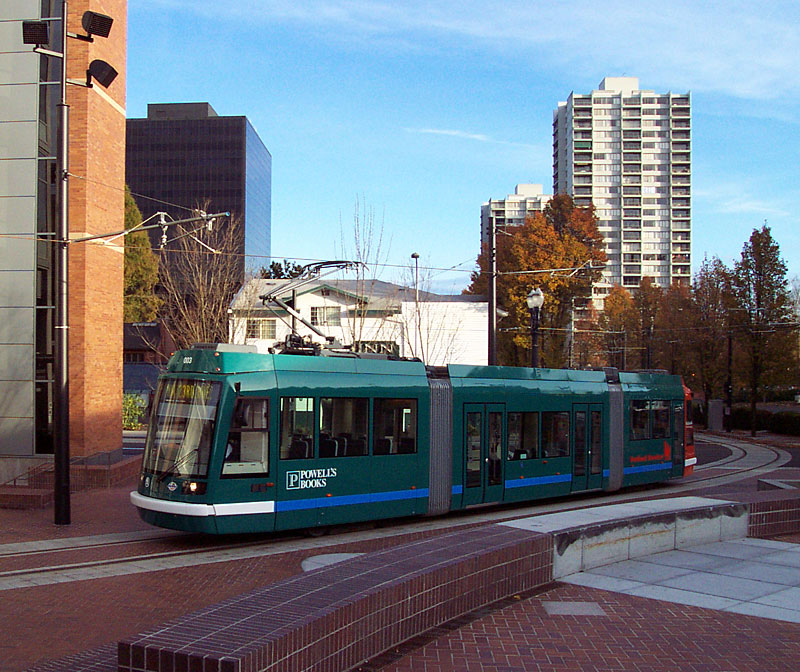
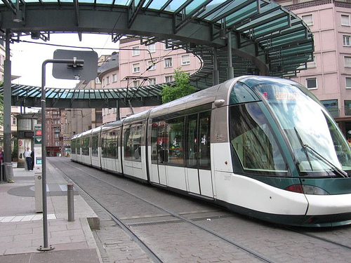
For the uninitiated, the first question one might ask is, "more streetcars?! Like that old-timey trolley thingy on McKinney Avenue? In fact, no. These will be sleek, quiet, comfortable low-floor, accessibly loading modern streetcars. And, I'm told that they will be purchased domestically from a company in Portland (rather than the Siemens cars), so I don't have to spend time belly-aching about bailing out Ford to build more stuff that we don't need rather than overhauling plants to build that which we will.

As freeways were the way to the future for the baby boomer generation, making the streetcar "of its time." Anything resembling nostalgia will limit its potential and reach towards the new population bubble, the Millennials.

Beyond style or preference, I find that the contemporary if not almost futurisitc look is an important indicator of progress to the public at-large. It is a subtle, but important message for building support that the City of Dallas is serious about building a great city rather than any feeble attempts at freezing people in time like a ride at Disney. This isn't about tourists, it is inclusive, but primarily for residents (the significance of which I will explain in a bit).

I expect them to look more like these Portland cars...
http://www.dogcaught.com/rfimg/0605/streetcar-psu.jpg

But, it is fun to check out what some other cities have:

Lyon

http://www.ecocompactcity.org/Eco-public-transport/big/Tram-big-Strasbourg.jpg
Strasbourg

Your second question might be, "what can this possibly do for me?" First, why turn your nose up at $23 million dollars from the Federal government that isn't going towards highway expansion (although as part of the TIGER grants, somehow something called "innovative highways" [guffaw] received funding including a highway expansion in Dallas. I guess being second in highway lanes per mile just isn't good enough. Kansas City, don't you know everything MUST be bigger in Texas, for better or worse - we make no qualitative distinction, or lest we consider ourselves failures and frankly, we just can't live with that.).

Public transportation can often be a lightning rod because of its relatively high upfront costs and seemingly low revenue generation. It is important to remember that no form of transportation on the history of the planet was ever "profitable" in and of itself. Even for me to ride a bike to the new bowling alley bar in Deep Ellum this Summer requires 1) cost to buy the bike, and 2) energy, ie calories. I have to eat a powerbar to expend the energy to get to my destination. Yet, it seems free, just like it does to hop on the highway and drive to Walmart. The true costs have been "unbundled," so the average person has no idea how much they've been screwed over by the automobile monoculture.

The primary purpose of transportation is to facilitate the functions of city (the transaction of human needs/wants), as Mumford states, "to concentrate the greatest variety of goods and people within that limited area, in order to widen the possibility of choice without making it necessary to travel. A good transportation system minimizes unnecessary transportation; and in any event, it offers change of speed and mode to fit a diversity of human purposes."

Car monoculture dislocates these operational efficiencies and have since, as predicted, proven a failure fiscally, environmentally, economically, socially, and medically.

Second, is that streetcars by nature encourage density (eek density! Arm yourselves with crosses and garlic!) and density pays the bills; it requires less infrastructure per capita lessening the tax burden on everyone. This is the ROI that I spoke of regarding streetcars and transportation in general.

Here is where I say, "this is how transportation should always be thought of, but never is." Except that I am not too naive to understand that it is FAR too easy to externalize certain factors/costs, and convince people that a new highway is actually a good expenditure. The question you have to ask people then really comes down to, how do you want to live, how do you want your city to look?

Third, the streetcars will help to lessen the burden on downtown parking for workers, as streetcar is best suited for short- to intermediate-range commuters. Less demand, with all that supply (OMG ALL THAT SUPPLY) could mean lower costs for parking for commuters into downtown. Though, that is a very slippery slope into circularity of argument.

Fourth, streetcars help lead to safe, interesting, vibrant areas - with unique restaurants and experiences. Note that I didn't say "will." The implication being that streetcars are some magic bullet for livable cities. They are one in a kit of parts. As I've said before, if it isn't part of a chicken/egg dilemma, you probably aren't on the right track toward building more livable cities.

See McKinney Avenue. It took the state's first TIF, will of city leadership/stewardship, and private developers willing to take a monumental risk so big that they had to go oversees to find lending for projects in what was one of the worst areas of the City 20-30 years ago. Now we have things like Crooked Tree coffeehouse, the prototypical third place/hole in the wall, offering character while indicating a mature, resilient, complete neighborhood. (Yes, I shamelessly plug my favorite spots in the City: those that are local, embedded in their community, friendly staff, and full of character.)

---------------------------------------

Historically, streetcars were largely private investment tools for new neighborhood creation. They were a scaled-down version of the common mass transit at the time, trains, and served a scaled-down catchment and service area. In this case, they unlocked the value of land immediately adjacent to very compact downtowns, as developers sought to capitalize on the demand to get out of cities that had become polluted/corrupted by industrialization.

These were the first suburbs and you still see the vestigial remnants of the emergent city forms in Lakewood and Bishop Arts. The underlying forces dictating these efforts were not unlike what continued to happen building further suburbia. The difference however, is that the streetcar suburb was still walkable, it still had a functional urban form, and a workable and predictable hierarchy imposed by the permanence of a fixed-line transportation element where the singular dominance of the automobile and its infrastructure diffused people, spaces, and buildings into "anti-city" where each component not only no longer communicated with the other elements of the urban equation, it now ignored them. Anti-city meant anti-economy.

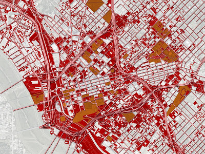
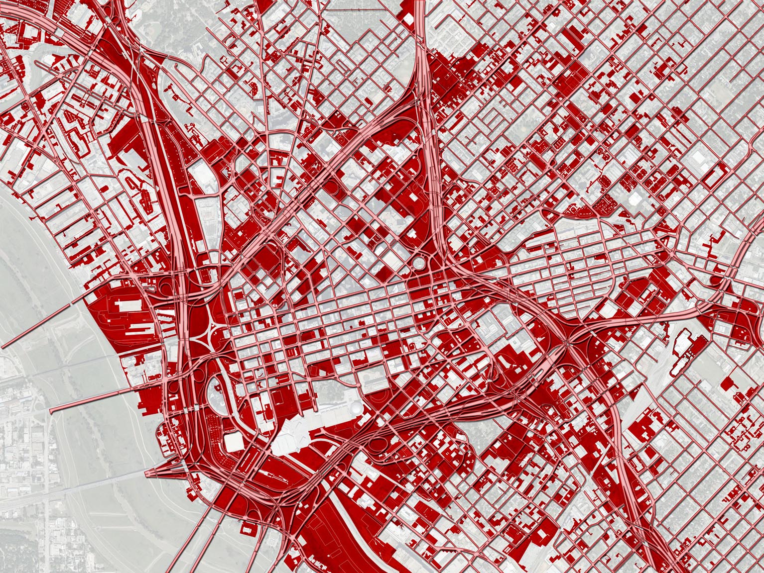
Dallas, feeling its supposed raison d'etre went nuts with the new fangled contraption building over 200 miles and one of, if not, THE most extensive networks in the country, which coincided with a wave of building that made Dallas arguably one of the most beautiful cities in the country. You know the rest of the story.

Not coincidentally, streetcars are logically seen as one of the items to help restore the areas they helped to create one hundred years ago. In the modern megalopolis, each region of the city needs to have the appropriate scales of transportation to serve it in relation to its context. Streetcars typically serve areas within 1/2 and 3 miles of the primary convergence point, core or destination, typically a job center, ie downtown. These are the areas that have become blighted and desolate for the most part, and now have the potential to go from 0 to 60 as fast if not faster than did uptown Dallas because they will be swimming with the tide rather than against what is considered "conventional."

I'm not going to spend much time on the original downtown loop plan since I spent a couple of thousand words on it already, the methodology based on the form of transit and its purpose/history was so fundamentally flawed (or ignored) that it really isn't worth revisiting, but here it is linked if you want to check it out. The right decision was made in the end, I'd like to give the proper credit to those that helped make that decision, so the comments section is wide open for you. I know OCTA had a lot to do with it, but somebody above them had to make that call.

While I think a case can be made for Ross Avenue or Deep Ellum to get the first line, I think it is 1) important politically to address South Dallas and 2) Oak Cliff already has a more robust and defined character that makes the area ripe for success. The goal will be to allow that almost Austin-like [ducks] funkiness to remain under the extreme pressure of investment and new development. Some might call this gentrification, others investment. Either way, it is another engine that must be harnassed to maximize value (of all kinds).

---------------------------------

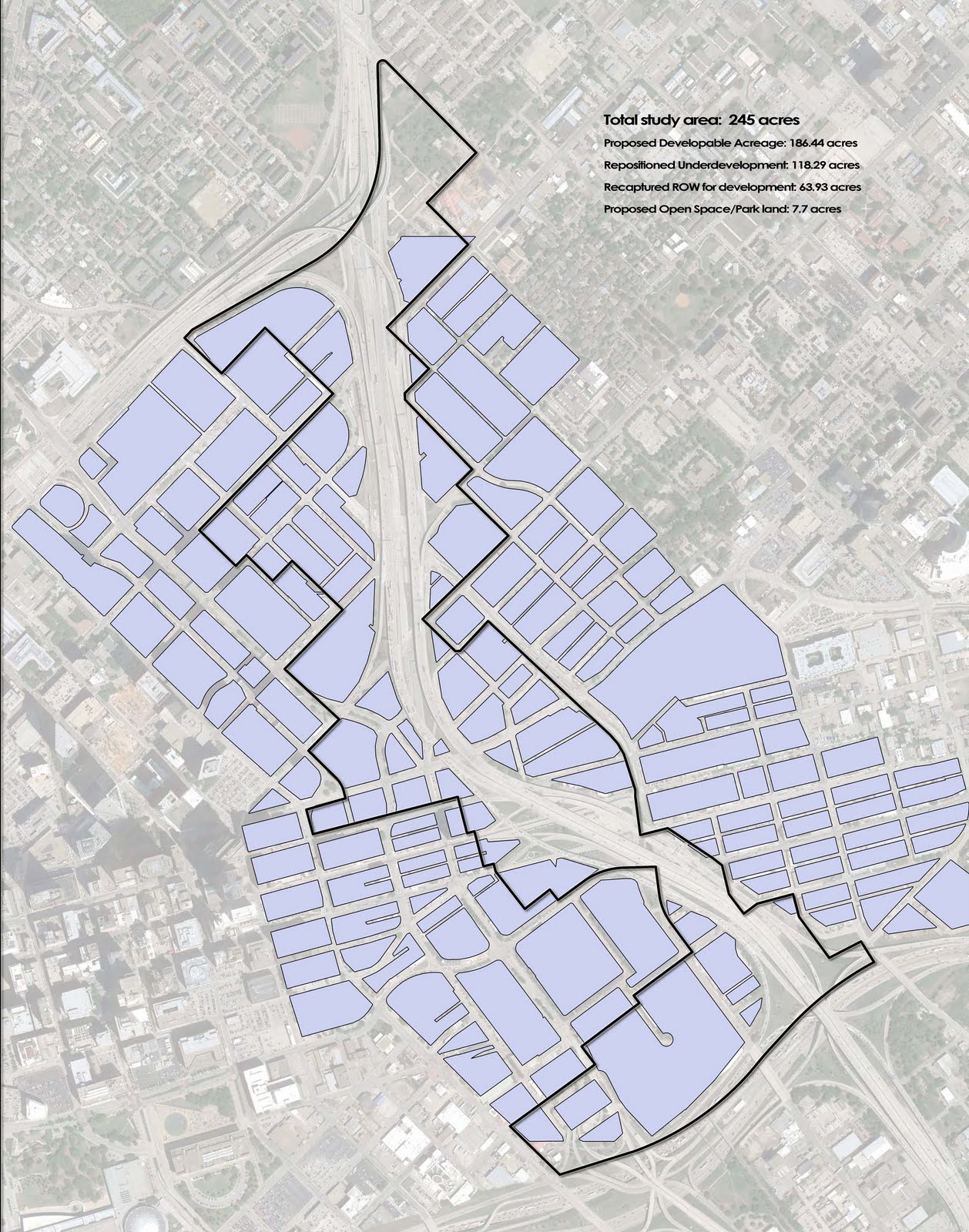
If we are to look at what this grant means to Dallas, Oak Cliff, and the future of the City, the first challenge at hand, is as always, dollars. The sum of federal spending that Dallas will receive, like many of the proposals, is half of what it had asked for. Can the entire line be built after the hat is passed around, or will the first phase be drastically cut short, especially considering that a good portion of the cost will be allocated to a the long Houston Street bridge that will obviously have no private investment immediately adjacent? Are there creative ways to cut costs?

The plan, as stated in the TIGER award, starts at Main Street Garden at Harwood and Main, head west down Main Street to the West End, hang a left on Houston to Union Station, where it will then cross the Trinity into Oak Cliff. The summarized submission then gets a bit vague stating that it will stop at Methodist Hospital before servicing several neighborhoods. I'm guessing if there will be budget cuts, these neighborhoods are what get expanded to at a later date.

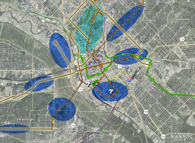
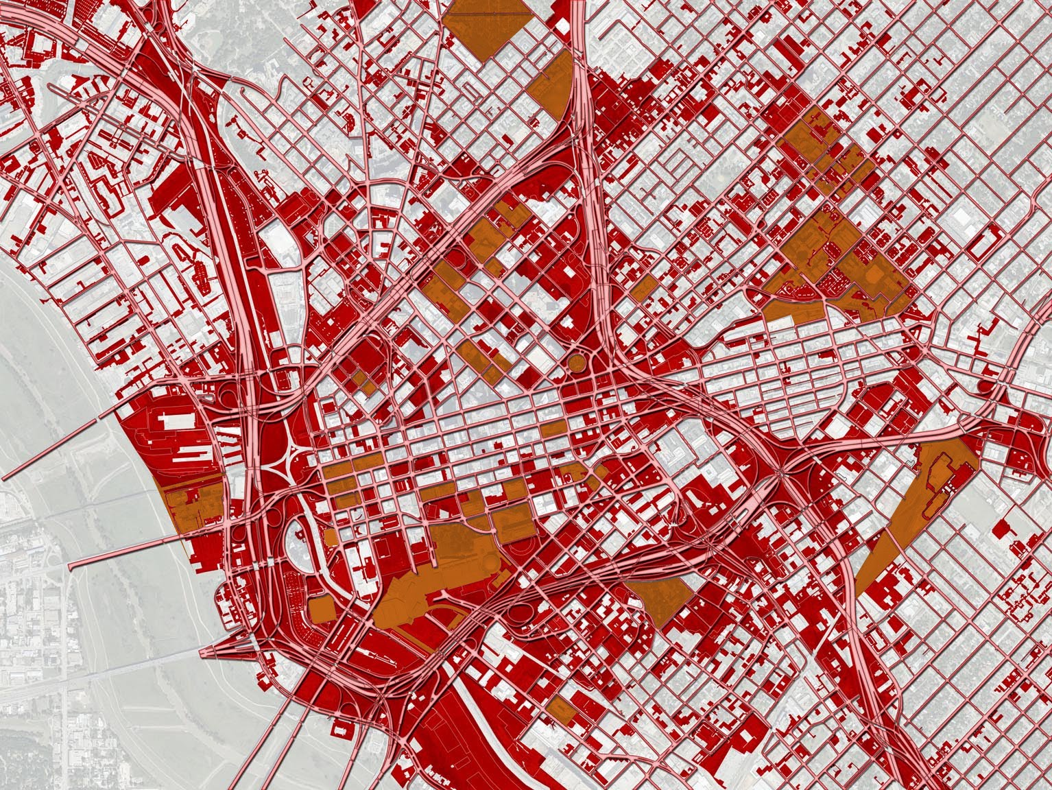
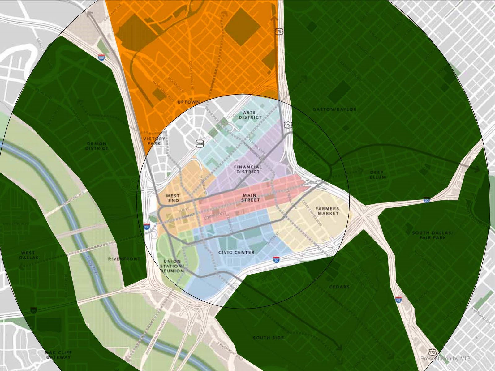
Looking conceptually at how streetcars can strategically reposition areas of Dallas, it helps to establish goals. Mine would be to catalyze reinvestment in the form of high quality walkable urbanism in the districts/corridors shown below. These would all be immediately adjacent to downtown, would create for the kind of urban housing that is proving difficult in downtown, and thus be mutually supportive of downtown Dallas. If I were to prioritize these areas based on need of immediate investment (desperation), readiness (somewhat subjective), and potential for future buildout (or what is the ceiling/highest and best use for this area?), it would be as follows:

1. Oak Cliff (between Bishop Arts and the Trinity)
2. Deep Ellum
2b. Ross Avenue to Lower Greenville
3. Cedars
4. Fort Worth Ave
5. Industrial Ave/Design District
6. Davis Street


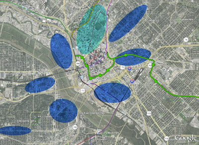
New/Future DART Line in green. Katy Trail in yellow. Uptown area served by MATA in aqua.

So if we add in the new phase, and stop it at Zang and Davis to save approximately $20 million/mile while still serving Methodist Area and being a 1/4-mile within Bishop Arts, I think this would be logical. There might be some desire to loop it back on Beckley, but as I'll get into, I would avoid "loops" in favor of Y- or T-turnarounds in a parking lot if the rights can be had.

(click to embiggen)


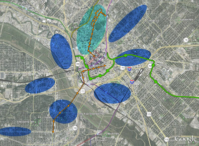
Rather than building loops, the next couple phases should focus on extending lines through downtown to the other areas in need of transportation alternatives and private investment. This would minimize transfer between lines to (typically) one at most. If I'm on Lower Greenville and decide I want to pizza at Eno's in Bishop Arts, if lines criss-cross, I can more predictably navigate my way on two lines max, rather than riding into downtown, catching the downtown circulator to some stop that I might not be sure of to catch the car heading towards Oak Cliff. Amount of transfers can be a mental barrier and should not be underestimated in terms of how it effects ridership.

This expansion consists of probably three phases. The first that I would execute would be to extend the MATA to Main Street meeting the new line, which would simultaneously be extended into Deep Ellum, thus directly linking Bishop Arts and Deep Ellum on one line. The next phase would take a radius line from the Arts District on Ross to Lower Greenville.


Eventually, the MATA/uptown line that is now extended to Main Street would continue down St. Paul to Old City Park and into the Cedars. If you look closely (or click to embiggen) I included several graphics along with this line. The first that I would like to discuss is the questionmark within the Cedars loop. As I said earlier I don't care for one-way loops. Maintaining both directions within one right-of-way creates for more predictability and "convergence," which is necessary for commercial or mixed-use areas. This also allows for movement all on one-track with switch points at stopping areas for cars in different directions to pass. This can be cheaper but difficult to design.

Also, one-way loops makes permanent one-way roads. We may not be ready for them now, but we might some day. And, in fact I would call it a priority to start thinking of all downtown roads as places rather than escape routes (link to highway as agent of disinvestment) and begin converting them to two-way streets. If you know me, you know that I often stress flexibility and adaptability, as none of us is clairvoyant enough to design for 2050 issues, but we can allow for the ability of those who are living in them.

The Cedars however, and areas like it that exist essentially as peninsulas, it will be primarily residential with some smaller scaled-neighborhood support type functions rather than any kind of high intensity mixed-use or commercial that you might see along Ross, Davis, or in Downtown.

Furthermore, in residential areas, you want to get as close to the residents (in this case even the hypothetical ones) as possible. With streetcar, the catchment area may only be 1/4-mile and with the dimension of the Cedars it makes sense to loop the track on Corinth, Lamar, and then Cadiz back to St.Paul (as shown). This would reposition the maximum amount of city blocks for redevelopment/improvement.

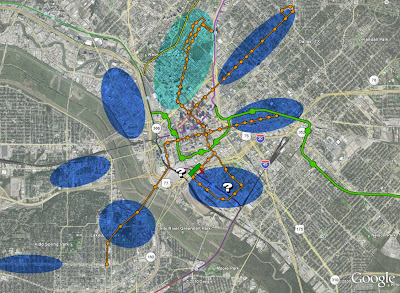
At Woodall Rogers, you will see a red "X" and a green blob. The red X would represent the cleaning up or "context-sensitizing" of R L Thornton through downtown. Cloverleafs are a property value killer and highly inefficient use of land that should be much too valuable for a spacious on/off ramp. These should be cleaned up. The green blob would be a new deck park (ya know, provided any/all of these highways go away as they should) over the freeway. This repositions the south side of the convention center (to help alleviate the gigantic barrier that the CC is) as potentially new office development and the North side of the Cedars as higher density residential/mixed-use on the park. This part of the street car phase then would complete a loop between Main Street Garden, Old City Park, and a new deck park.

Long-term:
Obviously highly conceptual.


Monday, August 31, 2009

Is Harvard Cribbing From Me Again?

I'm just kidding about the poaching of ideas, b/c in actuality they are more like memes or thought viruses spreading and taking hold to approach the necessary issues of the day, but the Harvard Business Review is starting to seriously address the issue and impossibilities of forever growth:

Economists describe this new model in many ways. One way is to use human cellular structures as a metaphor for economic growth. Call it cellular economic theory.

What do cells tell us about business? Well, consider that cells that grow continually and exponentially (like we've been taught our economies should grow) are a form of cancer. We know intuitively and logically that continuous growth can't be sustained in living things. It's likewise unsustainable (and undesirable) in business.

and the relevant examples:

For example, a brewery in India is using cellular economic thinking to grow its bottom line without producing and selling more beer. Instead it's using chaff and grain detritus to create fertilizer and biofuels--regenerating resources to lower their own production costs while widening the life cycles of their inputs.

KATIKA, a Swiss wood furniture maker, is reforesting at a rate greater than their production, using profits from their sales today to ensure the availability of resources later. In the meantime, their reforestation projects create local jobs and other sustainable benefits (home for wildlife and food, CO2 reduction) while increasing the value of formerly degraded land holdings.

Monday, March 9, 2009

The Real Issue with Wall Street (and your 401K)


On HuffPuff, Ann Pettitfor writes about Wall Street holding the U.S. for ransom.

JHK suggests something similar regarding the "too big to fail" myth.

The "ahha" moment I had this weekend whilst walking the mutt on another warm but blustery Downtown Dallas day, was what Wall Street's deeper issue is, beyond the credit default swaps, the ARM loans, greed, etc. All of the companies on the DOW or S&P 500 are huge corporations. They can't physically or economically get any bigger, which is what Wall Street, investors, and your 401K demand, so in turn, they all need to, and are currently shrinking (my publicly traded company included - love those stock options!)

This is the problem with growth. It was touched upon on this week's Bill Maher show with guest Cory Booker. Except that nobody really put 2 and 2 together to realize that there are different types of growth. I have mentioned exhaustively qualitative over quantitative models of growth, but I also touched upon it here:
Let me be the first to say (with thoughts for the other side of this bottoming), that instead of saving dinosaurs, how about we start thinking about saving that money to help startups on the other side of this bottoming that will be smaller, nimble, and more able to meet the needs of the 21st century.
Harvard economist Howard Glaeser echoed my sentiment:
That is how innovation works: small companies competing like crazy and trying out new things. Across cities, there is a strong connection between an abundance of small firms and local growth. The last thing that the government should be doing is propping up big declining firms. Real innovations are far more likely to come from someone’s garage, which is where Chester Carlson came up with the Xerox machine during the Great Depression.
The advantage of Wall Street and Globalization (and I'm one to point out its failings as well) is to deliver capital to companies in need of it for their own growth and economic development for all of us. Nay, this is the POINT.

Instead, it has devolved into a guessing game of who is gonna buy out whom, who will report the best 4Q sales figures, or simply who is the best at hiding their illegal ponzi schemes. Another dinosaur, a construct built entirely to pick the horse that will be standing at the end when only the biggest corporate fish is left. What then? How will our 401K improve at that point?

Well, we're essentially there already. We know that in order to maintain "growth" figures, that these corporations can now only cut costs while trying to provide the same or similar product, which has had disastrous effects on the health of our economies and our physical health.

Wall Street to have a real purpose and contribute to the rebuilding of a real economy is to find a way to deliver the engine of capital that only they can provide to the innovators of the 21st century, the inventors, the biologists, the "green" technicians.

Only then will your 401K begin to shed its sickly sallow look.