[edit: I went down to check out the site today and discovered that "Wonderview" is actually the name of a dead end street and a park. At least it has some contextual backing.]Now that Car-(over)Dependent life has 'jumped the shark', the exploratory search engine of cities (comprised of the worker bee triumvirate of investors, developers, and planners) have begun to look for value in other places. That value would be defined as opportunity for profit (economical, social, environmental) found in the increment between current value and potential future value.
The skill for investors/developers/planners is to properly assess the risk and ensure all is done to find the maximum possible sustainable, durable, and resilient value. For example, now that the value at the edges of the city has now either overshot its value or reached saturation of utility (aka current value = proposed value), many of those properties will either revert to nature or agricultural production, lesser value. The land has undergone the test of time and the value of the cul-de-sac was a tragic misstep where some homeowner won't be able to derive their retirement.
This applies to all that invest in property, whether it be homeowners or developers. The homeowner (ideally) should be searching for value based on their own needs (are they raising a family? How are the schools? Are the streets safe? Does it provide the creature comforts for families? etc.) Both are searching for more value than they pay for the property. Capitalism 101 at work. If you have a comfortable abode, that is plenty enough value for you to make a home for life if your goal isn't to catch the upswing of the city evolutionary search engine qualitatively uplifting the particular area.
The more risk averse property developers are beginning to tip toe across 75 into the previous uncharted territory between 75 and Greenville. New homeowners are buying East of White Rock Lake. The more daring are heading towards South Dallas, more specifically (and currently) Oak Cliff*. Often the most daring can be rewarded handsomely as long as their timing is right to coincide with the inertia of incremental increase in certain areas. Now, the most maverick-y of the
Mavericks is daring to cross the Trinity himself as a proposal to expand a Transit-Oriented Tax Increment Financing Zone to new property on Kiest Boulevard goes in front of City Council today.
TIFs are a creative form of public-private partnership. The beauty is that they don't really put the City on the hook the way a Bond package might, like a loan. A TIF allows the investor/developer to front the necessary infrastructural improvements to make a site more viable and then get paid back by the taxes generated by the qualitative improvement of the property. When they are successful in bringing nectar back to the hive, we are all richer for it.
State-Thomas was the first TIF in the state of Texas and it paid off handsomely, adding potentially as much as $2 billion in investment and improvements to the area. Of course, the City is also littered with bad TIFs like crack vials on the street as the City thought it found its new wonder drug. Like many pharmaceuticals or narcotics, they can be helpful in appropriate and measured dosage and usages. Or they can be toxic.
As this City, like many throughout the country, shifts from expansion to contraction mode within the evolutionary search engine timeline, it is critical to tie public-private partnerships such as TIFs to something that has a measure of permanence and stability to help manage the risk inherent in pioneering, searching for new value. This is why it is critical to tie TIFs to TODs aka areas with multi-modal transportation available. It is also why fixed rail alignments of trains and streetcars are vital to a City. They don't move and the City adapts to them, unlike non-fixed forms like buses. This adds another measure of stability and durability.
Because of this, Cuban Enterprises et al are wise to cover their risk with a public-private partnership such as the expansion of the TIF. The issue however is that TOD is generally considered to be area within walking distance of a public transit line or roughly 1/2 mile. The property in question is about 1.3 miles as the Grackle flies from the Illinois Blue Line DART station. Unfortunately, Grackles don't ride trains. They multiply and cackle.
Fortunately, a more robust hierarchy of mass transportation comes to the rescue. Right now, the most viable forms of transportation are car and DART train (until the City passes its awkward, gangly teenager form of urbanism, I won't consider buses as legitimate). And currently, very few areas in this City can be considered walkable or bikable.
This is where it makes a lot of sense to establish an "urban circulator" and fund it through the TIF and Federal Programs of a similar name and loop it from Illinois Station to the new development. Bam, TOD. These can be streetcars, jitneys, or buses, and their purpose is to bridge the gap between safe and comfortable walkable distances (very short in unwalkable locations) and the larger catchment area of a station (often .5 to 3 miles depending upon density and proximity of other stations).
Another reason to expand the TIF boundary is that between the fragmented ownership and fragmented parcelization due to the suburban-style road network near Illinois Station creates unnecessary and difficult to overcome barriers to investment. Otherwise, with the TIF in place, we would have seen more incremental and profound changes already.
Thinking long-term and looking at the broader context, Kiest Blvd has the potential for streetcar. Obviously, I am a big believer in the power of streetcars to revitalize areas within five miles of downtown. As all infrastructure unlocks value in new areas to some extent (at least the testing of value), streetcars were the catalyst for the now inner ring areas in the first place. They will again be the agents of change as we focus our contraction phase efforts (qualitative improvement of existing development aka infill) around transit, walkability, and infill.
Think about this, Kiest Blvd heading North merges with Cedar Crest Blvd before crossing the Trinity and becoming Martin Luther King Jr Blvd, which then runs directly to Fair Park. It might take 20, 30, or 50 years, but I would rename the entire portion of Kiest/Cedar Crest as MLK, start planning a streetcar linking Fair Park, Trinity River, and this new development (even to Kiest Station possibly) and be done with it.
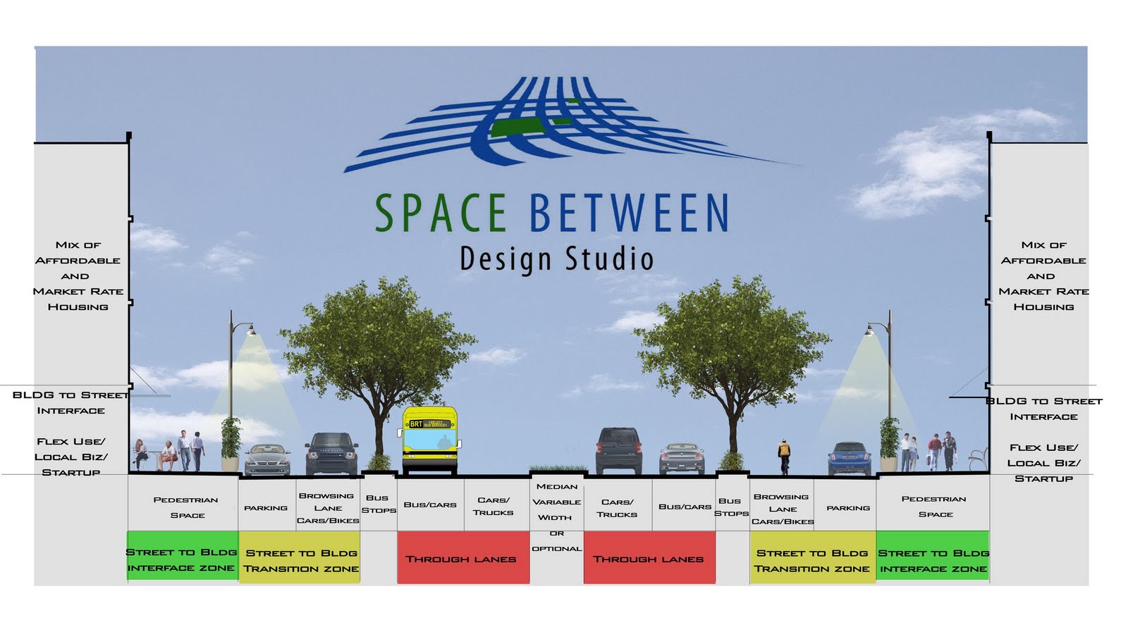
We can start by converting the street section into a
complete street as well. There is plenty of width between the unnecessary drive lanes and wide median to support space for cars, transit, bikes, and pedestrians. Where better for the City to show that they are committed to 1) South Dallas and 2) recapturing the potential human and economic value of streets from car dominance.
All of that however, is still long-term when in actuality we are still in the placeholder stage of generic water color imagery while the deal gets worked out. I will hold off on much comment on the masterplan because much of it is a placeholder (it isn't bad, but I also don't think it is the most sophisticated of plans -- which reminds that it is early and of the plan's ephemeral infancy).
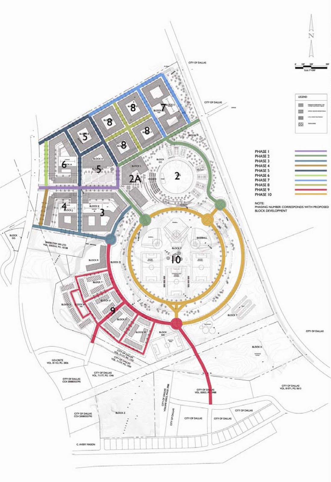
What tends toward some measure of permanence and definition is the phasing strategy for the infrastructure. If the City goes in on a deal, they typically don't like a bunch of things shifting around. While many people will be drawn to the renderings, the plans below are where more critical attention needs paid (sic: PA colloquialism for a Carnegie Mellon grad).
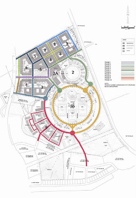
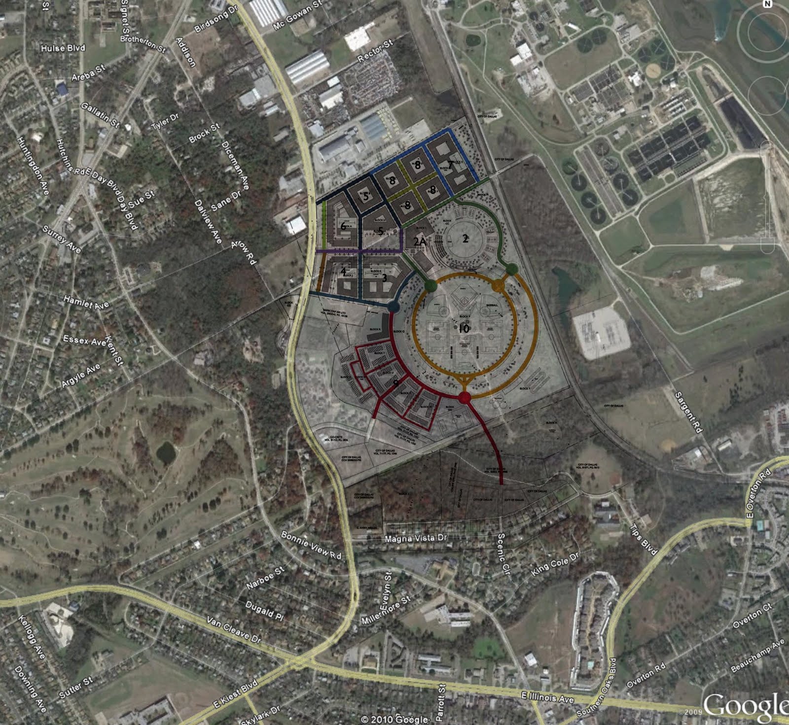
Since architects are so often loathe to work in the unfortunately necessary world of context, I'll add the plan to an aerial for you to get a better sense of the plan and the challenges (ie lack of positive inertia and negative adjacencies such as an automobile graveyard -- fitting no?) facing the site.
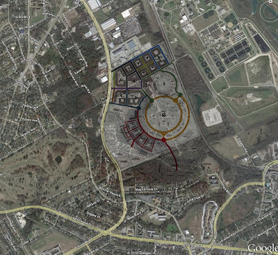
The plan is rather internalized (notice the tray of parking as buffer between Heist and the first buildings). But without improvement of Kiest, the plan is unfortunately forced to be a roadside attraction, turning its back on an inhumane road (that's exactly the word I meant) rather than a transportation system and development that is fully integrated, allowing it to reach the full potential of its value. (I would strongly recommend some deeper thought goes into this to which I have ideas but I won't reveal any unless contacted. I provide a lot of content/ideas for free, but I ain't that cheap.)
The tragedy of 20th century city planning is the task of the 21st.The project is big. It's bold (although I believe there is more value in being even bolder in some regards). I like the initiative. I like the Southerly investment. However, it is not without several challenges; not the least of which is the status as being the pioneer and proving the market up. To underplay or (willfully or otherwise) ignore those challenges is to ensure failure.
There is a HUGE unmet market for high quality urbanism, but will this particular area prove to be a coalescent points of the urban contraction? Of course, Mark Cuban is no stranger to being the explorer himself, having made his wealth pioneering another territory, these here interwebs. First in, can pay off handsomely no?
While to the Northwest in the Bishop Arts and X+ vicinities, qualitative improvement is happening from the bottom-up through self-organizing urbanism and shared needs and wants amongst a burgeoning community. Therein lies its strength and future stability. Lacking these, they are also the challenges faced here, lacking inertia and stable adjacencies.
Perhaps without waiting for the expansion of that success, this is the right time and place for a large, top-down development (the kind that tend towards awful names that won't stick). I once told somebody there are two things a developer must do to ensure the long-term value of a project (ideally both). Create a place that is so special people will love it and care for it in perpetuity OR forge meaningful connections to any and all adjacencies to ensure mutual interconnected fates, shared responsibility for stewardship and value maintenance of an area.
This area currently lacks those connections (other than a surprisingly good/cheap golf course). This project can be the anchor to which other investment moors its boat (the kind that makes it too valuable for auto-graveyards close to downtown), which is exactly why, if Cuban plans on putting his HQ here (necessary 1st phase - attractor - employment center), we (the City) should be supportive and expand the TIF boundary with a linking circulator.
------------------------------------------
*note: I am lumping Oak Cliff and South Dallas together as I am of the professional opinion that South Dallas will see its resurgence from the edges. Growing the renewed interest in Oak Cliff southward and building upon UNT's plans for a new campus northward. Because cities and properties are inherently interconnected, it is far easier to build off points of inertia than to completely overhaul areas from scratch without momentum.
-------------------------------------------